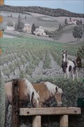
 view gallery view gallery N3.9 km N3.9 km
|   Les chevaux - Chessy les mines - Rhône Les chevaux - Chessy les mines - Rhône
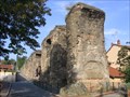
in Murals mural in the land of golden stone
fresque murale au pays des pierres dorées posted by:  JMRetSB JMRetSB location: Auvergne-Rhône-Alpes, France date approved: 10/15/2013 last visited: 10/05/2013 |
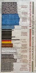 view gallery view gallery NE5.5 km NE5.5 km
|  Pierres folles - 201Ma to 190Ma - Saint-Jean-des-Vignes - France Pierres folles - 201Ma to 190Ma - Saint-Jean-des-Vignes - France
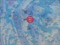
in Timelines 10 Ma reveal themselves. The fault of crazy stones is the result of a field movement due to the formation of the Alps /\ 10 Ma se révèlent. La faille de pierres-folles est le resultat d'un mouvement de terrain du à la formation des Alpes. posted by: JMRetSB location: Bourgogne-Franche-Comté, France date approved: 05/23/2017 last visited: 02/13/2020 |
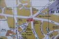 view gallery view gallery SE9.2 km SE9.2 km
|  La tour-de-Salvagny - Rhône - France La tour-de-Salvagny - Rhône - France
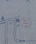
in 'You Are Here' Maps Locate on the map of the town of La Tour-de-Salvagny /\ Localisation sur le plan de la commune de La Tour-de-Salvagny. posted by: JMRetSB location: Auvergne-Rhône-Alpes, France date approved: 09/28/2017 last visited: 02/13/2020 |
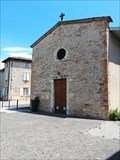 view gallery view gallery E10.9 km E10.9 km
|  Eglise Saint-Roch - Les Chères, France Eglise Saint-Roch - Les Chères, France
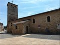
in Roman Catholic Churches [EN] A small 14th century church in a village, on the edge of the national road 6, the road for holidays. [FR] Une petite église du XIVe siècle dans un village, en bordure de la nationale 6, la route des vacances. posted by: pmaupin location: Auvergne-Rhône-Alpes, France date approved: 08/07/2019 last visited: 07/09/2019 |
 view gallery view galleryE10.9 km |  Eglise Saint-Roch - Les Chères, France Eglise Saint-Roch - Les Chères, France
in Medieval Churches [EN] A small 14th century church in a village, on the edge of the national road 6, the road for holidays. [FR] Une petite église du XIVe siècle dans un village, en bordure de la nationale 6, la route des vacances. posted by: pmaupin location: Auvergne-Rhône-Alpes, France date approved: 08/06/2019 last visited: 07/09/2019 |
 view gallery view galleryE10.9 km | Eglise Saint-Roch - Les Chères, France in This Old Church [EN] A small 14th century church in a village, on the edge of the national road 6, the road for holidays.
[FR] Une petite église du XIVe siècle dans un village, en bordure de la nationale 6, la route des vacances. posted by: pmaupin location: Auvergne-Rhône-Alpes, France date approved: 08/06/2019 last visited: 07/09/2019 |
 view gallery view galleryE10.9 km |  Le Clocher de l'Eglise Saint-Roch - Les Chères, France Le Clocher de l'Eglise Saint-Roch - Les Chères, France
in Bell Towers [EN] A small 14th century church in a village, on the edge of the national road 6, the road for holidays. [FR] Une petite église du XIVe siècle dans un village, en bordure de la nationale 6, la route des vacances. posted by: pmaupin location: Auvergne-Rhône-Alpes, France date approved: 08/06/2019 last visited: 07/09/2019 |
 view gallery view galleryE14.3 km | La découverte des Monts d'Or in 'You Are Here' Maps Point central des Monts d'Or offrant une très belle vue sur Lyon ainsi qu'un espace de jeux. posted by: JOJO_Family location: Auvergne-Rhône-Alpes, France date approved: 06/16/2014 last visited: 06/28/2014 |
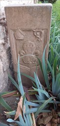 view gallery view galleryNE14.6 km |  Borne de la Dîmerie - Limas , France Borne de la Dîmerie - Limas , France
in European Historic Survey Stones, Monuments and Benchmarks Cette borne se situe dans la commune de Limas. Elle représente un témoin de l'Histoire.
This terminal is located in the municipality of Limas. It represents a witness of history. posted by: Georgioturino location: Auvergne-Rhône-Alpes, France date approved: 03/16/2023 last visited: never |
 view gallery view galleryE16.7 km | Sentier des rapaces in 'You Are Here' Maps Sentier de découverte.
Parcours aménagé de 1.9km aller retour. posted by: JOJO_Family location: Auvergne-Rhône-Alpes, France date approved: 06/05/2014 last visited: 06/06/2014 |
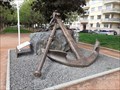 view gallery view galleryNE16.9 km |  Don d'une ancre à Villefranche-sur-Saône , France. Don d'une ancre à Villefranche-sur-Saône , France.
in Anchors Ancre en hommage de Villefranche-sur-Saône à la Marine Nationale. posted by: Georgioturino location: Auvergne-Rhône-Alpes, France date approved: 12/09/2021 last visited: never |
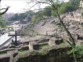
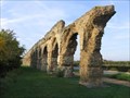 view gallery view gallerySE18.5 km |  Aqueduc du Gier - Chaponost Aqueduc du Gier - Chaponost
in Ancient Roman Civilization The Gier was the youngest, longest and highest of the four aqueducts of Lugdunum and had been built in Opus Reticulatum in its whole line. In order to cross the many valleys in its 86 km course, four siphons and 25 bridges ware built. posted by: RakeInTheCache location: Auvergne-Rhône-Alpes, France date approved: 10/14/2007 last visited: 11/05/2023 |
 view gallery view gallerySE18.5 km |  Aqueduc du Gier - Chaponost Aqueduc du Gier - Chaponost
in Ancient Aqueducts The Gier was the youngest, longest and highest of the four aqueducts of Lugdunum and had been built in Opus Reticulatum in its whole line. In order to cross the many valleys in its 86 km course, four siphons and 25 bridges ware built. posted by: RakeInTheCache location: France date approved: 10/13/2007 last visited: 11/05/2023 |
 view gallery view gallerySE18.8 km | Aqueduc du Gier - Fourvière in Ancient Aqueducts This spot identifies the where the top of the Gier Aqueduct siphon across the valley between Chaponost and the Fourviere hill appears on the top of the Fourviere hill as it enters into Lugdunum (Lyon). posted by: RakeInTheCache location: France date approved: 10/13/2007 last visited: 08/05/2015 |
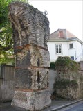 view gallery view gallerySE18.8 km | Aqueduc du Gier - Fourvière in Ancient Roman Civilization This spot identifies the where the top of the Gier Aqueduct siphon across the valley between Chaponost and the Fourviere hill appears on the top of the Fourviere hill as it enters into Lugdunum (Lyon). posted by: RakeInTheCache location: Auvergne-Rhône-Alpes, France date approved: 10/15/2007 last visited: 08/05/2015 |
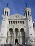 view gallery view gallerySE19.2 km | Basilica Notre-Dame de Fourvière - Lyon, France in This Old Church The Basilica Notre-Dame de Fourvière is a basilica in Lyon. Built between 1872 and 1896, its unusual design draws from a variety of architectural influences. posted by: RakeInTheCache location: France date approved: 10/13/2007 last visited: 10/29/2023 |
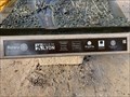
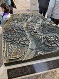
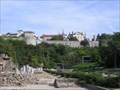 view gallery view gallerySE19.2 km | Le musée gallo-romain de Fourvière - Lyon in Ancient Roman Civilization The museum and the archeological site occupy the slopes of the Fourviere hill, once the center of the Roman city of Lugdunum, founded in 43 B.C. posted by: RakeInTheCache location: Auvergne-Rhône-Alpes, France date approved: 10/15/2007 last visited: 10/29/2023 |
 view gallery view gallerySE19.2 km |  Le musée gallo-romain de Fourvière - Lyon Le musée gallo-romain de Fourvière - Lyon
in History Museums The museum and the archeological site occupies the slopes of the Fourviere hill, once the center of the Roman city of Lugdunum, founded in 43 B.C. posted by: RakeInTheCache location: Auvergne-Rhône-Alpes, France date approved: 10/13/2007 last visited: 10/29/2023 |
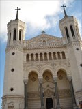 view gallery view gallerySE19.2 km |  Basilique de Fourvière - Lyon, France Basilique de Fourvière - Lyon, France
in Monuments Historiques Français The Basilica of Notre-Dame de Fourvière is a minor basilica in Lyon. It was built with private funds between 1872 and 1896 in a dominating position in the city. posted by: tmob location: Auvergne-Rhône-Alpes, France date approved: 03/28/2011 last visited: 10/29/2023 |
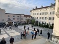 view gallery view gallerySE19.2 km |  Le chemin de croix de Fourvière - Lyon - France Le chemin de croix de Fourvière - Lyon - France
in Outdoor Stations of the Cross Sur le parvis de la basilique de Fourvière, un chemin de croix borde l'ensemble de l'esplanade.
On the forecourt of the basilica of Fourvière, a way of the cross borders the whole esplanade. posted by: Alfouine location: Auvergne-Rhône-Alpes, France date approved: 10/14/2022 last visited: 10/29/2023 |
 view gallery view gallerySE19.2 km | Aqueduc du Gier - Saint-Foy in Ancient Roman Civilization This spot identifies the bottom of the Gier Aqueduct siphon between Chaponost and the Fourviere hill where it crosses the valley. posted by: RakeInTheCache location: Auvergne-Rhône-Alpes, France date approved: 10/14/2007 last visited: 11/05/2023 |
 view gallery view gallerySE19.2 km | Aqueduc du Gier - Saint-Foy in Ancient Aqueducts This spot identifies the bottom of the Gier Aqueduct siphon between Chaponost and the Fourviere hill where it crosses the valley. posted by: RakeInTheCache location: France date approved: 10/13/2007 last visited: 11/05/2023 |
 view gallery view gallerySE19.2 km | Roman Theater of Lugdunum (Lyon) in Ancient Roman Civilization The large Roman theater was built around 15 B.C. and is one of the oldest in Gaul. posted by: RakeInTheCache location: Auvergne-Rhône-Alpes, France date approved: 10/15/2007 last visited: 10/29/2023 |
 view gallery view gallerySE19.2 km |  La ville de Lyon - France La ville de Lyon - France
in Rotary International Markers « Regard sur la ville » est une grande sculpture en bronze et en pierre destinée d’abord à permettre aux personnes non voyantes de découvrir le patrimoine de Lyon. Elle est installée sur l'esplanade de Fourvière avec une superbe vue sur la vue. posted by: Alfouine location: Auvergne-Rhône-Alpes, France date approved: 10/14/2022 last visited: never |
 view gallery view gallerySE19.2 km |  La ville de Lyon - France La ville de Lyon - France
in Accessible-Designed Recreational Locations « Regard sur la ville » est une grande sculpture en bronze et en pierre destinée d’abord à permettre aux personnes non voyantes de découvrir le patrimoine de Lyon. Elle est installée sur l'esplanade de Fourvière avec une superbe vue sur la vue. posted by: Alfouine location: Auvergne-Rhône-Alpes, France date approved: 10/30/2022 last visited: never |
|