 view gallery view gallery N12.1 km N12.1 km
|   Potey Sundial, Rosans, France Potey Sundial, Rosans, France
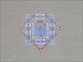
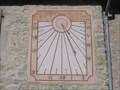
in Sundials On the town hall (Marie) in Rosans, Rémi Potey painted a sundial in 1995. Rosans is a hill village in the heart of the Baronnies, at the border of Hautes Alpes and Drome. posted by:  arby101ca arby101ca location: France date approved: 06/20/2010 last visited: never |
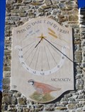
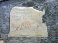 view gallery view galleryN12.1 km | "La Vie" Sundial, Rosans, France in Sundials "La Vie" is a sundial on the wall of an old house within the wall of the town of Rosans. posted by: arby101ca location: France date approved: 08/03/2010 last visited: never |
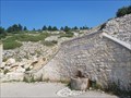
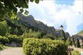
 view gallery view galleryN12.2 km |  Eglise de Rosans (c) Eglise de Rosans (c)
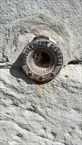
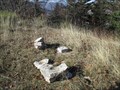
in French Benchmarks REPERE CYLINDRIQUE DU NIVELLEMENT GENERAL posted by:  JMRetSB JMRetSB location: Provence-Alpes-Côte d'Azur, France date approved: 05/17/2015 last visited: 05/09/2015 |
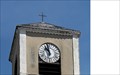 view gallery view galleryN12.2 km | Eglise de Rosans (a) in French Benchmarks Azimut de la prise de vue posted by: JMRetSB location: Provence-Alpes-Côte d'Azur, France date approved: 05/17/2015 last visited: 05/12/2015 |
 view gallery view gallery NE15 km NE15 km
| 1777 Sundial in Montjay, Hautes Alpes, France in Sundials In the village of Montjay, in the Pays de Buech, Hautes Alpes, France is a sundial dated 1777 restored by Atelier Tournesol in 1986 posted by: arby101ca location: France date approved: 05/16/2010 last visited: never |
 view gallery view galleryNE16.7 km | Peyrot Sundial on Church in Ribeyret, Hautes Alpes, France in Sundials The Peyrots created this elegant sundial on the church in Ribeyret in 1996. Ribeyret is a hamlet in Pays de Buech, Hautes Alpes, west of Serres. posted by: arby101ca location: France date approved: 06/16/2010 last visited: never |
 view gallery view gallery W17.2 km W17.2 km
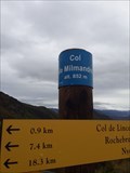
|  852m - Col de Milmandre - Beauvoisin, France 852m - Col de Milmandre - Beauvoisin, France
in Elevation Signs Col de Milmandre sur le GR9 /
Col de Milmandre on the GR9 posted by: GroVicking location: Auvergne-Rhône-Alpes, France date approved: 06/11/2020 last visited: never |
 view gallery view gallery E17.4 km E17.4 km
| Tournesol Sundial on Ste Colombe Chapel, France in Sundials Atelier Tournesol created a sundial in 1986 showing a dove on the chapel of Ste Colombe, Pays de Buech, Hautes Alpes, France. posted by: arby101ca location: France date approved: 05/16/2010 last visited: never |
 view gallery view gallery SW17.7 km SW17.7 km
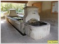
|  Fontaine de la Grave - Bédoin - France Fontaine de la Grave - Bédoin - France
in Fountains [FR] Petite fontaine sur la route du Ventoux.
[EN] Small fountain on the Ventoux road. posted by: PaulLassiter location: Provence-Alpes-Côte d'Azur, France date approved: 09/23/2018 last visited: never |
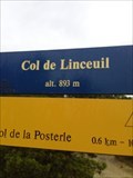 view gallery view galleryW18 km | 893m - Col de Linceuil - Rochebrune, France in Elevation Signs Col du Linceuil sur le GR9 / Col du Linceuil on the GR9 posted by: GroVicking location: Auvergne-Rhône-Alpes, France date approved: 04/12/2020 last visited: never |
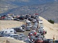
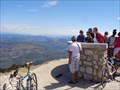 view gallery view gallerySW18 km |  Mont Ventoux - Provence/France Mont Ventoux - Provence/France
in Orientation Tables Orientation table at the summit of Mont Ventoux. posted by: KaPsTeam location: Provence-Alpes-Côte d'Azur, France date approved: 08/09/2015 last visited: 02/23/2021 |
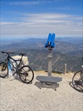 view gallery view gallerySW18 km |  Binocular at the summit of Mont Ventoux - Provence/France Binocular at the summit of Mont Ventoux - Provence/France
in Coin-Op Binoculars Binocular at the summit of Mont Ventoux near the road D947. posted by: KaPsTeam location: Provence-Alpes-Côte d'Azur, France date approved: 08/11/2015 last visited: 02/23/2021 |
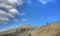
 view gallery view gallerySW18 km |  Mont Ventoux - Provence/France Mont Ventoux - Provence/France
in Scenic Roadside Look-Outs Road lookout at the summit of Mont Ventoux. posted by: KaPsTeam location: Provence-Alpes-Côte d'Azur, France date approved: 08/10/2015 last visited: 02/23/2021 |
 view gallery view gallerySW18.2 km |  Tom Simpson Tom Simpson
in Wikipedia Entries The location is a large memorial stone up steps at the side of the road, adjacent to the spot where Tom collapsed on 13th July 1967. posted by: Happy Humphrey location: Provence-Alpes-Côte d'Azur, France date approved: 08/19/2007 last visited: 09/12/2012 |
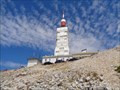
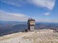 view gallery view gallerySW18.3 km |  Mont Ventoux - Provence/France Mont Ventoux - Provence/France
in Scenic Overlooks Lookout platform at the summit of Mont Ventoux. posted by: KaPsTeam location: Provence-Alpes-Côte d'Azur, France date approved: 08/09/2015 last visited: 02/23/2021 |
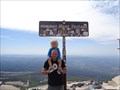
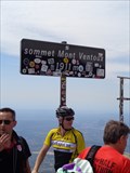 view gallery view gallerySW18.3 km | Summit Mont Ventoux - 1911 meters in Elevation Signs Often photographed elevation sign at the top of Mont Ventoux. posted by: KaPsTeam location: Provence-Alpes-Côte d'Azur, France date approved: 08/08/2015 last visited: 02/23/2021 |
 view gallery view gallerySW18.3 km |  Mont Ventoux - Provence - France Mont Ventoux - Provence - France
in UNESCO Geoparks and Biosphere Reserves Mont Ventoux is a Biosphere Reserve in the south of France. posted by: KaPsTeam location: Provence-Alpes-Côte d'Azur, France date approved: 08/03/2015 last visited: 07/31/2017 |
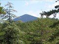
 view gallery view gallerySW18.3 km | Mont Ventoux - Provence - France in Wikipedia Entries The Mont Ventoux is a dominant, 1,912 m high mountain in the French Provence. posted by: KaPsTeam location: Provence-Alpes-Côte d'Azur, France date approved: 08/03/2015 last visited: 02/23/2021 |
 view gallery view gallerySW18.3 km |  Mont Ventoux - Provence - France Mont Ventoux - Provence - France
in Mountain Summits The Mont Ventoux is a dominant, 1,912 m high mountain in the French Provence. posted by: KaPsTeam location: Provence-Alpes-Côte d'Azur, France date approved: 08/03/2015 last visited: 09/12/2012 |
 view gallery view galleryE18.5 km | Atelier Acacia Sundial, Orpierre, France in Sundials Atelier Acacia installed a sundial on a farmhouse west of Orpierre, Pays de Buech, France in 1991 posted by: arby101ca location: France date approved: 07/19/2010 last visited: never |
 view gallery view gallery SE19.3 km SE19.3 km
| ") Lavoir de Montfroc - Montfroc, Auvergne-Rhône-Alpes, France Lavoir de Montfroc - Montfroc, Auvergne-Rhône-Alpes, France
in Lavoir (wash houses) Le lavoir de Montfroc posted by: YvesProvence location: Auvergne-Rhône-Alpes, France date approved: 02/13/2018 last visited: never |
 view gallery view galleryE19.6 km |  Orpierre, France Orpierre, France
in Established Rock Climbing Areas More than 500 routes, from 3a to 8c , spread over many crags posted by: Beeklust location: Hauts-de-France, France date approved: 06/16/2021 last visited: never |
 view gallery view gallery S20.1 km S20.1 km
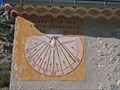
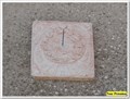
| Cadran de Saint Trinit - Saint Trinit, France in Sundials Un petit cadran de série. A small dial made in series. posted by: YvesProvence location: Provence-Alpes-Côte d'Azur, France date approved: 09/01/2021 last visited: 09/01/2021 |
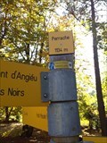 view gallery view gallerySW20.3 km | 1134m - Perrache - Bédoin, France in Elevation Signs Perrache dans le Mont Ventoux /
Perrache in Mont Ventoux posted by: GroVicking location: Provence-Alpes-Côte d'Azur, France date approved: 06/11/2020 last visited: never |
 view gallery view gallerySE20.8 km | Sommet de Larrant - Redortiers - 04 in French Benchmarks Borne en granit gravée IGN posted by: YvesProvence location: Provence-Alpes-Côte d'Azur, France date approved: 12/25/2016 last visited: never |
|