 view gallery view gallery NW15.6 km NW15.6 km
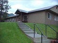
|   Garden Valley Seventh-day Adventist Church Garden Valley Seventh-day Adventist Church
in Seventh-day Adventist Churches Small country church in Crouch, ID posted by:  X$r X$r location: Idaho date approved: 06/02/2008 last visited: never |
 view gallery view gallery S22.2 km S22.2 km
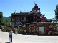
|  Idaho City Junk House Idaho City Junk House
in Junk Design Houses Something of a local icon, this house is festooned with discarded antique objects from this former gold rush town. posted by:  Touchstone Touchstone location: Idaho date approved: 06/24/2007 last visited: 04/02/2009 |
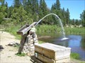 view gallery view galleryS22.7 km |  The Water Giant Fountain The Water Giant Fountain
in Fountains A converted "Monitor" water cannon that used to be used for the purpose of dredging gold from the nearby hills of the gold rush town of Idaho City. posted by: Touchstone location: Idaho date approved: 06/25/2007 last visited: 04/02/2009 |
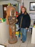 view gallery view galleryS22.9 km |  Idaho City cigar store Indian Idaho City cigar store Indian
in Cigar Store Indians The local 'cigar store' which also happens to be the Sinclair station. posted by: TeamRoadrunner location: Idaho date approved: 01/13/2008 last visited: 08/17/2010 |
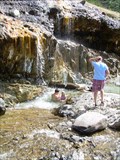 view gallery view gallery E23 km E23 km
|  Kirkham Hot Springs Kirkham Hot Springs
in Hot Springs The Kirkham Hot Springs, located on the south fork of the Payette River, offer rock and sand pools with hot showers. posted by: Touchstone location: Idaho date approved: 06/25/2007 last visited: 06/02/2016 |
 view gallery view galleryE24.3 km |  Emma Edwards #442 Emma Edwards #442
in Idaho Historical Markers A talented artist, Emma Edwards went to work in 1890 to design Idaho's State Seal when she was only 18 years old. posted by: Touchstone location: Idaho date approved: 06/25/2007 last visited: 06/04/2016 |
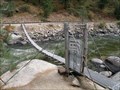 view gallery view galleryNW30.1 km |  Big Eddy Bridge - Idaho Big Eddy Bridge - Idaho
in Pedestrian Suspension Bridges Pedestrian suspension bridge near Big Eddy siding. posted by: Volcanoguy location: Idaho date approved: 02/22/2011 last visited: 10/01/2009 |
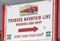 view gallery view gallery SW32.2 km SW32.2 km
|  Thunder Mountain Line - Horseshoe Bend, Idaho Thunder Mountain Line - Horseshoe Bend, Idaho
in Scenic Railroads The Thunder Mountain Line opperates scenic train rides out of Horseshoe Bend, Idaho. posted by: Volcanoguy location: Idaho date approved: 02/22/2011 last visited: 10/01/2009 |
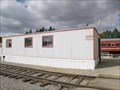 view gallery view gallerySW32.2 km | Thunder Mountain Line Depot - Horseshoe Bend, Idaho in Train Stations/Depots Depot for the Thunder Mountain Line in Horseshoe Bend, Idaho. posted by: Volcanoguy location: Idaho date approved: 02/22/2011 last visited: 10/01/2009 |
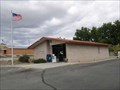 view gallery view gallerySW32.2 km |  Horseshoe Bend, ID. 83629 Horseshoe Bend, ID. 83629
in U.S. Post Offices The post office building in Horseshoe Bend, ID posted by: Volcanoguy location: Idaho date approved: 10/25/2009 last visited: 01/31/2010 |
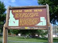 view gallery view gallerySW32.3 km | Horse Shoe Bend #278 in Idaho Historical Markers Gold was struck in the Boise Basin (over the ridge to the East of this site)in 1862, and the rush to these new mines came through here. posted by: Touchstone location: Idaho date approved: 06/25/2007 last visited: 06/20/2019 |
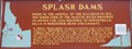 view gallery view galleryNW34.4 km | #496 - Splash Dams in Idaho Historical Markers Splash Dams sign (#496) on Idaho. Hwy. 55. posted by: Volcanoguy location: Idaho date approved: 02/22/2011 last visited: 11/02/2012 |
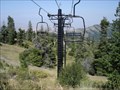 view gallery view gallerySW37 km |  Bogus Basin Ski Resort, Boise ID Bogus Basin Ski Resort, Boise ID
in Winter Sports Locations Medium sized resort, but big on runs. posted by: cachegame location: Idaho date approved: 10/12/2006 last visited: 06/27/2010 |
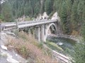 view gallery view galleryNW37.7 km |  North Fork Payette River Bridge, Idaho North Fork Payette River Bridge, Idaho
in U.S. National Register of Historic Places The North Fork Payette River Bridge is located on Idaho Hwy. 55 about 2.5 miles north of Smiths Ferry. posted by: Volcanoguy location: Idaho date approved: 02/21/2011 last visited: 04/26/2011 |
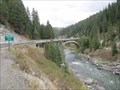 view gallery view galleryNW37.7 km |  North Fork Payette River Bridge, Idaho North Fork Payette River Bridge, Idaho
in Arch Bridges The North Fork Payette River Bridge is located on Idaho Hwy. 55 about 2.5 miles north of Smiths Ferry. posted by: Volcanoguy location: Idaho date approved: 03/01/2011 last visited: 04/23/2011 |
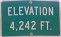 view gallery view gallerySW39.8 km |  Horseshoe Bend Hill Summit, Idaho -- 4242 feet Horseshoe Bend Hill Summit, Idaho -- 4242 feet
in Elevation Signs Elevation sign on Idaho Hwy. 55. posted by: Volcanoguy location: Idaho date approved: 02/21/2011 last visited: 12/03/2018 |
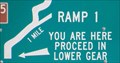 view gallery view gallerySW39.8 km |  Horseshoe Bend Hill Summit - Idaho Horseshoe Bend Hill Summit - Idaho
in 'You Are Here' Maps You Are Here marker at summit of Horseshoe Bend Hill, Idaho. posted by: Volcanoguy location: Idaho date approved: 02/21/2011 last visited: 04/12/2014 |
 view gallery view galleryS41.2 km |  Heinen (OZ1066) - Boise County, ID Heinen (OZ1066) - Boise County, ID
in U.S. Benchmarks Mt. Heinen USCGS Triangulation station posted by: BadSquirrel location: Idaho date approved: 09/28/2020 last visited: never |
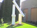 view gallery view gallerySW41.4 km |  40 40
in Abstract Public Sculptures From the right angle you can see a 4 posted by: cachegame location: Idaho date approved: 10/22/2006 last visited: 10/27/2008 |
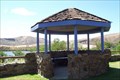 view gallery view gallery W46.5 km W46.5 km
|  Black Canyon Triangle Park, Emmett, Idaho Black Canyon Triangle Park, Emmett, Idaho
in Gazebos Triangle park is located on a hilltop with a beautiful view of the lake. The entire park can be rented for parties, receptions, etc. Gazebo is wood and steel with seating. There are 2 other day-use parks along Black Canyon resevoir. posted by: n2life location: Idaho date approved: 07/20/2009 last visited: never |
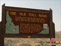 view gallery view galleryS46.7 km | The Old Toll Road - #266 in Idaho Historical Markers The Old Toll Road - Idaho Historical Sign# 266 posted by: Chooch72 location: Idaho date approved: 09/21/2007 last visited: 06/22/2012 |
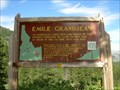 view gallery view galleryE48.8 km | Emile Grandjean #435 in Idaho Historical Markers An immigrant from Denmark where he had studied forestry, he came to this part of Idaho in 1883 to mine, hunt, and trap. posted by: Touchstone location: Idaho date approved: 06/25/2007 last visited: 06/03/2016 |
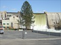 view gallery view galleryW50.1 km |  Black Canyon Dam - Emmett, ID Black Canyon Dam - Emmett, ID
in Man-made Waterfalls The Black Canyon Dam overflow. posted by: Phydux location: Idaho date approved: 04/19/2014 last visited: 05/10/2014 |
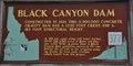 view gallery view galleryW50.2 km | Black Canyon Dam in Idaho Historical Markers This Idaho Historical Marker is located near the river's edge at the park just downstream from the dam and power plant. posted by: brwhiz location: Idaho date approved: 12/16/2013 last visited: 03/25/2016 |
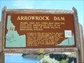 view gallery view galleryS50.7 km | Arrowrock Dam #376 in Idaho Historical Markers Higher than any dam from 1915 to 1934, Arrowrock Dam is still an essential part of Boise Valley's irrigation system. posted by: Touchstone location: Idaho date approved: 06/24/2007 last visited: 06/22/2012 |
|