 view gallery view gallery E6.4 km E6.4 km
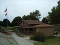
|   I-29 Southbound Mound City Rest Area I-29 Southbound Mound City Rest Area
in Highway Rest Areas Rest area Southbound I-29, 2 miles south of Route 118 and I-29, Mile Marker 82. posted by:  BruceS BruceS location: Missouri date approved: 09/26/2006 last visited: 06/04/2018 |
 view gallery view gallery SE8 km SE8 km
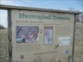
|  Bank Swallows - Mound City MO Bank Swallows - Mound City MO
in Flora and Fauna Information Signs There is a small protected area for Bank Swallows along US 159 about 4 miles south-southwest of Mound City, Missouri. posted by:  PeterNoG PeterNoG location: Missouri date approved: 05/06/2010 last visited: 10/09/2021 |
 view gallery view gallery S12.7 km S12.7 km
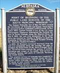
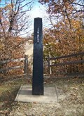
|  Point of Beginning Point of Beginning
in Nebraska Historical Markers This marker, located on the Nebraska-Kansas border, commemorates the starting point of the base line survey done in 1855-56 to mark the 40th parallel boundary between the two states. posted by: NevaP location: Nebraska date approved: 11/15/2007 last visited: 02/27/2023 |
 view gallery view galleryS12.7 km | Atchison-Nebraska railroad in Nebraska Historical Markers This is a handmade marker about the 19th century railroad that ran from Atchison, Kansas to Lincoln, Nebraska. posted by: NevaP location: Nebraska date approved: 11/18/2007 last visited: 09/05/2020 |
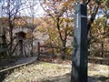 view gallery view galleryS12.7 km |  Survey monument -Point of Beginning Sixth Principal Meridian Survey monument -Point of Beginning Sixth Principal Meridian
in Guest Books This guestbook is at the 1855 monument marking the start of a survey line. posted by: NevaP location: Kansas date approved: 11/18/2007 last visited: 09/05/2020 |
 view gallery view galleryS12.7 km |  Point of Beginning of the Public Land Surveys of the Sixth Principal Meridian Point of Beginning of the Public Land Surveys of the Sixth Principal Meridian
in U.S. Historic Survey Stones and Monuments This monument marks the initial point of the 1855-56 survey of the border between the new territories of Kansas and Nebraska. posted by: NevaP location: Kansas date approved: 11/18/2007 last visited: 09/05/2020 |
 view gallery view gallery SW13.2 km SW13.2 km
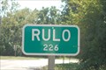
|  Rulo - Nebraska United States Rulo - Nebraska United States
in Population Signs A small town near the border of Nebraska and Missouri and Kansas. posted by: teeoff2 location: Nebraska date approved: 09/03/2010 last visited: 07/21/2012 |
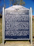 view gallery view gallerySW13.2 km | Missouri River in Nebraska Historical Markers This marker is near the Rulo Bridge across the Missouri River. posted by: NevaP location: Nebraska date approved: 11/13/2007 last visited: 08/24/2010 |
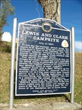 view gallery view gallerySW13.2 km | Lewis and Clark Campsite in Nebraska Historical Markers The marker tells of events July 12-13, 1804 when the Lewis and Clark expedition passed this location. posted by: NevaP location: Nebraska date approved: 11/13/2007 last visited: 08/24/2010 |
 view gallery view gallerySE18.5 km |  Zook and Roeker State Bank Zook and Roeker State Bank
in U.S. Benchmarks Can be found on the lower right hand door frame. posted by:  Troop81 Troop81 location: Missouri date approved: 07/18/2008 last visited: 10/15/2021 |
 view gallery view gallery N19.2 km N19.2 km
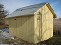
|  St. Oswald's-in-the-Fields Episcopal Church Outhouse - Skidmore, Missouri St. Oswald's-in-the-Fields Episcopal Church Outhouse - Skidmore, Missouri
in Outhouses Outhouse behind the St. Oswald's-in-the-Fields Episcopal Church in a rural area in vicinity of Skidmore, Missouri.
posted by: BruceS location: Missouri date approved: 12/11/2008 last visited: 06/09/2014 |
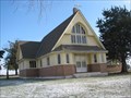
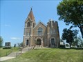
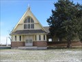 view gallery view galleryN19.2 km |  St. Oswald's-in-the-Fields Episcopal Church - Skidmore, Missouri St. Oswald's-in-the-Fields Episcopal Church - Skidmore, Missouri
in Anglican and Episcopal Churches Historic Episcopal church in a rural area in vicinity of Skidmore, Missouri. posted by: BruceS location: Missouri date approved: 12/11/2008 last visited: never |
 view gallery view galleryN19.2 km |  St. Oswald's-in-the-Fields Episcopal Church - Skidmore, Missouri St. Oswald's-in-the-Fields Episcopal Church - Skidmore, Missouri
in Country Churches Historic Episcopal church in a rural area in vicinity of Skidmore, Missouri. posted by: BruceS location: Missouri date approved: 12/14/2008 last visited: never |
 view gallery view galleryN19.2 km | St. Oswald's-in-the-Fields Episcopal Church - Skidmore, Missouri in This Old Church Historic Episcopal church in a rural area in vicinity of Skidmore, Missouri. posted by: BruceS location: Missouri date approved: 12/11/2008 last visited: never |
 view gallery view galleryN19.2 km |  St. Oswald's Protestant Episcopal Church - Skidmore, Missouri St. Oswald's Protestant Episcopal Church - Skidmore, Missouri
in U.S. National Register of Historic Places Historic Episcopal church also known as St. Oswald's-in-the-Fields Episcopal Church in a rural area in vicinity of Skidmore, Missouri.
posted by: BruceS location: Missouri date approved: 12/11/2008 last visited: never |
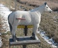 view gallery view galleryN25.4 km |  Horse Mail Box - Fairfax, Missouri Horse Mail Box - Fairfax, Missouri
in Themed Homemade Mailboxes Mail box in the shape of a horse in the vicinity of Fairfax, Missouri on Hwy 46.
posted by: BruceS location: Missouri date approved: 12/13/2008 last visited: never |
 view gallery view gallery W27 km W27 km
| Richardson County Courthouse in U.S. National Register of Historic Places The Richardson County Courthouse was built in 1924. posted by: NevaP location: Nebraska date approved: 11/12/2007 last visited: 09/10/2020 |
 view gallery view galleryW27 km |  Richardson County Courthouse, falls City, Nebraska Richardson County Courthouse, falls City, Nebraska
in Courthouses This Classic revival style courthouse was built in 1924. posted by: NevaP location: Nebraska date approved: 11/12/2007 last visited: 09/10/2020 |
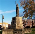 view gallery view galleryW27.2 km |  Statue of Liberty, Falls City, Nebraska Statue of Liberty, Falls City, Nebraska
in Exact Replicas This Lady Liberty, a boy scout donation, is in the courthouse square in Falls City, Nebraska posted by: NevaP location: Nebraska date approved: 11/25/2007 last visited: 06/22/2004 |
 view gallery view galleryW27.4 km |  M110A2 - 8 inch Self-propelled Artillery - Fall City, Nebraska M110A2 - 8 inch Self-propelled Artillery - Fall City, Nebraska
in Military Ground Equipment Displays Self-propelled artillery piece located in near American Legion in Fall City, Nebraska. posted by: BruceS location: Nebraska date approved: 05/28/2007 last visited: 09/06/2020 |
 view gallery view galleryW27.4 km |  M110A2 - 8 inch Self-propelled Artillery - Fall City, Nebraska M110A2 - 8 inch Self-propelled Artillery - Fall City, Nebraska
in Static Artillery Displays Self-propelled artillery piece located in near American Legion in Fall City, Nebraska. posted by: BruceS location: Nebraska date approved: 05/28/2007 last visited: never |
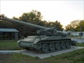
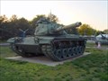 view gallery view galleryW27.4 km | M60 Tank - Fall City, Nebraska in Military Ground Equipment Displays M60 tank on display near American Legion in Fall City, Nebraska. posted by: BruceS location: Nebraska date approved: 05/28/2007 last visited: 09/06/2020 |
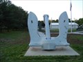 view gallery view galleryW27.4 km |  Navy Anchor - Fall City, Nebraska Navy Anchor - Fall City, Nebraska
in Anchors Large navy anchor near American Legion in Fall City, Nebraska. posted by: BruceS location: Nebraska date approved: 05/28/2007 last visited: 09/06/2020 |
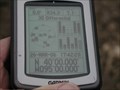 view gallery view gallerySE27.5 km |  N40 W95 2.2 miles SW of Fillmore, Andrew County, Missouri, USA N40 W95 2.2 miles SW of Fillmore, Andrew County, Missouri, USA
in Confluence Spots Another corn field posted by: txoilgas location: Missouri date approved: 01/16/2009 last visited: 03/26/2006 |
 view gallery view galleryW27.8 km | St. Paul's Lutheran Church - rural Richardson County, Nebraska in This Old Church This two-story rural church, part of the Missouri Synod, is located 6 miles north of Falls City, Ne, along US HWY 73. posted by: iconions location: Nebraska date approved: 06/30/2019 last visited: never |
|