 view gallery view gallery W2.7 km W2.7 km
|   Calvert County Survey Monument Map 46 Grid 5 Calvert County Survey Monument Map 46 Grid 5
in U.S. Benchmarks Solomons Island County triangulation disk posted by:  Saint Ro Saint Ro location: Maryland date approved: 04/24/2010 last visited: never |
 view gallery view galleryW2.7 km |  Enemy Blockade Star-Spangled Banner National Historic Trail - Solomons MD Enemy Blockade Star-Spangled Banner National Historic Trail - Solomons MD
in War of 1812 British warships blockaded the mouth of the Patuxent River after the Chesapeake Flotilla and Royal Navy skirmished off Cedar Point to the south June 1, 1814. posted by:  Don.Morfe Don.Morfe location: Maryland date approved: 03/19/2020 last visited: 11/02/2021 |
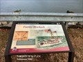 view gallery view galleryW2.7 km |  Enemy Blockade Star-Spangled Banner National Historic Trail - Solomons MD Enemy Blockade Star-Spangled Banner National Historic Trail - Solomons MD
in Signs of History British warships blockaded the mouth of the Patuxent River after the Chesapeake Flotilla and Royal Navy skirmished off Cedar Point to the south June 1, 1814. posted by: Don.Morfe location: Maryland date approved: 08/31/2022 last visited: 08/31/2022 |
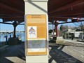
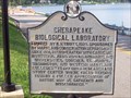 view gallery view galleryW2.7 km |  CHESAPEAKE BIOLOGICAL LABORATORY CHESAPEAKE BIOLOGICAL LABORATORY
in Maryland Historical Markers This marker sits in front of the Chesapeake Biological Laboratories in Solomon's Island, MD. posted by: redlights location: Maryland date approved: 07/01/2008 last visited: 11/11/2011 |
 view gallery view gallery NW3.4 km NW3.4 km
| Amphibious Training Base in Maryland Historical Markers Amphibious Training Base. The historical marker is displayed along the side of Dowell Road, just before entering Calvert Marina. posted by: redlights location: Maryland date approved: 06/19/2008 last visited: 07/09/2011 |
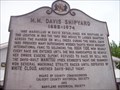 view gallery view galleryW3.4 km | M.M. Davis Shipyard in Maryland Historical Markers A historical marker on the east side of Route 2 in Solomons Island, Maryland. posted by: redlights location: Maryland date approved: 05/28/2007 last visited: never |
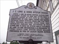 view gallery view galleryW3.5 km | J.C. Lore & Sons Oyster House in Maryland Historical Markers Another historical sign along the east side of Route 2, in front of the Calvert Marine Museum's exhibit at the Lore Oyster House. posted by: redlights location: Maryland date approved: 05/28/2007 last visited: 07/09/2011 |
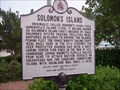 view gallery view galleryW3.5 km | Solomon's Island in Maryland Historical Markers A historical marker placed by the historical societies of Calvert County and Maryland. Looked on the west side of Route 2 just as you cross on the island. posted by: redlights location: Maryland date approved: 05/28/2007 last visited: 05/25/2017 |
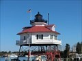 view gallery view galleryW3.9 km |  Drum Point Lighthouse - Solomons MD Drum Point Lighthouse - Solomons MD
in U.S. National Register of Historic Places The Drum Point Lighthouse is one of four remaining screwpile lighthouses on the Chesapeake Bay. Any lighthouse, and particularly a historic structure, is fast disappearing as navigational equipment due to the modern communications channels. posted by: Don.Morfe location: Maryland date approved: 10/05/2022 last visited: 10/04/2022 |
 view gallery view galleryW3.9 km |  Drum Point Light - Solomons, MD Drum Point Light - Solomons, MD
in Wikipedia Entries Drum Point Light is one of four surviving Chesapeake Bay screw-pile lighthouses. Originally located off Drum Point at the mouth of the Patuxent River, it is now an exhibit at the Calvert Marine Museum. posted by: Don.Morfe location: Maryland date approved: 10/04/2022 last visited: 10/04/2022 |
 view gallery view galleryW3.9 km | Drum Point Lighthouse - Solomons MD in Signs of History Drum Point Lighthouse was built in 1883 to mark the northern approach to the Patuxent River. It was originally located due south of Drum Point, 120 yards offshore, on five acres of submerged land conveyed by Maryland to the federal government. posted by: Don.Morfe location: Maryland date approved: 09/15/2020 last visited: 01/20/2022 |
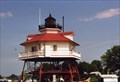 view gallery view galleryW4 km |  Drum Point Lighthouse Drum Point Lighthouse
in Coastal Lighthouses The Drum Point Lighthouse is open to the public with paid admission to the Calvert Marine Museum. But the lighthouse can be photographed without having to pay. Click the link below to view the Calvert Marine Museum's site. posted by: redlights location: Maryland date approved: 06/13/2008 last visited: 01/20/2022 |
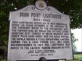 view gallery view galleryW4 km | Drum Point Lighthouse Historic Marker in Maryland Historical Markers Another historic marker along Route 2 leading into Solomons Island, Maryland. The marker is outside of the Calvert Marine Museum. Behind the marker a visitor can see the relocated and refurbished Drum Point screwpile lighthouse. posted by: redlights location: Maryland date approved: 05/28/2007 last visited: 11/11/2011 |
 view gallery view galleryW4 km | Menace on the Horizon Star-Spangled Banner National Historical Trail - Solomons MD in Signs of History Terror reigned along the Patuxent River in 1814. British invaders plundered and burned towns and plantations on both sides of the river. posted by: Don.Morfe location: Maryland date approved: 08/31/2022 last visited: 08/31/2022 |
 view gallery view galleryW4 km | Menace on the Horizon Star-Spangled Banner National Historical Trail - Solomons MD- in War of 1812 Terror reigned along the Patuxent River in 1814. British invaders plundered and burned towns and plantations on both sides of the river. posted by: Don.Morfe location: Maryland date approved: 03/15/2020 last visited: 11/02/2021 |
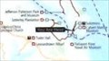 view gallery view galleryW4 km |  'You Are Here' Maps-Menace on the Horizon - Solomons MD 'You Are Here' Maps-Menace on the Horizon - Solomons MD
in 'You Are Here' Maps 'You Are Here' Map shows that you are on the grounds of the Calvert Marine Museum in front of the main exhibition hall, 14200 Solomons Island Road South, Solomons, MD United States 20688. posted by: Don.Morfe location: Maryland date approved: 09/13/2023 last visited: 09/13/2023 |
 view gallery view galleryW4 km |  Menace on the Horizon - Solomons MD Menace on the Horizon - Solomons MD
in Battlefields The marker is located on the grounds of the Calvert Marine Museum in front of the main exhibition hall, 14200 Solomons Island Road South, Solomons, MD United States 20688. posted by: Don.Morfe location: Maryland date approved: 09/15/2023 last visited: 09/15/2023 |
 view gallery view galleryW4 km | Calvert Marine Museum - Solomons Island MD in Wikipedia Entries The Calvert Marine Museum is a maritime museum located in Solomons, Maryland. The museum has three main themes: regional paleontology, estuarine life of the Patuxent River and Chesapeake Bay, maritime history. posted by: Don.Morfe location: Maryland date approved: 01/19/2022 last visited: 01/20/2022 |
 view gallery view galleryW4 km |  Calvert Marine Museum - Solomons Island MD Calvert Marine Museum - Solomons Island MD
in Official Local Tourism Attractions The Calvert Marine Museum is a maritime museum located in Solomons, Maryland. The museum has three main themes: regional paleontology,
estuarine life of the Patuxent River and Chesapeake Bay,
maritime history. posted by: Don.Morfe location: Maryland date approved: 01/19/2022 last visited: 01/20/2022 |
 view gallery view galleryW4 km |  Calvert Marine Museum - Solomons Island MD Calvert Marine Museum - Solomons Island MD
in Maritime Museums The Calvert Marine Museum is a maritime museum located in Solomons, Maryland. The museum has three main themes: regional paleontology, estuarine life of the Patuxent River and Chesapeake Bay, maritime history. posted by: Don.Morfe location: Maryland date approved: 01/19/2022 last visited: 01/20/2022 |
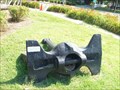 view gallery view galleryW4.2 km |  Anchor - USS Valcour Anchor - USS Valcour
in Anchors This anchor sits on the property of the Solomon's Island Visitor Center, in Solomons, MD. posted by: redlights location: Maryland date approved: 07/14/2008 last visited: 03/02/2010 |
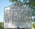 view gallery view galleryW4.2 km | CALVERT COUNTY (no. 2) in Maryland Historical Markers This historical marker is located across from the Visitors Center in Solomons, MD. There is room to park very close by or you can park in the Visitor Center's lot. posted by: redlights location: Maryland date approved: 07/11/2008 last visited: 08/21/2021 |
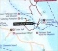 view gallery view galleryW4.2 km | 'You Are Here' Maps-Perils along the Patuxent Star - Solomons MD in 'You Are Here' Maps The 'You Are Here' Map shows that you are on the grounds of the Solomons Island Visitor Center, Solomons Island Road, Solomons, MD United States
20688 posted by: Don.Morfe location: Maryland date approved: 09/13/2023 last visited: 09/13/2023 |
 view gallery view galleryW4.2 km | Perils along the Patuxent - Solomons MD in Battlefields The marker is located on the grounds of the Solomons Island Visitor Center, Solomons Island Road, Solomons, MD United States 20688 posted by: Don.Morfe location: Maryland date approved: 09/15/2023 last visited: 09/15/2023 |
 view gallery view galleryW4.2 km | Perils along the Patuxent Star-Spangled Banner National Historic Trail - Solomons MD in War of 1812 Southern Maryland was a dangerous place to live in the hot summer of 1814. British raiding parties traveled the Patuxent River and swept through the countryside terrorizing civilians and taking provisions for British troops gathering in the area. posted by: Don.Morfe location: Maryland date approved: 03/14/2020 last visited: 11/02/2021 |
|