 view gallery view gallery NE0.2 km NE0.2 km
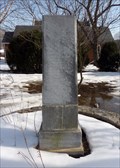
|   Frank Padget Water Tragedy - Glasgow, VA Frank Padget Water Tragedy - Glasgow, VA
in Maritime Monuments and Memorials Memorial to Frank Padget, an African-American slave who perished in 1854 while saving others from a canal boat in the James River. posted by:  SportsPhotoGuy SportsPhotoGuy location: Virginia date approved: 02/21/2010 last visited: 01/24/2011 |
 view gallery view gallery SE0.3 km SE0.3 km
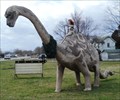
|  Apotasaurus - Glasgow, VA Apotasaurus - Glasgow, VA
in Dinosaur Statues A rememant from "The Town That Time Forgot" exhibit still roams Glasgow... posted by:  vhasler vhasler location: Virginia date approved: 03/28/2012 last visited: never |
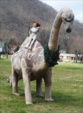 view gallery view gallerySE0.3 km |  The Town That Time Forgot - Glasgow, VA The Town That Time Forgot - Glasgow, VA
in Roadside Attractions A survior from the almost extinct "The Town That Time Forgot" exhibit created in 2003... posted by: vhasler location: Virginia date approved: 03/25/2012 last visited: never |
 view gallery view gallery SW0.8 km SW0.8 km
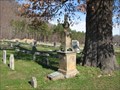
|  John Paxton John Paxton
in American Revolutionary War Veteran Graves Revolutionary War Veteran John Paxton is buried in the Glasgow/Paxton Cemetery in Glasgow, Virginia posted by: Sneakin Deacon location: Virginia date approved: 11/29/2006 last visited: never |
 view gallery view gallery E1.1 km E1.1 km
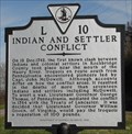
|  Indian and Settler Conflict Indian and Settler Conflict
in Virginia Historical Markers This historic marker is located near the Maury River where the first conflict between the Indians and Settlers in Rockbridge County took place. posted by: Sneakin Deacon location: Virginia date approved: 12/14/2006 last visited: 09/08/2011 |
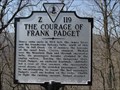 view gallery view gallerySE3.4 km | The Courage of Frank Padget in Virginia Historical Markers This historic marker is located on Route 501 at the Rockbridge - Amherst County Line. posted by: Sneakin Deacon location: Virginia date approved: 03/08/2009 last visited: 02/21/2010 |
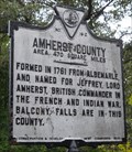 view gallery view gallerySE3.4 km | Amherst County/Rockbridge County in Virginia Historical Markers County line marker on twisty US501 posted by: vhasler location: Virginia date approved: 09/07/2011 last visited: never |
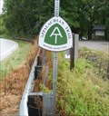
 view gallery view gallerySE5 km |  Matts Creek Shelter, AT Nr Snowden, VA, James River Face Wilderness Matts Creek Shelter, AT Nr Snowden, VA, James River Face Wilderness
in Appalachian Trail We took a break at the Matts Creek Shelter on the AT during a September 2008 weekend backpacker. posted by: garmin_geek location: Virginia date approved: 01/27/2009 last visited: 09/20/2008 |
 view gallery view gallery S5.3 km S5.3 km
| AT Intersection To Devil's Marbleyard, Nr Snowden, VA in Appalachian Trail Intersection signpost for trail leading off AT to down hike to the Devil's Marbleyard. September 2008 posted by: garmin_geek location: Virginia date approved: 01/22/2009 last visited: 09/20/2008 |
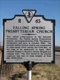
 view gallery view gallery N5.8 km N5.8 km
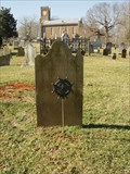
|  Falling Springs Presbyterian Church - Glasgow, Virginia Falling Springs Presbyterian Church - Glasgow, Virginia
in This Old Church The Falling Spring Presbyterian Church was founded about 1748, the current building was dedicated in 1864. posted by: Sneakin Deacon location: Virginia date approved: 01/29/2007 last visited: never |
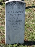 view gallery view galleryN5.8 km | Alexander McNutt in American Revolutionary War Veteran Graves A veteran of the Revolutionary War who lived the later years of his life in Rockbridge County, Virginia posted by: Sneakin Deacon location: Virginia date approved: 01/31/2007 last visited: never |
 view gallery view galleryN5.8 km | John Grigsby in American Revolutionary War Veteran Graves John Grigsby was one of the early settlers of the Shenandoah Valley and a veteran of the Revolutionary War posted by: Sneakin Deacon location: Virginia date approved: 01/31/2007 last visited: never |
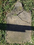 view gallery view galleryN5.8 km | William Paxton in American Revolutionary War Veteran Graves William Paxton was one of the early settler of Rockbridge County and a Veteran of Revolutionary War posted by: Sneakin Deacon location: Virginia date approved: 01/31/2007 last visited: never |
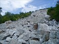 view gallery view galleryS6.1 km |  Devil's Marbleyard, VA Devil's Marbleyard, VA
in Places of Geologic Significance Jefferson National Forest. Devil’s Marbleyard offers unforgettable impression of huge house size boulders tossed about the ridgeline and amazing view of the valley below. Worth the hike up from road below or down from the AT on the ridgeline above. posted by: garmin_geek location: Virginia date approved: 01/21/2009 last visited: 08/16/2007 |
 view gallery view galleryS6.1 km | AT In James River Face Wilderness, Nr Snowden, VA in Appalachian Trail Appalachian Trail sign post in the James River Face Wilderness posted by: garmin_geek location: Virginia date approved: 01/22/2009 last visited: 09/20/2008 |
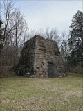 view gallery view gallerySW6.3 km |  Glenwood Furnace - Natural Bridge Station, Virginia Glenwood Furnace - Natural Bridge Station, Virginia
in Iron Furnace Ruins Located on the northbound side of Arnold's Valley Road. posted by: flyingmoose location: Virginia date approved: 01/28/2023 last visited: never |
 view gallery view gallerySE6.4 km | AT, Northbound Sign Crossing Hwy 812, Nr Snowden, VA in Appalachian Trail AT northbound crossing of VA Hwy 812, near Snowden, VA. posted by: garmin_geek location: Virginia date approved: 01/22/2009 last visited: 09/19/2008 |
 view gallery view gallerySE6.8 km | AT foot bridge across James River - Snowden, VA in Appalachian Trail The AT sign marks the parking lot for the 625 ft bridge across the James River - which was dedicated in 2000. posted by: vhasler location: Virginia date approved: 09/18/2011 last visited: 06/23/2014 |
 view gallery view gallerySE6.8 km |  James River footbridge opens - Snowden, VA James River footbridge opens - Snowden, VA
in News Article Locations The Applachian Trail (AT) is greatly improved by the opening of a 625 ft bridge across the James River. posted by: vhasler location: Virginia date approved: 09/17/2011 last visited: 06/23/2014 |
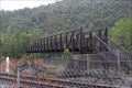 view gallery view gallerySE6.8 km |  AT bridge across James River - Snowden, VA AT bridge across James River - Snowden, VA
in Truss Bridges The Applachian Trail (AT) cross the James River on a 625 ft truss bridge dedicated in October 2000. posted by: vhasler location: Virginia date approved: 09/17/2011 last visited: 06/23/2014 |
 view gallery view gallerySE6.8 km |  Appalachian Trail Bridge, James River, VA Appalachian Trail Bridge, James River, VA
in Hiking Path Footbridges Appalachian Trail (AT) bridge crossing the James River near Snowden, VA. U.S. 501 posted by: garmin_geek location: Virginia date approved: 01/22/2009 last visited: 06/23/2014 |
 view gallery view gallery NW6.9 km NW6.9 km
| Falling Springs Presbyterian Church in Virginia Historical Markers The Falling Springs Presbyterian Church was founded in the 1700's. posted by: Sneakin Deacon location: Virginia date approved: 01/29/2007 last visited: 08/14/2021 |
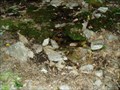 view gallery view galleryS6.9 km |  Marble Springs, James River Face Wilderness, Appalachian Trail, VA Marble Springs, James River Face Wilderness, Appalachian Trail, VA
in Natural Springs Marble springs is a water source and camp site on the AT in the James River Face Wilderness posted by: garmin_geek location: Virginia date approved: 01/26/2009 last visited: 09/20/2008 |
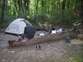 view gallery view galleryS7.1 km | Marble Springs Campsite, AT Nr Snowden, VA, James River Face Wilderness in Appalachian Trail Marble Springs campsite. Some maps indicated it was a shelter. Established AT campsite with water. No shelter. posted by: garmin_geek location: Virginia date approved: 02/03/2009 last visited: 09/20/2008 |
 view gallery view gallery W7.2 km W7.2 km
|  Natural Bridge Zoo, VA Natural Bridge Zoo, VA
in Zoos Small collection of exotic animals to visit. posted by: vhasler location: Virginia date approved: 12/17/2011 last visited: 08/29/2016 |
|