 view gallery view gallery S7.2 km S7.2 km
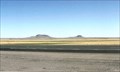
|   Rabbit Ears (Clayton Complex) ~ Clayton, NM Rabbit Ears (Clayton Complex) ~ Clayton, NM
in U.S. National Register of Historic Places Named after and old Indian Chief, and a famous landmark on the Santa Fe Trail. posted by:  YoSam. YoSam. location: New Mexico date approved: 07/13/2009 last visited: 05/06/2012 |
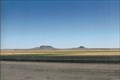 view gallery view galleryS7.2 km |  Rabbit Ears - Clayton, New Mexico Rabbit Ears - Clayton, New Mexico
in Wikipedia Entries Used as a guide post for both the early Spanish and the Santa Fe merchants. posted by: YoSam. location: New Mexico date approved: 08/06/2016 last visited: never |
 view gallery view gallery NW9.2 km NW9.2 km
|  Grandview Cemetery - Clayton, NM Grandview Cemetery - Clayton, NM
in Worldwide Cemeteries A small desert cemetery in Union County, New Mexico posted by: The Snowdog location: New Mexico date approved: 07/09/2020 last visited: never |
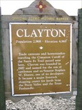 view gallery view galleryS13.8 km |  Clayton Clayton
in New Mexico Historical Markers West of town and invitin' you in. posted by: YoSam. location: New Mexico date approved: 07/07/2009 last visited: 04/06/2023 |
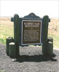 view gallery view galleryS13.8 km | Rabbit Ear Mountain in New Mexico Historical Markers First landmark to aid travel since leaving Oklahoma on the Santa Fe Trail. posted by: YoSam. location: New Mexico date approved: 07/07/2009 last visited: 10/30/2021 |
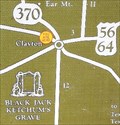 view gallery view galleryS13.8 km |  Points of Interest ~ Clayton, NM Points of Interest ~ Clayton, NM
in 'You Are Here' Maps Rabbit Ear Mountains, a Santa Fe Trail landmark. posted by: YoSam. location: New Mexico date approved: 07/08/2009 last visited: 04/06/2023 |
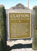
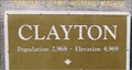
 view gallery view galleryS13.8 km |  Clayton, New Mexico - Population: 2,968 Clayton, New Mexico - Population: 2,968
in Population Signs Western city limits of Clayton posted by: YoSam. location: New Mexico date approved: 08/07/2016 last visited: 04/06/2023 |
 view gallery view galleryS13.8 km |  Clayton New Mexico - 4,969 feet Clayton New Mexico - 4,969 feet
in Elevation Signs West of town and invitin' you in. posted by: YoSam. location: New Mexico date approved: 08/06/2016 last visited: 04/06/2023 |
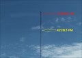 view gallery view galleryS15.3 km |  K219LT-FM 91.7 (KBKN) & K228DP-FM 93.5 (KENW) -- Clayton NM USA K219LT-FM 91.7 (KBKN) & K228DP-FM 93.5 (KENW) -- Clayton NM USA
in Radio and Television Transmitter Towers Two low-power FM translators broadcast distant stations to listeners in Clayton NM from this tower along the US64/87 just outside the city limit of Clayton NM posted by: Benchmark Blasterz location: New Mexico date approved: 01/29/2023 last visited: 01/30/2023 |
 view gallery view galleryS15.8 km |  Santa Fe Trail National Scenic Byway - Clayton, NM Santa Fe Trail National Scenic Byway - Clayton, NM
in National Scenic Byways This marker indicates that you are on the Santa Fe Trail National Scenic Byway - in Clayton, New Mexico. posted by: The Snowdog location: New Mexico date approved: 09/11/2023 last visited: never |
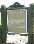
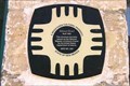
 view gallery view galleryS15.8 km |  The Santa Fe Trail - Clayton, NM The Santa Fe Trail - Clayton, NM
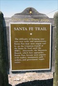
in Wagon Roads and Trails One of several markers at a road side pull out on the north side of Highway 64 - east of Clayton, New Mexico. posted by: The Snowdog location: New Mexico date approved: 09/12/2023 last visited: never |
 view gallery view galleryS15.8 km | You Are Here - The Santa Fe Trail - Clayton, NM in 'You Are Here' Maps This You Are Here map is in a cluster of historical markers on the north side of Highway 64, just east of Clayton, New Mexico. posted by: The Snowdog location: New Mexico date approved: 09/11/2023 last visited: never |
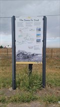 view gallery view galleryS15.8 km | The Santa Fe Trail - Clayton, NM in New Mexico Historical Markers One of several markers at a road side pull out on the north side of Highway 64 - east of Clayton, New Mexico. posted by: The Snowdog location: New Mexico date approved: 09/12/2023 last visited: never |
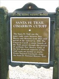 view gallery view galleryS15.8 km | Santa Fe Trail - Cimarron Cutoff in New Mexico Historical Markers East of Clayton, NM where the Santa Fe Trail was vital in forming the city. posted by: YoSam. location: New Mexico date approved: 07/08/2009 last visited: 09/10/2023 |
 view gallery view galleryS15.8 km | Clayton in New Mexico Historical Markers On the east side of town. posted by: YoSam. location: New Mexico date approved: 07/07/2009 last visited: 09/10/2023 |
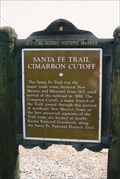 view gallery view galleryS15.8 km | Santa Fe Trail - Cimarron Cutoff - Clayton, NM in Wagon Roads and Trails The Cimarron Route was shorter and more suited to wagon travel, and it shortened the traveling time by ten days. posted by: YoSam. location: New Mexico date approved: 11/14/2013 last visited: 09/10/2023 |
 view gallery view galleryS15.8 km | Clayton, New Mexico - 4,969 Feet in Elevation Signs East city limits, roadside turnout posted by: YoSam. location: New Mexico date approved: 08/06/2016 last visited: 09/11/2023 |
 view gallery view galleryS15.8 km | Clayton, New Mexico - Population: 2,968 in Population Signs East limits of Clayton, on the plateau posted by: YoSam. location: New Mexico date approved: 08/07/2016 last visited: 09/10/2023 |
 view gallery view galleryS15.8 km | Santa Fe Trail - Clayton, NM in Wagon Roads and Trails The Santa Fe trail opened the west, and to get to Frankilin, MO - where it started - pioneers had to use the the Red Feather Trail from St. Louis to San Carlos (St. Charles, MO) then the Boones Lick Trail from the Missouri River to Franklin, MO. posted by: YoSam. location: New Mexico date approved: 12/19/2013 last visited: 09/10/2023 |
 view gallery view galleryS15.8 km | Santa Fe Trail in New Mexico Historical Markers It starts on the banks of the Missouri River in St. Charles, called the "Boone's Lick Trail", which goes to Franklin, MO; then the Santa Fe Trail takes over and led pioneers to their dreams. posted by: YoSam. location: New Mexico date approved: 07/09/2009 last visited: 09/10/2023 |
 view gallery view galleryS16.1 km | Eklund Hotel - Clayton, NM in New Mexico Historical Markers State of Mexico marker, this one has less history than most. posted by: YoSam. location: New Mexico date approved: 04/02/2019 last visited: 10/20/2023 |
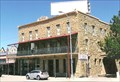
 view gallery view galleryS16.1 km |  1905 - Hotel Eklund ~ Clayton, NM 1905 - Hotel Eklund ~ Clayton, NM
in Dated Buildings and Cornerstones Carl Eklund, a Swedish immigrant bought the beginnings of a hotel in 1894, then.... posted by: YoSam. location: New Mexico date approved: 07/07/2009 last visited: 10/20/2023 |
 view gallery view galleryS16.1 km | Eklund Hotel - Clayton, NM in U.S. National Register of Historic Places Black Jack Ketchum and a herd of Texas cowboys made this place exciting. posted by: YoSam. location: New Mexico date approved: 07/07/2009 last visited: 10/20/2023 |
 view gallery view galleryS16.1 km |  Eklund Hotel - 1892 - Clayton, NM Eklund Hotel - 1892 - Clayton, NM
in Dated Architectural Structures Multifarious Building built in 1892, third floor added in 1905. posted by: YoSam. location: New Mexico date approved: 04/02/2019 last visited: 10/20/2023 |
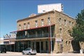 view gallery view galleryS16.1 km |  Eklund Hotel - Clayton, NM Eklund Hotel - Clayton, NM
in People-Named Places Historic hotel has been a land mark and safe haven for travelers since the 1800's. posted by: YoSam. location: New Mexico date approved: 05/22/2023 last visited: 10/20/2023 |
|