 view gallery view gallery SW2.4 km SW2.4 km
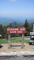
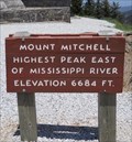
|   Mount Mitchell Parking Lot, 6,578 Feet Mt. Mitchell, North Carolina Mount Mitchell Parking Lot, 6,578 Feet Mt. Mitchell, North Carolina
in Elevation Signs A sign posting the elevation of the parking lot found near the summit of Mount Mitchell in North Carolina. Mount Mitchell is the highest peak in the United States found East of the Mississippi River. posted by:  PersonsMD PersonsMD location: North Carolina date approved: 05/24/2011 last visited: 05/24/2017 |
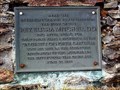
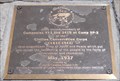 view gallery view gallerySW2.4 km |  Camp SP-2 of the CCC, Mount Mitchell, North Carolina Camp SP-2 of the CCC, Mount Mitchell, North Carolina
in Civilian Conservation Corps A monument to the members of Companies 413 and 2410 at Camp SP-2 of the Civilian Conservation Corps located near the summit of Mount Mitchell, North Carolina. posted by: PersonsMD location: North Carolina date approved: 05/30/2011 last visited: 08/27/2018 |
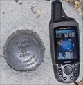 view gallery view gallerySW2.6 km |  Black Bear 2008 Black Bear 2008
in U.S. Benchmarks The Black Beark Horizontal Control Mark can be found in the upper parking lot at the Mount Mitchell visitor center. posted by: PersonsMD location: North Carolina date approved: 05/26/2011 last visited: 08/27/2018 |
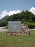
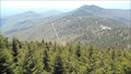 view gallery view gallerySW2.6 km |  Mount Mitchell State Park - Mount Mitchell, North Carolina Mount Mitchell State Park - Mount Mitchell, North Carolina
in U.S. National Natural Landmarks Located just off of the Famous Blue Ridge Parkway, Mount Mitchell State Park provides visitors with breathtaking views of the Blue Ridge Mountains; historical insight into early American heritage and ample opportunities to commune with nature. posted by: PersonsMD location: North Carolina date approved: 05/24/2011 last visited: 10/04/2023 |
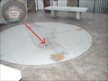
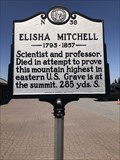 view gallery view gallerySW2.6 km |  Elisha Mitchell N-38 Elisha Mitchell N-38
in North Carolina Historical Markers Located in the parking lot on top of Mount Mitchell. posted by: flyingmoose location: North Carolina date approved: 03/05/2023 last visited: 10/05/2023 |
 view gallery view gallerySW2.6 km |  Mount Mitchell State Park - Burnsville, North Carolina Mount Mitchell State Park - Burnsville, North Carolina
in State/Provincial Parks The tallest mountain peak East of the Mississippi River is Mt. Mitchell, in North Carolina. posted by: BarbershopDru location: North Carolina date approved: 07/22/2010 last visited: 10/04/2023 |
 view gallery view gallerySW2.6 km | Mt. Mitchell, NC Geodetic in U.S. Benchmarks Geodetic Survey Benchmark found on the Basalm Nature Trail Near the Peak of Mount Mitchell, NC. posted by: JensenFamily05 location: North Carolina date approved: 10/23/2010 last visited: 08/12/2011 |
 view gallery view gallerySW2.6 km |  Mt. Mitchell Mt. Mitchell
in Mountain Summits Mt. Mitchell, the highest peak east of the Mississippi River, is named for Dr. Elisha Mitchell, a professor of sciences at UNC-Chapel Hill who first suggested that the peak that bears his name was the highest in the Black Mountain range. Dr. Mitchell died at a waterfall on the western slope of the mountain while returning from one of many exploratory trips to western North Carolina. posted by: ScubaDewd location: North Carolina date approved: 04/03/2006 last visited: 10/04/2023 |
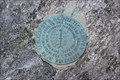
 view gallery view gallerySW2.7 km | MOUNT MITCHELL (NC) in U.S. Benchmarks Special disk atop Mount Mitchell. posted by: PFF location: North Carolina date approved: 08/25/2009 last visited: 10/04/2023 |
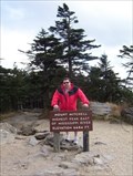
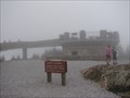 view gallery view gallerySW2.7 km |  Mount Mitchell (NC) Observation Tower Mount Mitchell (NC) Observation Tower
in Look-Out Towers Observation platform built in 2009 to replace an aging stone structure with steep, narrow steps. Located on the highest point in the Eastern United States. posted by: PFF location: North Carolina date approved: 08/25/2009 last visited: 10/04/2023 |
 view gallery view gallerySW2.7 km |  Dr. Elisha Mitchell Dr. Elisha Mitchell
in Grave of a Famous Person Elisha Mitchell surveyed the highest peak east of the Mississippi River, Mt. Mitchell. posted by: ScubaDewd location: North Carolina date approved: 05/27/2006 last visited: 10/04/2023 |
 view gallery view gallerySW2.7 km |  HIGHEST - Mountain Peak East of the Mississippi River, Mt. Mitchell HIGHEST - Mountain Peak East of the Mississippi River, Mt. Mitchell
in Superlatives Mount Mitchell is the HIGHEST peak in the United Staets East of the Mississippi River. Standing at 6,684 feet and located in Mount Mitchell State Park just off of the Blue Ridge Parkway in North Carolina. posted by: PersonsMD location: North Carolina date approved: 05/24/2011 last visited: 10/04/2023 |
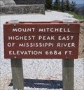 view gallery view gallerySW2.7 km | Summit of Mount Mitchell - 6,684 Feet, Mt. Mitchell State Park, North Carolina in Elevation Signs Sign found at the summit of Mount Mitchell in Mount Mitchell State Park in North Carolina noting the elevation of 6,684 feet, the highest point in the United States East of the Mississippi River. posted by: PersonsMD location: North Carolina date approved: 05/24/2011 last visited: 10/04/2023 |
 view gallery view gallery NE9.7 km NE9.7 km
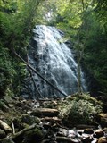
|  "Crabtree Falls" - Blue Ridge Parkway, North Carolina "Crabtree Falls" - Blue Ridge Parkway, North Carolina
in Waterfalls A wonderful stop at mile marker 339.5 along the Blue Ridge Parkway. posted by: BarbershopDru location: North Carolina date approved: 07/22/2010 last visited: never |
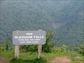 view gallery view gallerySW10.3 km |  GLASSMINE FALLS. Blue Ridge Parkway (NC) GLASSMINE FALLS. Blue Ridge Parkway (NC)
in Scenic Roadside Look-Outs Scenic Overlook, with view of 800-foot high Glassmine Falls. posted by: PFF location: North Carolina date approved: 08/27/2009 last visited: 05/16/2023 |
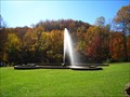
 view gallery view gallery S14.6 km S14.6 km
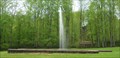
|  Andrews Geyser, Old Fort, North Carolina Andrews Geyser, Old Fort, North Carolina
in Wikipedia Entries This manmade geyser was built in 1885 as a memorial to the workers who gave their lives to build the railroad between Old Fort and Asheville became a major tourist attraction in the area. It shoots water continuously to a height of 80 feet. posted by: PersonsMD location: North Carolina date approved: 05/21/2011 last visited: 08/30/2022 |
 view gallery view galleryS14.6 km |  Andrews Geyser, Old Fort, North Carolina Andrews Geyser, Old Fort, North Carolina
in Fountains This manmade geyser was built in 1885 as a memorial to the workers who gave their lives to build the railroad between Old Fort and Asheville became a major tourist attraction in the area. It shoots water continuously to a height of 80 feet. posted by: PersonsMD location: North Carolina date approved: 05/14/2011 last visited: 08/29/2022 |
 view gallery view galleryS14.6 km |  Swannanoa Gap Engagement - Old Fort, NC Swannanoa Gap Engagement - Old Fort, NC
in Civil War Discovery Trail Sites Trails sign located at Andrews Geyser Park describes engangement on April 20 and 21, 1865 in which confederates effectually blocked and defended this mountain passage from Stoneman's raiders en route to Asheville, NC. posted by:  geodave88 geodave88 location: North Carolina date approved: 11/24/2008 last visited: 08/30/2022 |
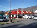 view gallery view gallery N15.8 km N15.8 km
|  McDonald's -- Burnsville, NC McDonald's -- Burnsville, NC
in McDonald's Restaurants The Burnsville, NC McDonald's. posted by: papermanone & catlover location: North Carolina date approved: 01/02/2007 last visited: 07/10/2007 |
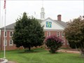 view gallery view galleryN15.8 km |  Yancey County Courthouse, Burnsville NC Yancey County Courthouse, Burnsville NC
in Courthouses The Yancey County Courthouse at the southeast corner of the town square is the county seat and courthouse. This is a relatively new courthouse, built in 1968 to replace the historic courthouse built in 1908. The old courthouse is now the town hall. posted by: arby101ca location: North Carolina date approved: 08/29/2012 last visited: 05/18/2013 |
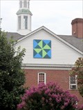 view gallery view galleryN15.8 km |  Courthouse Steps Quilt, Burnsville NC Courthouse Steps Quilt, Burnsville NC
in Painted Barn Quilts Above the entrance to the Yancey County Courthouse in Burnsville is a fine quilt block. The pattern is appropriate, "Courthouse Steps" posted by: arby101ca location: North Carolina date approved: 08/28/2012 last visited: 05/18/2013 |
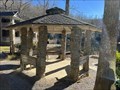 view gallery view galleryS15.8 km |  Lake Susan Gazebo - Montreat, North Carolina Lake Susan Gazebo - Montreat, North Carolina
in Gazebos A gazebo located in Montreat, North Carolina. posted by: dream chaser location: North Carolina date approved: 12/17/2021 last visited: never |
 view gallery view galleryN15.8 km |  Memorial Obelisk, Burnsville NC Memorial Obelisk, Burnsville NC
in Obelisks In front of the Yancey County Courthouse is an obelisk, about 12 ft high. This is a war memorial for Yancey County residents who died in 20th century wars, WW I, WW II, Korea and Viet Nam. posted by: arby101ca location: North Carolina date approved: 08/28/2012 last visited: never |
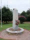 view gallery view galleryN15.8 km |  Yancey County War Memorial, Burnsville NC Yancey County War Memorial, Burnsville NC
in Non-Specific Veteran Memorials The memorial for Yancey County residents who died in 20th century wars, WW I, WW II, Korea and Viet Nam is in front of the Yancey County Courthouse. The memorial is an obelisk, about 12 ft high. with names on all four sides. posted by: arby101ca location: North Carolina date approved: 09/01/2012 last visited: never |
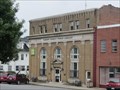 view gallery view galleryN15.8 km |  Citizens Bank Building - Burnsville, NC Citizens Bank Building - Burnsville, NC
in U.S. National Register of Historic Places There are several historic buildings on the town square of Burnsville, NC, including the Citizens Bank Building, Circa 1925, # 90000545 in the Registry. posted by: arby101ca location: North Carolina date approved: 08/28/2012 last visited: 08/20/2014 |
|