 view gallery view gallery NW1.9 km NW1.9 km
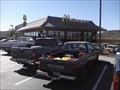
|   Mayer / Cordes Junction McDonald's Mayer / Cordes Junction McDonald's
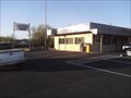
in McDonald's Restaurants A nice McDonald's that more-or-less acts as a rest stop for travelers along I-17. It is located where I-17 and Hwy 69 (to Prescott) intersect. posted by:  Where's George Where's George location: Arizona date approved: 11/09/2011 last visited: 09/30/2012 |
 view gallery view gallery S8.4 km S8.4 km
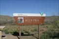
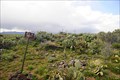
|  Agua Fria National Monument & BLM Land - Cordes Junction, AZ Agua Fria National Monument & BLM Land - Cordes Junction, AZ
in Public Access Lands The Agua Fria National Monument contains more than 400 archaeological sites, spanning some 2,000 years of human history. The area is BLM land and is open to the public as recreation land, including camping, hunting, and off-roading. posted by: DopeyDuck location: Arizona date approved: 04/10/2009 last visited: 12/20/2017 |
 view gallery view gallery N13.4 km N13.4 km
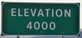
|  Interstate 17 Southbound ~ Elevation 4000 Feet Interstate 17 Southbound ~ Elevation 4000 Feet
in Elevation Signs This Elevation Sign is in the mountains southwest of Camp Verde, Arizona on Interstate 17. posted by:  brwhiz brwhiz location: Arizona date approved: 09/07/2012 last visited: 08/12/2019 |
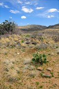
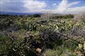 view gallery view galleryS13.7 km |  Pueblo Pato, Hohokam Nation, Perry Mesa, Arizona (047) Pueblo Pato, Hohokam Nation, Perry Mesa, Arizona (047)
in New World Ancient Evidence Located on the Perry Mesa on the south edge of Perry Tank Canyon posted by: CoinsAndPins location: Arizona date approved: 12/08/2009 last visited: 01/26/2018 |
 view gallery view galleryS13.8 km | Pueblo Pato, Hohokam Nation, Perry Mesa, Arizona (046) in New World Ancient Evidence Located on Perry Mesa near the Perry Tank Canyon. posted by: CoinsAndPins location: Arizona date approved: 12/08/2009 last visited: 01/28/2018 |
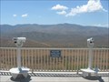 view gallery view galleryS14.3 km |  Sunset Point I-17, Arizona Sunset Point I-17, Arizona
in Coin-Op Binoculars A beautiful view from a popular rest area on I-17 in Arizona. posted by: desert georangers location: Arizona date approved: 07/22/2010 last visited: 09/07/2018 |
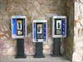 view gallery view galleryS14.3 km |  Sunset Point Rest Area Pay Phone Sunset Point Rest Area Pay Phone
in Payphones Three payphones are located side-by-side-by-side at the Sunset Point Rest Area on Highway 17 in Arizona. posted by: Fremont Claassens location: Arizona date approved: 07/09/2006 last visited: 09/07/2018 |
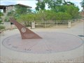 view gallery view galleryS14.3 km |  Sunset Point Rest Area Sundial Sunset Point Rest Area Sundial
in Sundials A memorial sundial located in the Sunset Point Rest Area on Highway 17 in Arizona. posted by: Fremont Claassens location: Arizona date approved: 07/09/2006 last visited: 02/17/2018 |
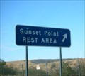 view gallery view galleryS14.3 km |  I-17 - Sunset Point Rest Area - Arizona I-17 - Sunset Point Rest Area - Arizona
in Highway Rest Areas Sunset Point Rest Area. A welcome respite from the long days travel. posted by: geobwong2k location: Arizona date approved: 09/06/2011 last visited: 08/12/2019 |
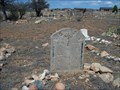
 view gallery view galleryNW15.3 km |  Mayer Cemetery - Mayer, Arizona, USA Mayer Cemetery - Mayer, Arizona, USA
in Worldwide Cemeteries This cemetery began in 1907. posted by:  Tsegi Mike and Desert Viking Tsegi Mike and Desert Viking location: Arizona date approved: 09/23/2011 last visited: never |
 view gallery view galleryNW15.6 km |  Holsum Bread - Mayer, AZ Holsum Bread - Mayer, AZ
in Ghost Signs This advertisement for Holsum Bread is on the side of a 1904 barbershop in Mayer Arizona. posted by: rjmcdonough1 location: Arizona date approved: 08/16/2014 last visited: 08/24/2020 |
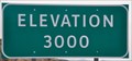 view gallery view galleryS17.2 km | Interstate 17 Southbound ~ Elevation 3000 Feet in Elevation Signs This Elevation Sign is in the mountains southwest of Cordes Lakes, Arizona on Interstate 17. posted by: brwhiz location: Arizona date approved: 09/07/2012 last visited: 08/12/2019 |
 view gallery view gallery SE17.9 km SE17.9 km
| Perry Mesa, Hohokam Nation, Arizona (045) in New World Ancient Evidence Located on the north east area of Perry Mesa. posted by: CoinsAndPins location: Arizona date approved: 12/08/2009 last visited: 01/28/2018 |
 view gallery view gallerySE18.2 km | Perry Mesa, Hohokam Nation, Arizona (042) in New World Ancient Evidence Located on the north east area of Perry Mesa. posted by: CoinsAndPins location: Arizona date approved: 12/08/2009 last visited: 06/15/2016 |
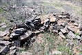 view gallery view gallerySE18.2 km | Perry Mesa, Hohokam Nation, Arizona (044) in New World Ancient Evidence Located on the north east area of Perry Mesa not far from the Rosalie Mine. posted by: CoinsAndPins location: Arizona date approved: 12/08/2009 last visited: 11/19/2020 |
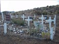
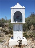 view gallery view galleryNW23.3 km |  Wayside shrine - Christakos, Mayer, AZ Wayside shrine - Christakos, Mayer, AZ
in Wayside shrines This shrine is located on the West side of Highway 69, 0.3 miles north of mile marker 277, near Mayer, Arizona. posted by: Poehunters location: Arizona date approved: 08/09/2013 last visited: 04/01/2017 |
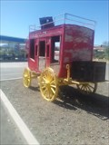 view gallery view galleryNW24.6 km |  Restored Stagecoach - Humboldt AZ Restored Stagecoach - Humboldt AZ
in Carriages and Coaches on Permanent Display Here is a restored stagecoach, standing proudly on display behind the Chevron station - 2735 AZ-69, Humboldt, AZ posted by: Where's George location: Arizona date approved: 11/07/2017 last visited: never |
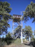 view gallery view gallery W25.6 km W25.6 km
|  Towers Mountain Lookout Towers Mountain Lookout
in Look-Out Towers Towers Mountain Lookout posted by: The Yellow Squid location: Arizona date approved: 10/08/2007 last visited: never |
 view gallery view galleryNW25.6 km | Humboldt Cemetery - Humboldt, Arizona, USA in Worldwide Cemeteries This cemetery is participating in the Arizona Centennial Celebrations. posted by: Tsegi Mike and Desert Viking location: Arizona date approved: 09/09/2011 last visited: 03/15/2014 |
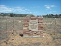 view gallery view galleryNW25.6 km |  Arizona Centennial Memorial - Humbolt Cemetery - Arizona Arizona Centennial Memorial - Humbolt Cemetery - Arizona
in Community Commemoration Inside a local cemetery, a large monument commemorates the upcoming Arizona Centennial Celebration. posted by: Tsegi Mike and Desert Viking location: Arizona date approved: 09/09/2011 last visited: 03/15/2014 |
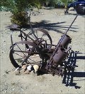 view gallery view galleryS27.2 km |  Antique Horse-Drawn Seeder - Black Canyon City AZ Antique Horse-Drawn Seeder - Black Canyon City AZ
in Old Agricultural Equipment This interesting piece of equipment is one of two pieces that reside on display outside Nora Jean's Koffee Kitchen - 18850 School House Rd posted by: Where's George location: Arizona date approved: 05/31/2019 last visited: 06/05/2023 |
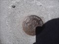
 view gallery view galleryS27.2 km |  ET0177 - Black Canyon City AZ ET0177 - Black Canyon City AZ
in U.S. Benchmarks Follow Old Black Canyon Highway to the north side of town, to the bridge that crosses the Agua Fria River. The benchmark, one of two on this same bridge, is located on the northwest corner of the bridge. posted by: Where's George location: Arizona date approved: 05/10/2013 last visited: never |
 view gallery view galleryS27.4 km | ET0176 - Black Canyon City AZ in U.S. Benchmarks Follow Old Black Canyon Highway to the north side of town, to the bridge that crosses the Agua Fria River. The benchmark, one of two on this same bridge, is located on the southwest corner of the bridge. posted by: Where's George location: Arizona date approved: 05/10/2013 last visited: never |
 view gallery view galleryS27.5 km |  TIC Black Canyon City Chamber of Commerce and Visitor Center - Black Canyon City AZ TIC Black Canyon City Chamber of Commerce and Visitor Center - Black Canyon City AZ
in Tourist Information Centers - Visitor Centers "Black Canyon City is an unincorporated community. A large percentage of the residents are retired. Many others work in Phoenix, or surrounding areas but choose to live outside of the city congestion and pollution." posted by: Where's George location: Arizona date approved: 08/25/2014 last visited: 06/22/2023 |
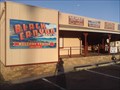
 view gallery view galleryS27.5 km |  Beni's Pizza - Black Canyon City AZ Beni's Pizza - Black Canyon City AZ
in Independent Pizza Restaurants Beni's Pizza is a wonderful indy pizza place in the small town of Black Canyon City. Located in the same building as the previous Byler's Amish Restaurant, Beni's follows the tradition of great food from this location. posted by: Where's George location: Arizona date approved: 08/25/2014 last visited: 06/22/2023 |
|