 view gallery view gallery SE73.7 km SE73.7 km
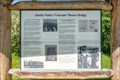
|   Alaska Native Veterans' Honor Bridge - Nenana, AK Alaska Native Veterans' Honor Bridge - Nenana, AK
in Alaska Historic Markers This marker discusses the Alaska Natives who have served in the US Armed Forces, and the bridge to the north that was dedicated in their honour. The marker is located in a small park at the south end of Nenana, Alaska. posted by:  The A-Team The A-Team location: Alaska date approved: 10/19/2023 last visited: never |
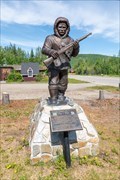 view gallery view gallerySE73.7 km |  Alaska Territorial Guard - Nenana, Alaska Alaska Territorial Guard - Nenana, Alaska
in Figurative Public Sculpture This statue commemorates the Alaska Territorial Guard, which helped with reconnaissance and defense in Alaska during World War II. It's located in a small park at the south end of Nenana, Alaska. posted by: The A-Team location: Alaska date approved: 10/19/2023 last visited: never |
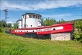 view gallery view gallerySE73.7 km |  Taku Chief - Nenana, Alaska Taku Chief - Nenana, Alaska
in Landlocked Boats The Taku Chief is a former tug that is now on display in a park at the south end of Nenana, Alaska. posted by: The A-Team location: Alaska date approved: 10/14/2023 last visited: never |
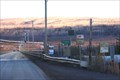
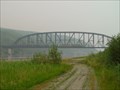 view gallery view gallerySE74 km |  Mears Memorial Bridge -- Nenana, AK Mears Memorial Bridge -- Nenana, AK
in Truss Bridges Mears Memorial Bridge crosses the Tanana River at Nenana, AK. posted by: wilsonjw location: Alaska date approved: 10/11/2017 last visited: 12/31/2022 |
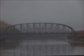 view gallery view gallerySE74 km |  Mears Memorial Bridge -- Nenana, AK USA Mears Memorial Bridge -- Nenana, AK USA
in Wikipedia Entries The Mears Memorial Bridge was inaugurated in 1923 by Pres. Warren G Harding who drove a golden spike here, signifying the completion of the the Alaska Railroad. posted by: Benchmark Blasterz location: Alaska date approved: 12/01/2022 last visited: 01/30/2023 |
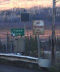
 view gallery view gallery NE99.5 km NE99.5 km
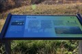
|  Fire Sparks New Life -- Dalton Hwy MP 20.7, Yukon-Koyokuk Borough, AK USA Fire Sparks New Life -- Dalton Hwy MP 20.7, Yukon-Koyokuk Borough, AK USA
in Flora and Fauna Information Signs One of two flora and fauna information science at this new pullout at milepost 20.7 on the Dalton Highway posted by: Benchmark Blasterz location: Alaska date approved: 11/30/2022 last visited: 12/01/2022 |
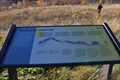 view gallery view galleryNE99.5 km | Reading the Land -- Dalton Hwy MP 20.7, Yukon-Koyokuk Borough, AK USA in Flora and Fauna Information Signs Second of two flora and fauna information science at this new pullout at milepost 20.7 on the Dalton Highway posted by: Benchmark Blasterz location: Alaska date approved: 11/30/2022 last visited: 12/01/2022 |
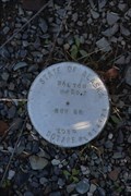 view gallery view galleryNE99.5 km |  AK DOT/PF BM Dalton MP 20.7 -- Dalton Highway, Yukon-Koyokuk Borough, AK USA AK DOT/PF BM Dalton MP 20.7 -- Dalton Highway, Yukon-Koyokuk Borough, AK USA
in U.S. Benchmarks Benchmark placed by the state of Alaska Department of Transportation and Public Facilities, at the pullout/rest area at milepost 20.7 of the Dalton Highway. posted by: Benchmark Blasterz location: Alaska date approved: 11/30/2022 last visited: 12/01/2022 |
 view gallery view gallery N108.5 km N108.5 km
|  E. L. Patton Yukon River Bridge -- Dalton Hwy, Yukon-Koyokuk Borough, AK USA E. L. Patton Yukon River Bridge -- Dalton Hwy, Yukon-Koyokuk Borough, AK USA
in Plank Roads This bridge carrying the Dalton Highway over the Yukon River is made of planks, which are more durable than asphalt or concrete in this extreme Arctic environment posted by: Benchmark Blasterz location: Alaska date approved: 11/30/2022 last visited: 12/01/2022 |
 view gallery view galleryN108.5 km |  E. L. Patton Yukon River Bridge -- Dalton Hwy, Yukon-Koyokuk Borough, AK USA E. L. Patton Yukon River Bridge -- Dalton Hwy, Yukon-Koyokuk Borough, AK USA
in Solar Power A small solar array panel on the EL Patton bridge over the Yukon River powers lights on the bridge posted by: Benchmark Blasterz location: Alaska date approved: 11/30/2022 last visited: 12/01/2022 |
 view gallery view galleryN109.1 km |  Yukon River Camp Truck Stop -- Yukon-Koyukuk Borough, AK USA Yukon River Camp Truck Stop -- Yukon-Koyukuk Borough, AK USA
in Truck Stops There are a few places along the Dalton Highway to stop for food or fuel. The Yukon River Camp truck stop is the second of three places on this Arctic Highway to gas up posted by: Benchmark Blasterz location: Alaska date approved: 11/30/2022 last visited: 03/01/2023 |
 view gallery view gallerySE136.2 km |  Counting Display "Bottles Saved" -- 49th State Brewing Company, Healy, Denali Borough, AK USA Counting Display "Bottles Saved" -- 49th State Brewing Company, Healy, Denali Borough, AK USA
in Counting and Measuring Displays The Counting Display "Bottles Saved" at 49th State Brewing Company, Healy, Denali Borough, AK USA posted by: Benchmark Blasterz location: Alaska date approved: 04/10/2023 last visited: 04/13/2023 |
 view gallery view gallery S142.4 km S142.4 km
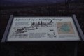
| Ice Age Hunters - Denali National Park in Alaska Historic Markers Ice age hunters flowed the Caribou trails through Denali. Located at a rest stop along the Park Road in the Denali Nation Park. See parks web site for access information. posted by:  Lat34North Lat34North location: Alaska date approved: 01/23/2014 last visited: 07/11/2016 |
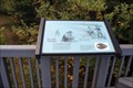
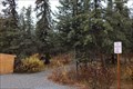
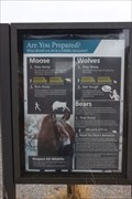 view gallery view galleryS143.1 km | Are You Prepared? — Savage River Picnic Area, Denali Park Road MP 13, Denali National Park, AK USA in Flora and Fauna Information Signs One of three flora and fauna information signs at the Savage River picnic area in the loop trail head in Denali National Park, this one gives excellent advice about dealing with moose, bear, and wolves - which are commonly seen in the park posted by: Benchmark Blasterz location: Alaska date approved: 12/01/2022 last visited: 01/30/2023 |
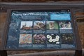 view gallery view galleryS143.1 km | Crossing Paths with the Locals -- Savage River Picnic Area, Denali Park Road MP 13, Denali National Park, AK USA in Flora and Fauna Information Signs Second of three flora and fauna information signs at the Savage River picnic area at the Savage River Loop trailhead in Denali National Park, this sign identifies local plants and animals commonly seen in this area posted by: Benchmark Blasterz location: Alaska date approved: 12/01/2022 last visited: 01/30/2023 |
 view gallery view galleryS143.1 km | Life on a Braided River-- Savage River Picnic Area, Denali Park Road MP 13, Denali National Park, AK USA in Flora and Fauna Information Signs Third of three flora and fauna information signs at the Savage River picnic area in the loop trail head in Denali National Park posted by: Benchmark Blasterz location: Alaska date approved: 12/01/2022 last visited: 01/30/2023 |
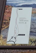 view gallery view galleryS143.1 km |  YAH -- Savage River Loop Trailhead, Denali Park Road MP 13, Denali National Park, AK USA YAH -- Savage River Loop Trailhead, Denali Park Road MP 13, Denali National Park, AK USA
in 'You Are Here' Maps A You are Here map at the Savage River Loop Trailhead at Denali National Park posted by: Benchmark Blasterz location: Alaska date approved: 12/01/2022 last visited: 01/30/2023 |
 view gallery view galleryS145.6 km |  Savage Cabin Interpretive Loop Trail -- Park Road, Denali National Park, AK USA Savage Cabin Interpretive Loop Trail -- Park Road, Denali National Park, AK USA
in Hiking and walking trailheads The Savage Cabin Interpretive Loop Trailhead, along the Park Road, Denali National Park, AK USA posted by: Benchmark Blasterz location: Alaska date approved: 12/02/2022 last visited: 01/30/2023 |
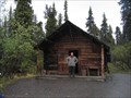 view gallery view galleryS145.8 km |  Upper Savage River Cabin No. 30 - Denali National Park Upper Savage River Cabin No. 30 - Denali National Park
in U.S. National Register of Historic Places A stop on the Natural History Tour in Denali National Park. posted by: heringermr location: Alaska date approved: 07/19/2008 last visited: 06/16/2023 |
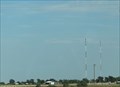 view gallery view galleryS146 km |  K204GP-FM 88.7 (KRBG) & K223AU-FM 92.5 (KXLV) -- Dumas TX USA K204GP-FM 88.7 (KRBG) & K223AU-FM 92.5 (KXLV) -- Dumas TX USA
in Radio and Television Transmitter Towers The small town of Dumas, TX (home of the Ding-Dong Daddy <-- NOT MAKING THAT UP), has two low-power FM translators bringing the distant stations from Amarillo to this part of West Texas posted by: Benchmark Blasterz location: Texas date approved: 01/30/2023 last visited: 02/01/2023 |
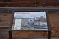
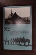 view gallery view galleryS146 km | Savage Camp -- Denali Park Road, Denali National Park, AK USA in Alaska Historic Markers This historical marker is located at the trailhead shed waiting area for the Savage camp bus stop along the Park Road in Denali National Park posted by: Benchmark Blasterz location: Alaska date approved: 12/16/2022 last visited: 01/30/2023 |
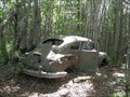 view gallery view galleryS146.5 km |  The Getaway Car, Houston, Alaska The Getaway Car, Houston, Alaska
in Abandoned Dead Vehicles We were lured to this wooded area by a geocache and found this most intriguing car there. posted by: Queens Blessing location: Alaska date approved: 07/28/2010 last visited: 09/15/2012 |
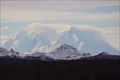 view gallery view gallerySE147.7 km |  Denali Peaks Look-out-- Park Road MP 10.6, Denali National Park, AK USA Denali Peaks Look-out-- Park Road MP 10.6, Denali National Park, AK USA
in Scenic Roadside Look-Outs This roadside look-out along the Denali Park Road 10.6 miles from the Visitor Center gives an amazing view of the Denali peaks, for which this park is named posted by: Benchmark Blasterz location: Alaska date approved: 12/13/2022 last visited: 01/30/2023 |
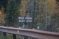 view gallery view gallerySE151.3 km |  2030 feet -- Bridge over Rock Creek, Denali Park Road, Denali National Park, AK USA 2030 feet -- Bridge over Rock Creek, Denali Park Road, Denali National Park, AK USA
in Elevation Signs Two elevation signs, one on each side of Rock Creek let you know you are 2300 feet above sea level posted by: Benchmark Blasterz location: Alaska date approved: 12/01/2022 last visited: 01/30/2023 |
 view gallery view galleryN158.2 km | Lifeblood of a Wildlife Refuge -- Finger Mountain, Yukon-Koyukuk Borough, AK USA in Flora and Fauna Information Signs Second of three flora and fauna signs at the Finger Mountain landmark along the Dalton Highway. posted by: Benchmark Blasterz location: Alaska date approved: 11/30/2022 last visited: 12/01/2022 |
|