 view gallery view gallery E2.7 km E2.7 km
|   Chesapeake Beach Veterans Memorial Chesapeake Beach Veterans Memorial
in Non-Specific Veteran Memorials This is a Memorial to those that gave 'ALL'. posted by:  Mother Wolf Mother Wolf location: Maryland date approved: 11/21/2008 last visited: 06/04/2020 |
 view gallery view gallery SE2.7 km SE2.7 km
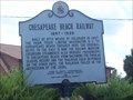
|  CHESAPEAKE BEACH RAILWAY CHESAPEAKE BEACH RAILWAY
in Maryland Historical Markers The historical marker sits on a small median on the edge of the parking lot to the Chesapeake Beach Railway Museum. There is plenty of room to park in the lots nearby. posted by: redlights location: Maryland date approved: 08/14/2008 last visited: never |
 view gallery view gallery SW4.3 km SW4.3 km
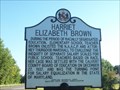
| HARRIET ELIZABETH BROWN in Maryland Historical Markers This historical marker is along Route 2 at the junction of Pushaw Station Road. Parking is available at the Parks & Recreation facility behind the sign itself. posted by: redlights location: Maryland date approved: 08/14/2008 last visited: 01/02/2020 |
 view gallery view gallerySW5 km |  Subway - Solomons Island Rd. - Sunderland, MD Subway - Solomons Island Rd. - Sunderland, MD
in Subway Restaurants A Subway in Sunderland, Maryland. posted by: bluesnote location: Maryland date approved: 12/20/2021 last visited: never |
 view gallery view gallerySW5.8 km | THE FIRST ALL SAINTS CHURCH in Maryland Historical Markers This historical marker is on the same grounds, just behind, of the All Saints Episcopal Church in Sunderland, MD. posted by: redlights location: Maryland date approved: 08/14/2008 last visited: 12/28/2019 |
 view gallery view gallerySW6 km | ALL SAINTS EPISCOPAL CHURCH in Maryland Historical Markers This marker in on the grounds of the All Saints Episcopal Church in Sunderland, MD, right where Routes 2 and 4 connect in Calvert County. posted by: redlights location: Maryland date approved: 08/14/2008 last visited: 12/28/2019 |
 view gallery view gallery W6.9 km W6.9 km
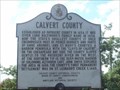
| CALVERT COUNTY (no. 1) in Maryland Historical Markers This historical marker is on the property of the Calvert County Welcome Center in Owings, MD, just off of Route 4. posted by: redlights location: Maryland date approved: 08/23/2008 last visited: 06/28/2012 |
 view gallery view galleryW6.9 km |  'You Are Here' Maps-A County in Ruin Star - Owings, MD 'You Are Here' Maps-A County in Ruin Star - Owings, MD
in 'You Are Here' Maps The 'You Are Here' Map shows that you are on the grounds of the Fairview Public Library and Visitor Center, Southern Maryland Blvd (SR 4),Owings, MD United States 20736 posted by:  Don.Morfe Don.Morfe location: Maryland date approved: 09/13/2023 last visited: 09/13/2023 |
 view gallery view galleryW6.9 km |  A County in Ruin - Owings, MD A County in Ruin - Owings, MD
in Battlefields The marker is located on the grounds of the Fairview Public Library and Visitor Center, Southern Maryland Blvd (SR 4),Owings, MD United States 20736 posted by: Don.Morfe location: Maryland date approved: 09/15/2023 last visited: 09/15/2023 |
 view gallery view galleryW6.9 km |  A County in Ruin Star-Spangled Banner National Historic Trail - Owings, MD A County in Ruin Star-Spangled Banner National Historic Trail - Owings, MD
in War of 1812 British raiding parties brought the war to Calvert County in 1814, destroying plantations and towns and carrying away the spoils. posted by: Don.Morfe location: Maryland date approved: 03/11/2020 last visited: 11/02/2021 |
 view gallery view galleryW6.9 km |  A County in Ruin Star-Spangled Banner National Historic Trail - Owings, MD A County in Ruin Star-Spangled Banner National Historic Trail - Owings, MD
in Signs of History British raiding parties brought the war to Calvert County in 1814, destroying plantations and towns and carrying away the spoils. posted by: Don.Morfe location: Maryland date approved: 08/30/2022 last visited: 08/30/2022 |
 view gallery view gallery N8.2 km N8.2 km
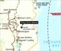
| Outnumbered Star-Spangled Banner National Historic Trail - Tracys Landing MD in War of 1812 When 250-300 British troops crossed from Tilghman Island to Town Point on October 27, 1814, they easily overcame five local militiamen manning a nine-pound cannon. They burned three buildings, and a windmill. posted by: Don.Morfe location: Maryland date approved: 03/23/2020 last visited: 11/02/2021 |
 view gallery view galleryN8.2 km | Outnumbered Star-Spangled Banner National Historic Trail - Tracys Landing MD in Signs of History When 250-300 British troops crossed from Tilghman Island to Town Point on October 27, 1814, they easily overcame five local militiamen manning a nine-pound cannon. They burned three buildings, and a windmill. posted by: Don.Morfe location: Maryland date approved: 09/05/2022 last visited: 09/05/2022 |
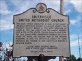 view gallery view galleryW8.9 km | SMITHVILLE UNITED METHODIST CHURCH in Maryland Historical Markers This is another historical marker located within Calvert County, Maryland. It is located just west of route 4 in Dunkirk, MD in front of the church. If you are visiting on Sundays please be respectful of the worshippers there. posted by: redlights location: Maryland date approved: 08/23/2008 last visited: 08/07/2013 |
 view gallery view galleryN10.1 km |  St. James' Parish (Lothian, Maryland) St. James' Parish (Lothian, Maryland)
in Wikipedia Entries St. James' Episcopal Parish is a historic church located at 5757 Solomons Island Road in the hamlet of Tracys Landing, Anne Arundel County, Maryland. The current church was completed in 1765, and continues to serve the congregation today. posted by: Don.Morfe location: Maryland date approved: 05/19/2022 last visited: 06/04/2020 |
 view gallery view galleryN10.1 km | Lothian, Maryland in Wikipedia Entries The GPS coordinates are for St. James Church in Lothian MD. Lothian is an unincorporated community in Anne Arundel County, Maryland, United States. As of the 2010 Census, the population was 6,643 people. posted by: Don.Morfe location: Maryland date approved: 05/30/2024 last visited: 06/04/2020 |
 view gallery view galleryN10.1 km |  St. James' Parish Episcopal Church Book Exchange - Lothian MD St. James' Parish Episcopal Church Book Exchange - Lothian MD
in Free Community Book Exchanges The free book exchange is located at the end of the parking lot of St. James Parish Episcopal Church. The sign states Take one (1), Leave one (1). posted by: Don.Morfe location: Maryland date approved: 05/19/2022 last visited: 05/19/2022 |
 view gallery view galleryN10.1 km |  St. James Church - Lothian MD St. James Church - Lothian MD
in U.S. National Register of Historic Places St. James' Parish Episcopal Church is built on the site of two previous churches (1689 and pre-1692). The cemetery contains some 17th-century graves and includes one of the oldest known tombstones (1665) in the state. posted by: Don.Morfe location: Maryland date approved: 05/20/2022 last visited: 06/04/2020 |
 view gallery view galleryN10.1 km |  St. James Church - Lothian MD St. James Church - Lothian MD
in This Old Church St. James' Episcopal Parish is a historic church located at 5757 Solomons Island Road in the hamlet of Tracys Landing, Anne Arundel County, Maryland. The current church was completed in 1765, and continues to serve the congregation today. posted by: Don.Morfe location: Maryland date approved: 05/20/2022 last visited: 06/04/2020 |
 view gallery view galleryN10.1 km |  St. James' Parish Episcopal Church - Lothian MD St. James' Parish Episcopal Church - Lothian MD
in Anglican and Episcopal Churches St. James' Episcopal Parish is a historic church located at 5757 Solomons Island Road in the hamlet of Tracys Landing, Anne Arundel County, Maryland. The current church was completed in 1765, and continues to serve the congregation today. posted by: Don.Morfe location: Maryland date approved: 05/19/2022 last visited: 06/04/2020 |
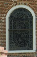 view gallery view galleryN10.1 km |  Stained Glass Windows at St, James Parish Episcopal Church - Lothian MD Stained Glass Windows at St, James Parish Episcopal Church - Lothian MD
in Stained Glass Windows There are several stained glass windows on the side of St. James Parish Episcopal Church located in Lothian MD. The current church was completed in 1765, and continues to serve the congregation today. posted by: Don.Morfe location: Maryland date approved: 05/19/2022 last visited: 05/19/2022 |
 view gallery view galleryN10.1 km |  St. James' Parish Episcopal Churchyard Cemetery - Lothian MD St. James' Parish Episcopal Churchyard Cemetery - Lothian MD
in Churchyard Cemeteries The church was listed on the National Register of Historic Places in 1972. The property includes a cemetery which includes what is believed to be the oldest dated grave in the state (1655). posted by: Don.Morfe location: Maryland date approved: 05/19/2022 last visited: 06/04/2020 |
 view gallery view galleryN10.1 km |  St. James' Parish Episcopal Churchyard Cemetery - Lothian MD St. James' Parish Episcopal Churchyard Cemetery - Lothian MD
in Worldwide Cemeteries The church was listed on the National Register of Historic Places in 1972. The property includes a cemetery which includes what is believed to be the oldest dated grave in the state (1655). posted by: Don.Morfe location: Maryland date approved: 05/19/2022 last visited: 06/04/2020 |
 view gallery view gallery NW10.6 km NW10.6 km
| Saint James' Church in Maryland Historical Markers Saint James' Church
Old Herring Creek Parish posted by: pseudoprime location: Maryland date approved: 04/06/2009 last visited: 05/19/2022 |
 view gallery view gallerySW10.6 km |  7/11 - Soloman Islands Rd. - Huntingtown, MD 7/11 - Soloman Islands Rd. - Huntingtown, MD
in 7-Eleven Stores A 7/11 in Huntingtown, Maryland. posted by: bluesnote location: Maryland date approved: 11/21/2018 last visited: 11/21/2018 |
|