 view gallery view gallery N24.1 km N24.1 km
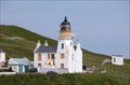
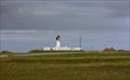
|   Holburn Head Lighthouse Holburn Head Lighthouse
in Coastal Lighthouses Unusual 19th century lighthouse. posted by:  twirliegirly twirliegirly location: United Kingdom date approved: 09/05/2013 last visited: 08/05/2019 |
 view gallery view gallery E24.5 km E24.5 km
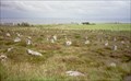
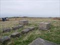
|  Hill o'Many Stanes, Caithness, Scotland Hill o'Many Stanes, Caithness, Scotland
in Megalithic Monuments The Hill O Many Stanes is a south-facing hillside in Mid Clyth, about 14 kilometres (9 miles) south of Wick in Caithness. posted by: nessie3d & Ynka location: Northern Scotland, United Kingdom date approved: 05/28/2011 last visited: 10/13/2015 |
 view gallery view gallery NW31.7 km NW31.7 km
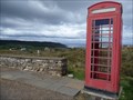
|  Lednagullin, north coast of Scotland Lednagullin, north coast of Scotland
in Red Telephone Boxes An red telephone box in a very scenic Scottish location. posted by: The Blorenges location: Northern Scotland, United Kingdom date approved: 08/07/2010 last visited: never |
 view gallery view gallery NE32.7 km NE32.7 km
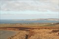
|  Dunnet head, Thurso, Scotland,UK Dunnet head, Thurso, Scotland,UK
in World War II Sites Dunnet Head Radar Station was a World War II radar station located on the peninsula of Dunnet Head, Caithness, on the extreme north coast of Scotland. The site lies adjacent to Easter Head, the most northerly point of mainland Great Britain posted by:  MoreOutdoor MoreOutdoor location: Northern Scotland, United Kingdom date approved: 05/25/2022 last visited: 05/26/2022 |
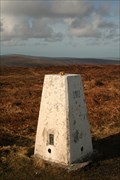
 view gallery view galleryNE32.7 km |  Dunnet Head,Thurso, Scotland,UK Dunnet Head,Thurso, Scotland,UK
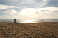
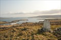
in U.K. and Ireland Trigpoints Dunnet Head trig point, Britain's most northerly Trig point. posted by: MoreOutdoor location: Northern Scotland, United Kingdom date approved: 05/25/2022 last visited: 05/25/2022 |
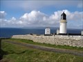
 view gallery view galleryNE32.8 km | Dunnet Head Lighthouse, Caithness, Scotland in Coastal Lighthouses A 20 m tall lighthouse on a 105 m cliff top on the northern coastal line of Scotland. posted by: nessie3d & Ynka location: Northern Scotland, United Kingdom date approved: 05/28/2011 last visited: 04/24/2022 |
 view gallery view galleryNE32.8 km |  Dunnet Head Lighthouse - Caithness, Scotland Dunnet Head Lighthouse - Caithness, Scotland
in Satellite Imagery Oddities Dunnet Head Lighthouse is located at the most northerly point of the Scottish mainland. posted by: Mike_bjm location: Northern Scotland, United Kingdom date approved: 11/29/2021 last visited: 05/17/2022 |
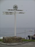 view gallery view galleryNE41 km |  John o'Groats signpost - Scotland John o'Groats signpost - Scotland
in Direction and Distance Arrows The famous road sign of John o'Groats - Scotland posted by: cache-amount location: Northern Scotland, United Kingdom date approved: 10/23/2013 last visited: 04/22/2022 |
 view gallery view galleryNE41 km | John O Groats sign (Old), Harbour wall, John O Groats, Scotland, UK in Direction and Distance Arrows The original first and last post at John O Groats was perhaps not so well "photogenic". Set on the small harbour wall was perhaps not that appealing to the present-day photographer posted by: MoreOutdoor location: Northern Scotland, United Kingdom date approved: 05/26/2022 last visited: 05/26/2022 |
 view gallery view galleryNE41.7 km |  MFV George Robb- Duncansby Stacks, Caithness, Scotland, UK MFV George Robb- Duncansby Stacks, Caithness, Scotland, UK
in Maritime Monuments and Memorials A fishing trawler, formally a minesweeper "George Robb", runs aground, during a storm with the tragic loss of life.
The vessel lay on the rocks for many years, but with time broke up and sank without a trace. posted by: MoreOutdoor location: Northern Scotland, United Kingdom date approved: 06/11/2022 last visited: 06/12/2022 |
 view gallery view gallery S49.4 km S49.4 km
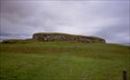
|  Carn Liath, Golspie, Sutherland, Scotland Carn Liath, Golspie, Sutherland, Scotland
in Remains of Settlements A 'broch' which lies on a mound and overlooks the Sutherland coast. Close to the A9 posted by: nessie3d & Ynka location: Northern Scotland, United Kingdom date approved: 06/28/2011 last visited: 05/22/2022 |
 view gallery view gallery SW50.7 km SW50.7 km
|  Dunrobin Castle, Golspie, Sutherland, Scotland, UK Dunrobin Castle, Golspie, Sutherland, Scotland, UK
in Castles Originally only a fortified, square keep, extensions in the following centuries made it the complex you're witnessing. posted by: nessie3d & Ynka location: Northern Scotland, United Kingdom date approved: 06/04/2011 last visited: 04/05/2012 |
 view gallery view galleryN63.2 km | Hill of Midland in U.K. and Ireland Trigpoints Pillar at the top of the Hill of Midland in Orphir, Orkney posted by: jleith location: United Kingdom date approved: 04/03/2007 last visited: 12/15/2007 |
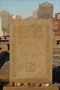 view gallery view galleryN63.7 km |  George Mackay Brown George Mackay Brown
in Dead Poets' Society Memorials The grave of George Mackay Brown, Warbeth Cemetry, Near Stromness, Orkney. posted by: jleith location: Northern Scotland, United Kingdom date approved: 04/01/2007 last visited: 08/05/2019 |
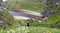
 view gallery view galleryN63.9 km |  Stromness from Scorradale Stromness from Scorradale
in Cityscapes Ths view shows Hoy, Graemsay, Hoy Sound and Stromness posted by: jleith location: Northern Scotland, United Kingdom date approved: 04/03/2007 last visited: never |
 view gallery view galleryN65.3 km | Brinkies Brae, Orkney in U.K. and Ireland Trigpoints Brinkies Brae, Overlooking Stromness, Orkney posted by: jleith location: United Kingdom date approved: 03/30/2007 last visited: 08/05/2019 |
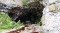 view gallery view gallery W67.6 km W67.6 km
| ") Smoo Cave, Durness in Sutherland, Scotland, UK Smoo Cave, Durness in Sutherland, Scotland, UK
in Cave Entrances (Natural) The largest sea cave in the UK posted by: g300td location: United Kingdom date approved: 09/10/2014 last visited: 07/05/2017 |
 view gallery view galleryW67.6 km |  The Stairway to "Smoo Cave", Durness in Sutherland, Scotland, UK The Stairway to "Smoo Cave", Durness in Sutherland, Scotland, UK
in Outdoor Stairways The stairway to the largest sea cave in the UK posted by: g300td location: Northern Scotland, United Kingdom date approved: 09/10/2014 last visited: 06/30/2017 |
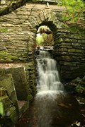 view gallery view galleryN68.7 km |  Happy Valley Happy Valley
in Man-made Waterfalls The waterfall near the entrance to Happy Valley, Germiston, Stenness. posted by: jleith location: United Kingdom date approved: 04/02/2007 last visited: never |
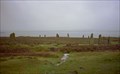
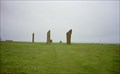 view gallery view galleryN69.8 km | The Standing Stones o' Stenness, Stenness, Scotland in Megalithic Monuments Even in daylight the place has something uncanny about it. The Standing Stones o' Stenness, mouldering, scarred and grey with age, rising as they do from an unbroken bed of heather always have a weird mysterious appearance. posted by: nessie3d & Ynka location: Northern Scotland, United Kingdom date approved: 05/28/2011 last visited: 07/11/2021 |
 view gallery view galleryN69.8 km |  Heart of Neolithic Orkney - Scotland, UK Heart of Neolithic Orkney - Scotland, UK
in World Heritage Sites This World Heritage Site comprises Skara Brae, Maes Howe, the Ring of Brodgar and the Standing Stones of Stenness. posted by: netdust location: Northern Scotland, United Kingdom date approved: 09/29/2014 last visited: 08/05/2019 |
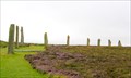
 view gallery view galleryN70.2 km | The Ring o' Brodgar, Stenness, Scotland in Megalithic Monuments The Ring of Brodgar is the finest known truly circular late Neolithic or early Bronze Age stone ring and a later expression of the spirit which gave rise to Maeshowe, Stenness and Skara Brae. posted by: nessie3d & Ynka location: Northern Scotland, United Kingdom date approved: 05/28/2011 last visited: 08/05/2019 |
 view gallery view galleryN72.3 km |  Heddle Quarry Heddle Quarry
in Active Quarries Heddle Quarry, near Finstown, Orkney posted by: jleith location: Northern Scotland, United Kingdom date approved: 04/04/2007 last visited: never |
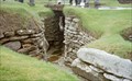 view gallery view galleryN72.9 km | Skara Brae, Orkney, Scotland in Remains of Settlements These are the remains of a settlement which florished between 3200BC and 2200BC. Meaning it is older than Stonehenge or the Pyramids ... posted by: nessie3d & Ynka location: Northern Scotland, United Kingdom date approved: 06/28/2011 last visited: 04/11/2023 |
 view gallery view galleryNE73.2 km | Wideford Hill, Orkney in U.K. and Ireland Trigpoints The OS trig point at the top of Wideford Hill near Kirkwall, Orkney posted by: jleith location: United Kingdom date approved: 03/22/2007 last visited: 08/06/2019 |
|