 view gallery view gallery W3.2 km W3.2 km
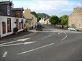
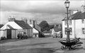
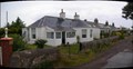
|   Kippford Slipway Pump, Dumfries and Galloway Kippford Slipway Pump, Dumfries and Galloway
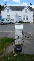
in Hand Operated Water Pumps Beside the slipway at Kippford is a wooden boxed hand pump in good condition with handle and new paint. posted by:  flipflopnick flipflopnick location: Southern Scotland, United Kingdom date approved: 11/13/2010 last visited: never |
 view gallery view gallery SW4.5 km SW4.5 km
|  Elephant Rock Hestan Island Scotland UK Elephant Rock Hestan Island Scotland UK
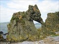
in Simulacra Elephant Rock is a sea stack on the north west corner of Hestan Island, in Auchencairn Bay, between Kirkcudbright and Dumfries, Scotland, UK. Looks like an elephant from both sides. posted by: flipflopnick location: Southern Scotland, United Kingdom date approved: 07/12/2006 last visited: 09/08/2006 |
 view gallery view galleryW5.1 km |  Orchardton Castle, Dumfries and Galloway Orchardton Castle, Dumfries and Galloway
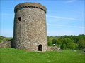
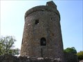
in Castles Orchardton Castle is the only known cylindrical tower in Scotland. There are many similar towers in Ireland, perhaps the mason was of Irish decent. Also known as Orchardton Tower posted by: flipflopnick location: Southern Scotland, United Kingdom date approved: 12/03/2007 last visited: never |
 view gallery view galleryW5.1 km |  Orchardton Tower Orchardton Tower
in Wikipedia Entries Orchardton Tower is the only known cylindrical tower in Scotland. The lands of Orchardton, formally known as Glenshinnoch, were in the possession of the Cairns family from the early 15th century until 1633 when they passed, through a heiress, to the Maxwell family of Drumcolten. posted by: flipflopnick location: Southern Scotland, United Kingdom date approved: 07/11/2008 last visited: never |
 view gallery view galleryW5.1 km |  Orchardton Tower, Dumfries and Galloway Orchardton Tower, Dumfries and Galloway
in English Heritage - Cadw - Historic Scotland Orchardton Tower is free to visit with free parking. A well cared for ruin with neat cut grass. Prolifically sign posted off the A711 road. Superb views from top wall. posted by: flipflopnick location: Southern Scotland, United Kingdom date approved: 07/11/2008 last visited: 05/20/2008 |
 view gallery view gallery NW5.5 km NW5.5 km
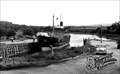
|  Palnackie Harbour, Dumfries and Galloway Palnackie Harbour, Dumfries and Galloway
in Photos Then and Now Palnackie harbour was built with wooden piles and planks around 1850. Only the boat appears to have changed. Looking north east on to the tidal Urr river. posted by: flipflopnick location: Southern Scotland, United Kingdom date approved: 07/11/2008 last visited: never |
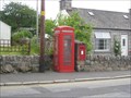
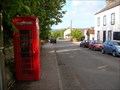 view gallery view galleryNW5.5 km |  Port Road Red Telephone Box, Palnackie, Dumfries and Galloway Port Road Red Telephone Box, Palnackie, Dumfries and Galloway
in Red Telephone Boxes Port Road spurs down to the very small harbour in Palnackie. posted by: flipflopnick location: Southern Scotland, United Kingdom date approved: 07/11/2008 last visited: never |
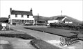
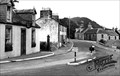 view gallery view galleryNW5.5 km | Glen Isle Inn, Palnackie, Dumfries and Galloway in Photos Then and Now The Glen Isle Inn is on the inside of the main bend, opposite the Old Post Office. The A711 road now bypasses the village. Looking north. posted by: flipflopnick location: Southern Scotland, United Kingdom date approved: 07/11/2008 last visited: never |
 view gallery view galleryNW5.5 km | The Old Post Office, Palnackie, Dumfries and Galloway in Photos Then and Now The former Post Office is now a private house. It is built of local grey granite, and stands on the outside of the main bend in the village. Looking south. posted by: flipflopnick location: Southern Scotland, United Kingdom date approved: 07/11/2008 last visited: never |
 view gallery view galleryNW5.5 km | Palnackie in Wikipedia Entries Palnackie was on the main coastal road. Now the A711 takes the traffic past. Formerly a busy small port that has lost trade to railways and now road transport. See Nearby Waymarks. posted by: flipflopnick location: Southern Scotland, United Kingdom date approved: 07/11/2008 last visited: never |
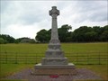 view gallery view gallery NE6.9 km NE6.9 km
|  Caulkerbush War Memorial, Dumfries and Galloway Caulkerbush War Memorial, Dumfries and Galloway
in World War I Memorials and Monuments This memorial to both Great wars stands on the junction outside the village of Caulkerbush, in the parish of Southwick. posted by: flipflopnick location: Southern Scotland, United Kingdom date approved: 06/28/2008 last visited: never |
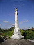 view gallery view galleryW7.1 km | Auchencairn War Memorial, Dumfries and Galloway in World War I Memorials and Monuments Auchencairn village's war memorial is obvious and beside the A711, at bottom of village as road bends to cross burn. Made from white granite. A local person is researching the background to names on the memorial with a dedicated website. posted by: flipflopnick location: Southern Scotland, United Kingdom date approved: 09/12/2006 last visited: never |
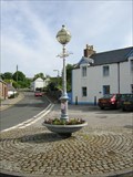 view gallery view galleryW7.2 km |  Auchencairn Jubilee fountain Auchencairn Jubilee fountain
in Converted Fountains The old fountain in Auchencairn has had many uses. Made of cast iron in 1897 by the Coalbrookdale Company, Coalbrookdale, Shropshire. posted by: flipflopnick location: Southern Scotland, United Kingdom date approved: 05/23/2007 last visited: never |
 view gallery view galleryW7.2 km | Auchencairn Square and Fountain, Dumfries and Galloway in Photos Then and Now Looking downhill from Auchencairn Square with the Jubilee fountain in view. Looking north east. posted by: flipflopnick location: Southern Scotland, United Kingdom date approved: 07/02/2008 last visited: never |
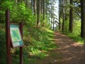
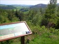 view gallery view galleryNW7.9 km |  Doach Wood Viewpoint, Dumfries and Galloway Doach Wood Viewpoint, Dumfries and Galloway
in Scenic Overlooks Doach plantation is owned by the Forestry Commission and has two walks which both lead to this fine viewpoint, with seating and interpretive board. The view is south over Auchencairn Bay. posted by: flipflopnick location: Southern Scotland, United Kingdom date approved: 05/23/2008 last visited: 07/15/2008 |
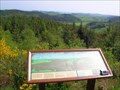 view gallery view galleryNW7.9 km |  Doach Wood Viewpoint Map, Dumfries and Galloway Doach Wood Viewpoint Map, Dumfries and Galloway
in 'You Are Here' Maps Doach Wood viewpoint has an interpretive board detailing the view and a small map lest you forget where you are in the world. posted by: flipflopnick location: Southern Scotland, United Kingdom date approved: 05/23/2008 last visited: 07/15/2008 |
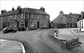
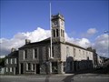 view gallery view galleryNW8.2 km |  Dalbeattie, Dumfries and Galloway - UK Dalbeattie, Dumfries and Galloway - UK
in City and Town Halls Dalbeattie is a town made from local grey granite, and town hall is no exception. Occupying a prominent position on the main crossroads in the town. posted by: flipflopnick location: Southern Scotland, United Kingdom date approved: 12/06/2007 last visited: 07/15/2008 |
 view gallery view galleryNW8.2 km | Doach Wood Parking area map, Dumfries and Galloway in 'You Are Here' Maps Doach Wood is owned by the Forestry Commission and there are two walks laid out. Both shown on this map. Just off the B736. posted by: flipflopnick location: Southern Scotland, United Kingdom date approved: 05/23/2008 last visited: 07/15/2008 |
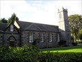 view gallery view galleryNW8.2 km |  St Peter's Church, Dalbeattie, Dumfries and Galloway St Peter's Church, Dalbeattie, Dumfries and Galloway
in This Old Church St Peter's Roman Catholic church is made from pinky granite with red sandstone dressings. Grey granite tower added c.1850. St Peter's is one of the oldest churches in Dalbeattie. posted by: flipflopnick location: Southern Scotland, United Kingdom date approved: 12/12/2007 last visited: 07/15/2008 |
 view gallery view galleryNW10.8 km | Dalbeattie, Dumfries and Galloway. UK in Red Telephone Boxes On the High Street in Dalbeattie, running south toward the A710. Kirkudbright Rd. posted by:  thebigchip thebigchip location: United Kingdom date approved: 07/07/2009 last visited: never |
 view gallery view gallery E10.9 km E10.9 km
| Paul Jones Hotel, Southerness, Dumfriesshire in Photos Then and Now The Paul Jones hotel takes its name from the local boy who made good, and founded the US navy. Looking North West. posted by: flipflopnick location: Southern Scotland, United Kingdom date approved: 07/01/2008 last visited: never |
 view gallery view galleryE10.9 km | Shore Road cottages, Southerness, Dumfries and Galloway in Photos Then and Now Shore Road cottages face south east with a small grass area separating them from the rocky beach. Looking North to north east. posted by: flipflopnick location: Southern Scotland, United Kingdom date approved: 07/01/2008 last visited: never |
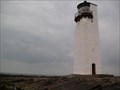 view gallery view galleryE10.9 km |  Southerness Lighthouse, Dumfries and Galloway Southerness Lighthouse, Dumfries and Galloway
in Coastal Lighthouses Southerness Lighthouse stands on the shore a few yards beyond the end of the tarmac, on the promontory that is Southerness Point. posted by: flipflopnick location: Southern Scotland, United Kingdom date approved: 07/21/2008 last visited: never |
 view gallery view galleryNE12.1 km | Criffel in Wikipedia Entries Criffel is a steep sided hill on the coastal strip near New Abbey, Dumfries and Galloway. posted by: flipflopnick location: Southern Scotland, United Kingdom date approved: 07/21/2008 last visited: never |
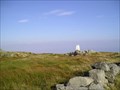 view gallery view galleryNE12.1 km |  Criffel Trig Pillar Dumfries and Galloway UK Criffel Trig Pillar Dumfries and Galloway UK
in U.K. and Ireland Trigpoints Criffel is the highest hill in the area. White classic trig pillar, with nearby Douglas's cairn, huge pile of rocks. Extensive views all around, across the Solway Firth to Cumbria, up the Nith valley and west to Galloway hills. posted by: flipflopnick location: Southern Scotland, United Kingdom date approved: 09/18/2006 last visited: 10/30/2012 |
|