 view gallery view gallery SE32.8 km SE32.8 km
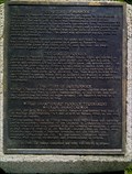
|   Buffalo Rubbing Stone (Near Flaxcombe) Buffalo Rubbing Stone (Near Flaxcombe)
in Saskatchewan Historical Markers Located near the town Flaxcombe on Hwy 7. posted by:  Altima Voyageur Altima Voyageur location: Saskatchewan, Canada date approved: 05/27/2017 last visited: never |
 view gallery view gallery SW36.5 km SW36.5 km
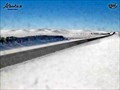
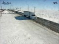
|  Sibbald Highway Web Camera - Sibbald, Alberta Sibbald Highway Web Camera - Sibbald, Alberta
in Web Cameras This Alberta Highways Webcam is mounted on a steel tower along Highway 9 about midway between Oyen and Sibbald. posted by:  T0SHEA T0SHEA location: Alberta, Canada date approved: 03/03/2014 last visited: 08/04/2014 |
 view gallery view gallery S47 km S47 km
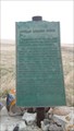
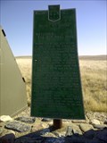
| Battleford/Red Deer Forks Trail in Saskatchewan Historical Markers One of many trails that cross the prairies. The Battleford-Red Deer Forks Trail lies near. posted by: Altima Voyageur location: Saskatchewan, Canada date approved: 05/08/2012 last visited: never |
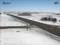 view gallery view gallerySW53.9 km | Oyen Highway Web Camera - Oyen, Alberta in Web Cameras This Alberta Highways Webcam is mounted on a steel tower along Highway 9 about midway between Cereal and Oyen. posted by: T0SHEA location: Alberta, Canada date approved: 03/03/2014 last visited: 07/28/2014 |
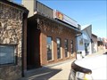
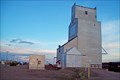
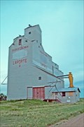 view gallery view gallerySE59.4 km |  Saskatchewan Wheat Pool B - Laporte, Saskatchewan Saskatchewan Wheat Pool B - Laporte, Saskatchewan
in Grain Elevators Along Highway 44, the tiny hamlet of Laporte is 39 short km. east of the Alberta border. posted by: T0SHEA location: Saskatchewan, Canada date approved: 02/07/2013 last visited: 02/22/2014 |
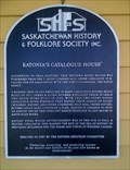 view gallery view gallerySE64.1 km | Eatonia's Catalogue House in Saskatchewan Historical Markers Eatons Catalogue House in Eatonia, near caboose. posted by: Altima Voyageur location: Saskatchewan, Canada date approved: 06/19/2013 last visited: never |
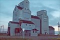 view gallery view gallerySE64.4 km | Saskatchewan Wheat Pool Elevator - Eatonia, Saskatchewan in Grain Elevators Stretching for over 2,000 feet along the north side of Highways 21 & 44, Eatonia presents a somewhat different posture, with an elevator on one side of the road and an airport on the other. posted by: T0SHEA location: Saskatchewan, Canada date approved: 02/07/2013 last visited: 02/22/2014 |
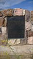
 view gallery view gallery E67.9 km E67.9 km
| Addison Sod House (National Site) in Saskatchewan Historical Markers Both a Provincial and National Site Addison Sod House historic site is a house that was built over a hundred years ago and is still a habitable home. Located north of Kindersley on Hwy 21, then East on Gleneath Road, 10.6 kilometers. posted by: Altima Voyageur location: Saskatchewan, Canada date approved: 09/16/2017 last visited: never |
 view gallery view galleryE67.9 km |  CNHS Addison House CNHS Addison House
in Canadian National Historic Sites National Historic Site Addison Sod House, is a house that was built over a hundred years ago and is still a habitable home. Located north of Kindersley on Hwy 21, then East on Gleneath Road, 10.6 kilometers. posted by: Altima Voyageur location: Saskatchewan, Canada date approved: 09/20/2017 last visited: never |
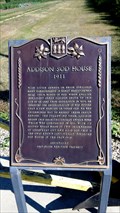 view gallery view galleryE67.9 km | Addison Sod House (Provincial Site) in Saskatchewan Historical Markers Both and provincial and national site the Addison Sod House has lasted over a hundred years. Located north of Kindersley on Hwy 21, then East on Gleneath Road, 10.6 kilometers. posted by: Altima Voyageur location: Saskatchewan, Canada date approved: 09/16/2017 last visited: never |
 view gallery view gallery N75 km N75 km
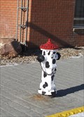
|  Dalmation hydrant - Macklin, Saskatchewan Dalmation hydrant - Macklin, Saskatchewan
in Painted Hydrants This dalmation fire hydrant is located on Main Street in Macklin Saskatchewan. posted by: wildwoodke location: Saskatchewan, Canada date approved: 03/15/2012 last visited: never |
 view gallery view galleryN75.2 km |  Peking Garden Family Restaurant - Macklin, Saskatchewan Peking Garden Family Restaurant - Macklin, Saskatchewan
in Chinese Restaurants This Chinese (and Western) cuisine is one of the few restaurants in the town of Macklin, Saskatchewan. posted by: wildwoodke location: Saskatchewan, Canada date approved: 03/01/2012 last visited: never |
 view gallery view galleryN76.9 km |  Home of the World Bunnock Championship - Macklin, Saskatchewan Home of the World Bunnock Championship - Macklin, Saskatchewan
in Welcome Signs The welcome sign speaks to the sport, that one might relate to horseshoes, that is played in the Town of Macklin, Saskatchewan. posted by: wildwoodke location: Saskatchewan, Canada date approved: 03/01/2012 last visited: never |
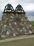
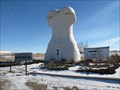 view gallery view galleryN76.9 km |  Giant Bunnock - Macklin, Saskatchewan Giant Bunnock - Macklin, Saskatchewan
in Roadside Attractions This is a giant bunnock, a scaled up version of a bone that is used in a game that was first introduced to Canada by Russian Germans. The world championship is hosted and played in Macklin, Saskatchewan. posted by: wildwoodke location: Saskatchewan, Canada date approved: 02/22/2012 last visited: never |
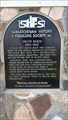
 view gallery view galleryN77.1 km | The History of Bunnock in Saskatchewan Historical Markers Located at junction of Hwy 31 and 14. posted by: Altima Voyageur location: Saskatchewan, Canada date approved: 06/19/2013 last visited: never |
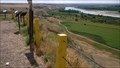
 view gallery view galleryN78.5 km |  Saskatchewan / Alberta Provincial Border crossing #2 Saskatchewan / Alberta Provincial Border crossing #2
in Border Crossings This provincial crossing is between Macklin, Saskatchewan and Provost, Alberta. posted by: StagsRoar location: Saskatchewan, Canada date approved: 06/04/2006 last visited: 06/10/2007 |
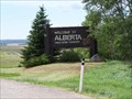
 view gallery view gallery NW80.8 km NW80.8 km
|  The Neutral Hills The Neutral Hills
in Alberta Heritage Markers This cairn is 34 kilometers south of Czar on north side of Buffalo Trail (Hwy 41). Look for Historic signs. posted by: Altima Voyageur location: Alberta, Canada date approved: 09/09/2017 last visited: never |
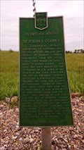
 view gallery view galleryS81.6 km | Checkerboard Hill Lookout in Saskatchewan Historical Markers Located Northwest of Leader. Multiple description boards that describe many area subjects including history. posted by: Altima Voyageur location: Saskatchewan, Canada date approved: 10/19/2017 last visited: never |
 view gallery view gallery W85.1 km W85.1 km
| Youngstown Highway Web Camera - Youngstown, Alberta in Web Cameras This Alberta Highways Webcam is mounted on a steel tower along Highway 9 just west of Youngstown. posted by: T0SHEA location: Alberta, Canada date approved: 03/03/2014 last visited: 07/28/2014 |
 view gallery view galleryS90.9 km | Smith Barn in Saskatchewan Historical Markers This scaled down replica of the actual barn sits near the town of Leader tourist booth located on Hwy 21 and the corner of 5 Avenue East. The actual barn site is located km's North West of Leader. posted by: Altima Voyageur location: Saskatchewan, Canada date approved: 09/16/2017 last visited: never |
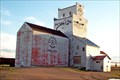
 view gallery view galleryS91.1 km | Saskatchewan Wheat Pool Elevator - Leader, Saskatchewan in Grain Elevators Leader can be found about 160 km. northwest of Swift Current, Saskatchewan, on Highways 32 and 21. posted by: T0SHEA location: Saskatchewan, Canada date approved: 02/01/2013 last visited: 02/28/2014 |
 view gallery view gallerySE98 km | Paterson Elevator - Prelate Saskatchewan in Grain Elevators Where on earth is Prelate? Well, it's around 9 km. west of Sceptre, which is 19 km west of Portreeve, which is 47 km. northwest of Cabri, which is another 63 km. or so up Highway 32 from Speedy Crick, Saskatchewan. posted by: T0SHEA location: Saskatchewan, Canada date approved: 02/05/2013 last visited: 02/25/2014 |
 view gallery view galleryS104.9 km | St John's School, NE 1/4 4-21-36 W3M in Saskatchewan Historical Markers Just along the side of the road. posted by: Altima Voyageur location: Saskatchewan, Canada date approved: 06/19/2013 last visited: never |
 view gallery view gallery NE110.1 km NE110.1 km
| St. Joseph's Colony in Saskatchewan Historical Markers Located about 10 Kilometers South from Highway 14. Meters East of Grid Hwy 657. posted by: Altima Voyageur location: Saskatchewan, Canada date approved: 08/31/2014 last visited: never |
 view gallery view galleryS115.4 km | Dedication to Pioneer Families and Oblate Fathers in Saskatchewan Historical Markers Located in hamlet of Liebenthal. Junctions of Hwy 21 and Hwy 321. posted by: Altima Voyageur location: Saskatchewan, Canada date approved: 06/26/2013 last visited: 06/30/2014 |
|