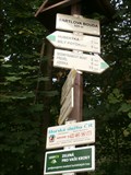
 view gallery view gallery E0.5 km E0.5 km
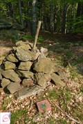
|   Turisticky ukazatel "BARTLOVA BOUDA" - 520 m n.m. Turisticky ukazatel "BARTLOVA BOUDA" - 520 m n.m.
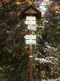
in Direction and Distance Arrows CZ: Rozcestnik turistickych tras na hornim konci obce Bily Potok.
EN: Direction and Distance Arrows of tourist paths in the upper part of the village Bily Potok. posted by:  jezevecjezevec jezevecjezevec location: Liberecký kraj, Czechia date approved: 07/30/2013 last visited: 07/29/2015 |
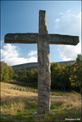 view gallery view gallery S0.5 km S0.5 km
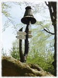
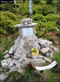
|  Millenium Cross at Bílý Potok / Kríž milénia u Bílého Potoka (North Bohemia, Czech Republic) Millenium Cross at Bílý Potok / Kríž milénia u Bílého Potoka (North Bohemia, Czech Republic)
in Christian Crosses This massive, plain Latin stone cross, was erected in 2000 above village Bílý Potok in Jizera Mts. (Jizerské Hory). posted by: Dorcadion Team location: Liberecký kraj, Czechia date approved: 06/20/2009 last visited: 05/16/2020 |
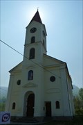 view gallery view gallery W0.8 km W0.8 km
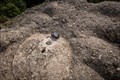
|  TB 0812-8 Bily Potok. kostel TB 0812-8 Bily Potok. kostel
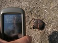
in Czech Geodetic Points Trigonometrický bod na severu Jizerských hor posted by: pavlikVB location: Liberecký kraj, Czechia date approved: 05/06/2012 last visited: 09/13/2011 |
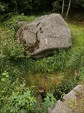 view gallery view gallery NE1.6 km NE1.6 km
|  Pramen hrabenky Marie / Spring of Countess Marie Pramen hrabenky Marie / Spring of Countess Marie
in Natural Springs CZ: Pramen u cervene znacene turisticke cesty mezi Hubertkou a Tisinou.
EN: Spring at the red marked tourist route between Hubertka and Tisina. posted by: jezevecjezevec location: Liberecký kraj, Czechia date approved: 07/22/2013 last visited: never |
 view gallery view gallery N1.6 km N1.6 km
| TB 0812-5 Kocici kameny in Czech Geodetic Points Trigonometrický bod na severu Jizerských hor posted by: pavlikVB location: Liberecký kraj, Czechia date approved: 05/06/2012 last visited: 07/23/2013 |
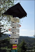
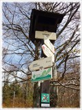 view gallery view galleryNE1.6 km | KCT: Tišina, Jizerské hory, CZ in Direction and Distance Arrows Tento rozcestník turistického znacení Klubu ceských turistu najdete na svazích Smrku. /// This signpost is a part of trailblazing of the Czech Hiking Club. You can view this signpost on the hillsides of Smrk. posted by:  Ursus PiPa Ursus PiPa location: Liberecký kraj, Czechia date approved: 05/24/2012 last visited: 07/29/2015 |
 view gallery view galleryN1.6 km |  No. 1935, chata Hubertka, CZ No. 1935, chata Hubertka, CZ
in Tourist Stamps Photos CZ: Turisticka znamka # 1935. Ustrednim motivem vypalene kresby je pohled na turistickou chatu Hubertka
EN: Tourist stamp # 1935. The main motive of the pyrography is a view on the tourist cottage Hubertka. posted by: jezevecjezevec location: Liberecký kraj, Czechia date approved: 07/30/2013 last visited: 07/27/2015 |
 view gallery view galleryN1.8 km | KCT: Hubertka, Jizerské hory, CZ in Direction and Distance Arrows Tento smerovník turistického znacení Klubu ceských turistu se nachází u horské boudy Hubertka v Jizerských horách.. /// This signpost is a part of trailblazing of the Czech Hiking Club. It is located close by the mountain hut called Hubertka. posted by: Ursus PiPa location: Liberecký kraj, Czechia date approved: 05/24/2012 last visited: 07/29/2015 |
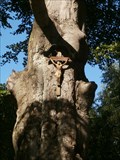 view gallery view galleryN1.8 km |  Krizovy buk u Hubertky, Bily Potok, CZ Krizovy buk u Hubertky, Bily Potok, CZ
in Historic Trees CZ: Krizovy buk u chaty Hubertka (Bily Potok).
EN: Cross beech near the cottage Hubertka (Bily Potok). posted by: jezevecjezevec location: Liberecký kraj, Czechia date approved: 08/04/2013 last visited: 04/23/2023 |
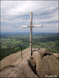
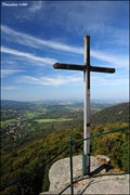 view gallery view galleryE1.9 km | Kríž na Palicníku / Cross at Palicník (Jizera Mts., Czech Republic) in Christian Crosses This plain, 3 m tall, wooden cross is located on one of the most beautiful mountain lookout points in Jizera Mountains (North Bohemia) - the summit of rocky formation called Palicník... posted by: Dorcadion Team location: Liberecký kraj, Czechia date approved: 09/29/2009 last visited: 07/29/2015 |
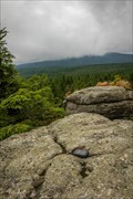
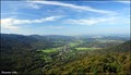 view gallery view galleryE1.9 km |  Palicník v Jizerských horách / Palicník in Jizera Mts. (Czech Republic) Palicník v Jizerských horách / Palicník in Jizera Mts. (Czech Republic)
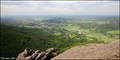
in Scenic Overlooks Rocky cliff Palicník is one of the most impressive view points in Jizera Mountains which offers magnificent vistas over all surrounding mountain landscape and also Frýdlant lowland. posted by: Dorcadion Team location: Liberecký kraj, Czechia date approved: 09/29/2009 last visited: 07/29/2015 |
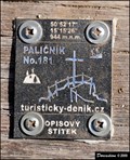 view gallery view galleryE1.9 km |  N50° 52' 17" E15° 15' 26" - Summit of Palicník (Jizera Mts., Czech Republic) N50° 52' 17" E15° 15' 26" - Summit of Palicník (Jizera Mts., Czech Republic)
in Permanent Geographic Coordinates Small metal tablet with coordinates and altitude you can find at summit of granite cliff Palicník in Jizera Mountains (Jizerské hory) in North Bohemia... posted by: Dorcadion Team location: Liberecký kraj, Czechia date approved: 09/29/2009 last visited: 07/29/2015 |
 view gallery view galleryE1.9 km | TB 0812-11 Palecnik in Czech Geodetic Points Trigonometricky bod v na skale na odbocce z turisticky znacene cesty. posted by: jezevecjezevec location: Liberecký kraj, Czechia date approved: 07/31/2013 last visited: 07/29/2015 |
 view gallery view gallery SW2.1 km SW2.1 km
| Cross at "Frýdlant Battlements" / Kríž na Frýdlantském cimburí (Czech Republic) in Christian Crosses This massive wooden cros is located on the beautiful mountain lookout point - the summit of rocky formation Frýdlant Battlements (in Czech: Frýdlantské cimburí) in Jizera Mountains (North Bohemia). posted by: Dorcadion Team location: Liberecký kraj, Czechia date approved: 06/10/2009 last visited: 09/29/2015 |
 view gallery view gallerySW2.1 km | "Frýdlant Battlements" in Jizera Mts. / Frýdlantské cimburí v Jizerských horách (Czech Republic) in Scenic Overlooks The Frýdlant Battlements (In Czech: Frýdlantské cimburí) offers beautiful vistas over Hejnice, Frýdlant upland and northern part of Jizera Mountains (North Bohemia). posted by: Dorcadion Team location: Liberecký kraj, Czechia date approved: 06/10/2009 last visited: 09/27/2015 |
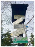 view gallery view galleryE2.1 km | KCT: Pod Klínovým vrchem, Jizerské hory, CZ in Direction and Distance Arrows Rozcestník turistického znacení Klubu ceských turistu. Nachází se nedaleko známé skalní vyhlídky "Palicník". /// This signpost is a part of trailblazing of the Czech Hiking Club. It is located near the famous rocky lokoout called "Palicník" posted by: Ursus PiPa location: Liberecký kraj, Czechia date approved: 05/24/2012 last visited: 07/29/2015 |
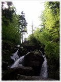 view gallery view gallerySW2.3 km |  Cerný vodopád, Jizerské hory, CZ Cerný vodopád, Jizerské hory, CZ
in Waterfalls Cerný vodopád na Cerném potoce v Jizerských horách. /// The Black waterfall on the Black creek on the northern slope of the Jizera Mountains. posted by: Ursus PiPa location: Liberecký kraj, Czechia date approved: 02/14/2012 last visited: 07/28/2015 |
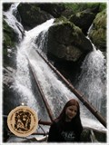 view gallery view gallerySW2.3 km | No. 1198, Cerný vodopád - Jizerské hory, CZ in Tourist Stamps Photos Turistická známka zobrazuje vodopád na Cerném potoce. /// Tourist stamp shows the waterfall of Cerný potok. posted by: Ursus PiPa location: Liberecký kraj, Czechia date approved: 02/07/2012 last visited: 07/28/2015 |
 view gallery view gallery SE2.6 km SE2.6 km
|  1992' Air Crash at Smedavská Mt. / Letecká havárie na Smedavské hore v roce 1992 (Czech Republic) 1992' Air Crash at Smedavská Mt. / Letecká havárie na Smedavské hore v roce 1992 (Czech Republic)
in Plane Crash Sites In April 23rd, 1992 two small French sport planes crashed during snowstorm on the ridge of Jizera Mountains (Jizerské hory) under summit of Smedavská Mountain. All four crew members tragically died... posted by: Dorcadion Team location: Liberecký kraj, Czechia date approved: 06/10/2009 last visited: 03/20/2016 |
 view gallery view galleryS2.7 km | TB 0812-14 Smedavsky vrch in Czech Geodetic Points Trigonometrický bod v Jizerských horách posted by: alicek location: Liberecký kraj, Czechia date approved: 08/20/2023 last visited: never |
 view gallery view galleryN3.1 km | Turisticky ukazatel "U CERVENEHO BUKU" in Direction and Distance Arrows CZ: Rozcestnik turistickych tras na lesni krizovatce na uboci hory Smrk.
EN: Direction and Distance Arrows of tourist paths on the wood crossing on the mountainside of the mountain Smrk. posted by: jezevecjezevec location: Liberecký kraj, Czechia date approved: 07/30/2013 last visited: never |
 view gallery view galleryE3.2 km | Nebeský žebrík - dolní rozcestí / Heavenly Ladder - Lower crossroad (Jizera Mts., Czech Republic) in Direction and Distance Arrows The wooden signpole with several distance arrows assigns the lower crossroad under so called Nebeský žebrík (Heavenly Ladder), the very steep touristic trail to the summit of Smrk Mt. in Jizera Mountains. posted by: Dorcadion Team location: Liberecký kraj, Czechia date approved: 09/29/2009 last visited: 08/23/2021 |
 view gallery view gallerySW3.4 km | TB 0812-10 Oresnik in Czech Geodetic Points Trigonometrický bod v Jizerských horách posted by: alicek location: Liberecký kraj, Czechia date approved: 07/31/2023 last visited: never |
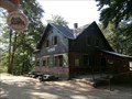
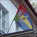 view gallery view galleryW3.4 km |  Hejnice municipal flag / Vlajka mesta Hejnice (North Bohemia) Hejnice municipal flag / Vlajka mesta Hejnice (North Bohemia)
in Municipal Flags The municipal flag of the town Hejnice (Jizera Mts., North Bohemia) can be found on the town's hall building... posted by: Dorcadion Team location: Liberecký kraj, Czechia date approved: 11/02/2009 last visited: 06/04/2023 |
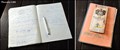 view gallery view galleryNE3.4 km |  Look-out Tower at Smrk Mt. Guestbook / Návštevní kniha rozhledny na Smrku (Jizera Mts., Czech Republic) Look-out Tower at Smrk Mt. Guestbook / Návštevní kniha rozhledny na Smrku (Jizera Mts., Czech Republic)
in Guest Books Guestbook you can find in visitors room at the base of look-out Tower at Smrk Mt., the highest peak of Jizera Mts. in North Bohemia... posted by: Dorcadion Team location: Liberecký kraj, Czechia date approved: 09/29/2009 last visited: 07/26/2013 |
|