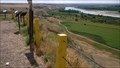
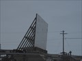
 view gallery view gallery E56.5 km E56.5 km
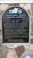
|   Checkerboard Hill Lookout Checkerboard Hill Lookout
in Saskatchewan Historical Markers Located Northwest of Leader. Multiple description boards that describe many area subjects including history. posted by:  Altima Voyageur Altima Voyageur location: Saskatchewan, Canada date approved: 10/19/2017 last visited: never |
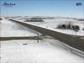
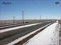
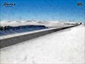 view gallery view gallery N64.5 km N64.5 km
|  Sibbald Highway Web Camera - Sibbald, Alberta Sibbald Highway Web Camera - Sibbald, Alberta
in Web Cameras This Alberta Highways Webcam is mounted on a steel tower along Highway 9 about midway between Oyen and Sibbald. posted by:  T0SHEA T0SHEA location: Alberta, Canada date approved: 03/03/2014 last visited: 08/04/2014 |
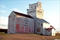
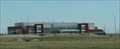
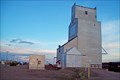 view gallery view galleryE65 km |  Saskatchewan Wheat Pool Elevator - Leader, Saskatchewan Saskatchewan Wheat Pool Elevator - Leader, Saskatchewan
in Grain Elevators Leader can be found about 160 km. northwest of Swift Current, Saskatchewan, on Highways 32 and 21. posted by: T0SHEA location: Saskatchewan, Canada date approved: 02/01/2013 last visited: 02/28/2014 |
 view gallery view galleryE65.7 km | St John's School, NE 1/4 4-21-36 W3M in Saskatchewan Historical Markers Just along the side of the road. posted by: Altima Voyageur location: Saskatchewan, Canada date approved: 06/19/2013 last visited: never |
 view gallery view galleryE65.8 km | Smith Barn in Saskatchewan Historical Markers This scaled down replica of the actual barn sits near the town of Leader tourist booth located on Hwy 21 and the corner of 5 Avenue East. The actual barn site is located km's North West of Leader. posted by: Altima Voyageur location: Saskatchewan, Canada date approved: 09/16/2017 last visited: never |
 view gallery view galleryN66.5 km | Oyen Highway Web Camera - Oyen, Alberta in Web Cameras This Alberta Highways Webcam is mounted on a steel tower along Highway 9 about midway between Cereal and Oyen. posted by: T0SHEA location: Alberta, Canada date approved: 03/03/2014 last visited: 07/28/2014 |
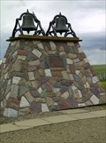 view gallery view galleryE67.8 km | Dedication to Pioneer Families and Oblate Fathers in Saskatchewan Historical Markers Located in hamlet of Liebenthal. Junctions of Hwy 21 and Hwy 321. posted by: Altima Voyageur location: Saskatchewan, Canada date approved: 06/26/2013 last visited: 06/30/2014 |
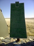 view gallery view gallery NE70.8 km NE70.8 km
| Battleford/Red Deer Forks Trail in Saskatchewan Historical Markers One of many trails that cross the prairies. The Battleford-Red Deer Forks Trail lies near. posted by: Altima Voyageur location: Saskatchewan, Canada date approved: 05/08/2012 last visited: never |
 view gallery view galleryE74 km | Paterson Elevator - Prelate Saskatchewan in Grain Elevators Where on earth is Prelate? Well, it's around 9 km. west of Sceptre, which is 19 km west of Portreeve, which is 47 km. northwest of Cabri, which is another 63 km. or so up Highway 32 from Speedy Crick, Saskatchewan. posted by: T0SHEA location: Saskatchewan, Canada date approved: 02/05/2013 last visited: 02/25/2014 |
 view gallery view gallery W74.8 km W74.8 km
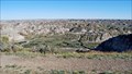
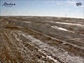
|  Dinosaur Provincial Park - Alberta, Canada Dinosaur Provincial Park - Alberta, Canada
in Paleontology and Fossils Southeastern Alberta, about 200 kilometres more or less straight east of Calgary is where one will find this World Heritage Site, in the badlands of the Red Deer River. posted by: T0SHEA location: Alberta, Canada date approved: 01/04/2014 last visited: 07/13/2019 |
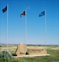 view gallery view galleryW74.8 km |  Dinosaur Provincial Park - Alberta, Canada Dinosaur Provincial Park - Alberta, Canada
in State/Provincial Parks Southeastern Alberta, about 200 kilometres more or less straight east of Calgary is where one will find this Provincial Park and World Heritage Site, in the badlands of the Red Deer River. posted by: T0SHEA location: Alberta, Canada date approved: 01/02/2014 last visited: 07/15/2019 |
 view gallery view galleryW74.8 km |  Dinosaur Provincial Park - Alberta, Canada Dinosaur Provincial Park - Alberta, Canada
in Places of Geologic Significance Southeastern Alberta, about 200 kilometres more or less straight east of Calgary is where one will find this World Heritage Site, in the badlands of the Red Deer River. posted by: T0SHEA location: Alberta, Canada date approved: 01/04/2014 last visited: 07/13/2019 |
 view gallery view galleryW74.8 km |  Dinosaur Provincial Park - Brooks, Alberta Dinosaur Provincial Park - Brooks, Alberta
in Official Local Tourism Attractions Southeastern Alberta, about 200 kilometres more or less straight east of Calgary is where one will find this Provincial Park and World Heritage Site, in the badlands of the Red Deer River. posted by: T0SHEA location: Alberta, Canada date approved: 01/04/2014 last visited: 07/15/2019 |
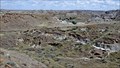 view gallery view galleryW74.8 km |  Dinosaur Provincial Park - Alberta, Canada Dinosaur Provincial Park - Alberta, Canada
in World Heritage Sites Southeastern Alberta, about 200 kilometres more or less straight east of Calgary is where one will find this World Heritage Site, in the badlands of the Red Deer River. posted by: T0SHEA location: Alberta, Canada date approved: 01/01/2014 last visited: 07/13/2019 |
 view gallery view galleryW74.8 km |  Dinosaur Provincial Park - Alberta, Canada Dinosaur Provincial Park - Alberta, Canada
in Wikipedia Entries Southeastern Alberta, about 200 kilometres more or less straight east of Calgary is where one will find this World Heritage Site, in the badlands of the Red Deer River. posted by: T0SHEA location: Alberta, Canada date approved: 01/02/2014 last visited: 07/13/2019 |
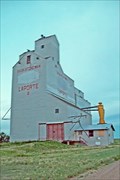 view gallery view galleryNE80.1 km | Saskatchewan Wheat Pool B - Laporte, Saskatchewan in Grain Elevators Along Highway 44, the tiny hamlet of Laporte is 39 short km. east of the Alberta border. posted by: T0SHEA location: Saskatchewan, Canada date approved: 02/07/2013 last visited: 02/22/2014 |
 view gallery view gallery SW81.6 km SW81.6 km
| Suffield Highway Web Camera - Suffield, Alberta in Web Cameras This Alberta Highways Webcam is mounted on a steel tower on the north side of Highway 1 near Suffield, AB. posted by: T0SHEA location: Alberta, Canada date approved: 02/28/2014 last visited: 06/07/2014 |
 view gallery view gallery S82.1 km S82.1 km
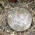
|  GSD 68A174 - Bowell (Alberta) GSD 68A174 - Bowell (Alberta)
in Canadian Benchmarks Benchmark 68A174 between Redcliff and Suffield, Alberta posted by: dubious20 location: Alberta, Canada date approved: 05/28/2006 last visited: 09/27/2006 |
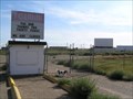 view gallery view galleryS84.8 km |  The Gemini Drive-In - Medicine Hat, Alberta, Canada( Abandoned) The Gemini Drive-In - Medicine Hat, Alberta, Canada( Abandoned)
in Drive-In Movie Theaters The End.
Thanks for thirty years.
Almost brings a tear. posted by: Softheads location: Alberta, Canada date approved: 09/15/2005 last visited: 09/27/2006 |
 view gallery view galleryS85.1 km |  Redcliff Drive-In - Redcliff, Alberta Redcliff Drive-In - Redcliff, Alberta
in Closed Drive-In Theatres This is the closed drive-in at Redcliff, Alberta. posted by: wildwoodke location: Alberta, Canada date approved: 04/22/2010 last visited: never |
 view gallery view gallerySW85.3 km | Tilley Highway Web Camera - Tilley, Alberta in Web Cameras This Alberta Highways Webcam is mounted on a steel tower on the west side of Highway 1 near Tilley, AB. posted by: T0SHEA location: Alberta, Canada date approved: 02/28/2014 last visited: 06/07/2014 |
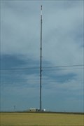 view gallery view galleryS85.3 km |  CHAT-TV Channel 6 -- Medicine Hat AB CAN CHAT-TV Channel 6 -- Medicine Hat AB CAN
in Radio and Television Transmitter Towers The tall transmitter for CHAT-TV Channel 6, located along the Trans-Canada Highway near Redcliff AB posted by: Benchmark Blasterz location: Alberta, Canada date approved: 02/01/2022 last visited: 02/22/2022 |
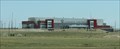 view gallery view galleryS85.3 km | Canalta Centre (now Co-Op Place) -- Medicine Hat AB CAN in Wikipedia Entries When Blasterz were in Medicine Hat, this was the Canalta Centre. In 2020 it gained a new name: Co-Op Place. It is still the home of the Medicine Hat Tigers of the Canadian Western Hockey League posted by: Benchmark Blasterz location: Alberta, Canada date approved: 06/06/2023 last visited: 07/24/2019 |
 view gallery view galleryS85.3 km |  "Regional Event Centre to be Renamed Co-Op Place" -- Medicine Hat AB CAN "Regional Event Centre to be Renamed Co-Op Place" -- Medicine Hat AB CAN
in News Article Locations When Blasterz were in Medicine Hat, this was the Canalta Centre. In 2020 it gained a new name: Co-Op Place. It is still the home of the Medicine Hat Tigers of the Canadian Western Hockey League. posted by: Benchmark Blasterz location: Alberta, Canada date approved: 06/06/2023 last visited: 07/24/2019 |
 view gallery view galleryS85.3 km |  Canalta Centre (now Co-Op Place) -- Medicine Hat AB CAN Canalta Centre (now Co-Op Place) -- Medicine Hat AB CAN
in Professional Sports Venues When Blasterz were in Medicine Hat, this was the Canalta Centre. In 2020 it gained a new name: Co-Op Place. It is still the home of the Medicine Hat Tigers of the Canadian Western Hockey League. posted by: Benchmark Blasterz location: Alberta, Canada date approved: 06/07/2023 last visited: 07/24/2019 |
|