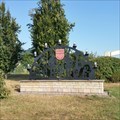
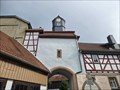
 view gallery view gallery N9.8 km N9.8 km
|   Salt Mine Merkers, Merkers, Germany Salt Mine Merkers, Merkers, Germany
in Salt Pans and Mines Large salt mine, still in use after over 100 years of exploration. posted by:  Axel-F Axel-F location: Thüringen, Germany date approved: 09/11/2018 last visited: 02/03/2020 |
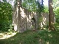
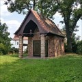 view gallery view galleryN10 km |  Friedhof Kapelle Merkers - Merkers-Kiesselbach, Germany. Friedhof Kapelle Merkers - Merkers-Kiesselbach, Germany.
in Cemetery Chapels Cemetery Chapel on old cemetery, without a real name, in Merkers. posted by: Axel-F location: Thüringen, Germany date approved: 08/29/2018 last visited: 08/08/2018 |
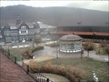 view gallery view gallery NE10.6 km NE10.6 km
|  Gradiergarten Bad Salzungen Gradiergarten Bad Salzungen
in Web Cameras Webam mit Blick in den Gradiergarten Bad Salzungen mit Gradierwerk und Eingang Solewelt /
Webcam with view of the Gradiergarten Bad Salzungen with thorn house and entrance Solewelt posted by: Team KarlZink location: Thüringen, Germany date approved: 12/11/2018 last visited: never |
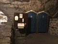 view gallery view gallery NW11.6 km NW11.6 km
|  Deepest Outhouse in Germany - Vacha, TH-DE Deepest Outhouse in Germany - Vacha, TH-DE
in Outhouses Outhouse in the kali mine of Merkers at 800 m below surface. posted by: André de Montbard location: Thüringen, Germany date approved: 11/29/2019 last visited: 10/19/2020 |
 view gallery view gallery S12.2 km S12.2 km
|  Schloß Kaltennordheim Schloß Kaltennordheim
in Castles Schloß Kaltennordheim posted by: cutmaster01 location: Thüringen, Germany date approved: 07/26/2023 last visited: never |
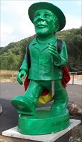 view gallery view galleryNW13.7 km |  Der Einheitsmann - Vacha, Thüringen, Germany Der Einheitsmann - Vacha, Thüringen, Germany
in Figurative Public Sculpture Der Einheitsmann in Vacha/Thüringen posted by: jotheonly location: Thüringen, Germany date approved: 09/04/2018 last visited: never |
 view gallery view galleryNW14.6 km |  Ulsterbrücke, Unterbreizbach, Germany Ulsterbrücke, Unterbreizbach, Germany
in Hiking Path Footbridges Diese hölzerne Brücke führt den Rhön-Rundweg 4 über den Fluss Ulster *** This wooden bridge will lead you across the river Ulster on the path "Rhön-Rundweg 4" posted by: 4spring location: Thüringen, Germany date approved: 09/05/2017 last visited: 04/30/2017 |
 view gallery view gallery W15.6 km W15.6 km
|  Point Alpha Memorial - Hessen/Thüringen, Germany Point Alpha Memorial - Hessen/Thüringen, Germany
in Monuments of the Eastern Freedomfights The Point Alpha Memorial encompasses preserved and partially reconstructed border installations of the GDR era. It is a unique testament to the power struggle between two political systems posted by:  Eibacher Kuckuck Eibacher Kuckuck location: Thüringen, Germany date approved: 07/27/2015 last visited: 12/06/2021 |
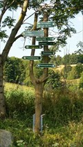
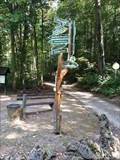 view gallery view galleryNE17.1 km |  Wegweiser am Wernerplatz - 36448 Bad Liebenstein, TH, Germany Wegweiser am Wernerplatz - 36448 Bad Liebenstein, TH, Germany
in Direction and Distance Arrows Wegweiser am Wernerplatz in Bad Liebenstein posted by: jotheonly location: Thüringen, Germany date approved: 09/17/2018 last visited: never |
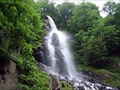 view gallery view gallery E20 km E20 km
|  Trusetaler Wasserfall, Trusetal - Thüringen - Germany Trusetaler Wasserfall, Trusetal - Thüringen - Germany
in Man-made Waterfalls Trusetaler Wasserfall - in Trusetal/Thüringen ..........................
Trusetaler waterfall - in Trusetal/Thuringia posted by: jotheonly location: Thüringen, Germany date approved: 02/03/2016 last visited: 05/27/2023 |
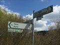 view gallery view gallery SW21.2 km SW21.2 km
| R3 Radwegweiser, Hilders, Germany in Direction and Distance Arrows Wegweiser für Radfahrer auf dem Hessischen Radfernweg R3, auch Bahnradweg und Milseburgradweg genannt *** Direction sign for bicycle tourist on the bicycle long road R3, this part is also called Bahnradweg and Milseburgradweg posted by: 4spring location: Hessen, Germany date approved: 09/24/2017 last visited: 04/29/2017 |
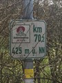 view gallery view gallerySW21.2 km |  425 m ü. NN, Hilders, Germany 425 m ü. NN, Hilders, Germany
in Elevation Signs Das Schild zeigt die aktuelle Höhe und auch die Richtungen zu den nächsten Orten, die man ab dieser Kreuzung erreichen kann *** This sign shows you your current elevation above sea level and the next cities which you can reach from this intersection posted by: 4spring location: Hessen, Germany date approved: 09/18/2017 last visited: 04/29/2017 |
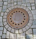 view gallery view galleryE21.4 km |  "Stadt Schmalkalden" Manhole Cover - 98574 Schmalkalden, TH, Germany "Stadt Schmalkalden" Manhole Cover - 98574 Schmalkalden, TH, Germany
in Unique Manhole Covers Manhole cover in Schmalkalden/Thüringen.....Manhole cover in Schmalkalden / Thuringia posted by: jotheonly location: Thüringen, Germany date approved: 09/07/2018 last visited: never |
 view gallery view galleryNW21.6 km |  Walterskirche (former church of Waldradeberg) - Unterneurode, Germany Walterskirche (former church of Waldradeberg) - Unterneurode, Germany
in Remains of Settlements Remains of a the Walterskirche of the lost hamlet of Waldradeberg posted by: Axel-F location: Hessen, Germany date approved: 12/03/2018 last visited: 01/30/2019 |
 view gallery view galleryNE22.5 km | Wegweiser am Gehege - 98596 Brotterode, Th, Germany in Direction and Distance Arrows Wegweiser zum Gehege oberhalb Brotterode posted by: jotheonly location: Thüringen, Germany date approved: 09/17/2018 last visited: never |
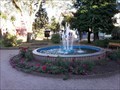 view gallery view galleryNE23 km |  Springbrunnen - Bad Vilbeler Platz, Brotterode, TH, Germany Springbrunnen - Bad Vilbeler Platz, Brotterode, TH, Germany
in Fountains Springbrunnen auf dem Bad Vilbeler Platz in Brotterode ....
Fountains on the Bad Vilbeler Platz in Brotterode posted by: jotheonly location: Thüringen, Germany date approved: 09/18/2018 last visited: 08/10/2018 |
 view gallery view galleryE24.3 km |  LARGEST Cowbell - Kleinschmalkalden, Thüringen, Germany LARGEST Cowbell - Kleinschmalkalden, Thüringen, Germany
in Superlatives In Kleinschmalkalden kann man die größte Kuhglocke der Welt besichtigen. | In Kleinschmalkalden you can visit the largest cowbell in the world. posted by: Eibacher Kuckuck location: Thüringen, Germany date approved: 08/19/2013 last visited: 11/15/2012 |
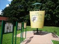
 view gallery view galleryN24.3 km |  Informationsstand Lindenhauptkopf Informationsstand Lindenhauptkopf
in Birdwatching Locations Naturschutzgebiet „Dankmarshäuser Rhäden“ 250 Vogelarten posted by: D1k74 location: Thüringen, Germany date approved: 03/06/2013 last visited: 02/21/2017 |
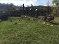
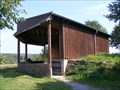
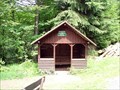
 view gallery view galleryNE24.5 km |  Schutzhütte am Forstrettungspunkt GTH-6410 - Ruhla, TH, Germany Schutzhütte am Forstrettungspunkt GTH-6410 - Ruhla, TH, Germany
in Remote Backcountry Shelters Schutzhütte an der Weinstraße im Thüringer Wald......Refuge on the Wine Route in the Thuringian Forest posted by: jotheonly location: Thüringen, Germany date approved: 09/08/2018 last visited: never |
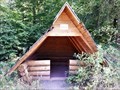
 view gallery view galleryNE24.8 km | Schutzhütte Venetianerstein - Thüringer Wald, Thüringen, Germany in Remote Backcountry Shelters Schutzhütte auf dem Rennsteig-Wanderweg am Venetianerstein --- Refuge on the Rennsteig hiking trail at Venetianerstein posted by: jotheonly location: Thüringen, Germany date approved: 02/21/2018 last visited: never |
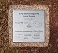 view gallery view galleryNE24.9 km |  N 50° 55,9353' E 10° 19,0768' - GPS-Referenzpunkt Hohe Sonne — Eisenach, Germany N 50° 55,9353' E 10° 19,0768' - GPS-Referenzpunkt Hohe Sonne — Eisenach, Germany
in Permanent Geographic Coordinates GPS reference point determined by the Thuringian State Office for Surveying and Geoinformation posted by: prussel location: Thüringen, Germany date approved: 06/29/2017 last visited: never |
 view gallery view galleryNE24.9 km | 432,5 m NHN - GPS-Referenzpunkt Hohe Sonne — Eisenach, Germany in Elevation Signs GPS reference point determined by the 'Thüringer Landesamt für Vermessung und Geoinformation' (Thuringian State Office for Surveying and Geoinformation), showing the coordinates and a height of 432,5 m NHN posted by: prussel location: Thüringen, Germany date approved: 06/27/2017 last visited: never |
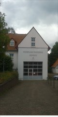 view gallery view galleryS25.3 km |  Feuerwehrhaus Seiferts/Rhön Feuerwehrhaus Seiferts/Rhön
in Firehouses Das Feuerwehrhaus der Freiwilligen Feuerwehr Seiferts/Ehrenberg in der Rhön posted by: welllife location: Hessen, Germany date approved: 08/26/2014 last visited: never |
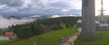 view gallery view galleryNE25.7 km | Großer Inselsberg - 360° HD in Web Cameras Webcam on the Großer Inselsberg 916m above sea level /
Webcam auf dem Großen Inselsberg 916m über dem Meer posted by: Team KarlZink location: Thüringen, Germany date approved: 12/23/2018 last visited: 06/06/2023 |
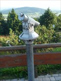 view gallery view galleryNE25.7 km |  Münzfernrohr am Inselsberg - Thüringen, Germany Münzfernrohr am Inselsberg - Thüringen, Germany
in Coin-Op Binoculars Dieses Münzfernrohr steht auf dem Großen Inselsberg in Thüringen | This Coin-Op Binocular is located on the Großer Inselsberg in Thüringen posted by: Eibacher Kuckuck location: Thüringen, Germany date approved: 08/11/2013 last visited: 08/10/2018 |
|