 view gallery view gallery N5.6 km N5.6 km
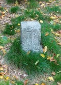
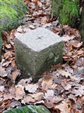
|   TP Glaskopf — Glashütten, Germany TP Glaskopf — Glashütten, Germany
in German Trigonometric Points Trigonometric Point on the summit of the Glaskopf, an elevation with a height of 686,8 m ü. NHN above Glashütten and Oberems in the Taunus Mountains posted by:  prussel prussel location: Hessen, Germany date approved: 04/21/2020 last visited: never |
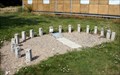 view gallery view gallery S6.3 km S6.3 km
|  Sternwarte Langenhain Sundial - Hofheim-Langenhain, Germany Sternwarte Langenhain Sundial - Hofheim-Langenhain, Germany
in Sundials An analemmatic sundial in Hofheim-Langenhain. posted by: FBBHaegar location: Hessen, Germany date approved: 08/12/2009 last visited: 03/21/2021 |
 view gallery view gallery E6.8 km E6.8 km
|  Opel Zoo Kronberg,Hessen, Germany Opel Zoo Kronberg,Hessen, Germany
in Zoos [DE] Der Opel-Zoo (von Opel Hessische Zoostiftung) ist neben dem Zoo Frankfurt der zweite größere zoologische Garten im Rhein-Main-Gebiet.
[EN] The Opel-Zoo (Hessian of Opel Zoostiftung) is next to the Frankfurt Zoo, the second major zoological garden in the Rhine-Main area. posted by:  kaschper69 kaschper69 location: Hessen, Germany date approved: 04/06/2016 last visited: 04/02/2016 |
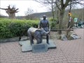 view gallery view galleryE6.8 km |  Goerg von Opel - Kronberg, Hessen, Germany Goerg von Opel - Kronberg, Hessen, Germany
in Statues of Historic Figures [DE] Bronzestatue von Georg von Opel im Opel-Zoo in Kronberg.
[EN] Bronze statue of Georg von Opel in the Opel Zoo in Kronberg. posted by: kaschper69 location: Hessen, Germany date approved: 04/07/2016 last visited: 04/04/2016 |
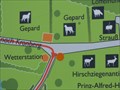
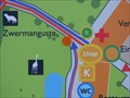 view gallery view galleryE6.8 km |  Lageplan Nähe Haupteingang Opel-Zoo, Kronberg, Hessen, Germany Lageplan Nähe Haupteingang Opel-Zoo, Kronberg, Hessen, Germany
in 'You Are Here' Maps [DE] Karte mit dem eigenen Standort im Opel-Zoo in Kronberg.
[EN] Map with own location in the Opel Zoo in Kronberg. posted by: kaschper69 location: Hessen, Germany date approved: 04/04/2016 last visited: 04/04/2016 |
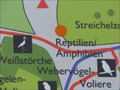 view gallery view galleryE6.9 km | Lageplan Nähe Reptilien Opel-Zoo, Kronberg, Hessen, Germany in 'You Are Here' Maps [DE] Karte mit dem eigenen Standort im Opel-Zoo in Kronberg. [EN] Map with own location in the Opel Zoo in Kronberg. posted by: kaschper69 location: Hessen, Germany date approved: 04/04/2016 last visited: 04/04/2016 |
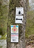
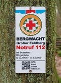
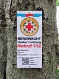 view gallery view galleryN7.1 km |  N 50,22987° O 8,42411° — Zacken - Glashütten, Germany N 50,22987° O 8,42411° — Zacken - Glashütten, Germany
in Permanent Geographic Coordinates Coordinates and emergency number at the "Zacken", a 640 m high slate elevation east of the Glashütten district of Oberems. It is a popular training ground for mountaineers with a total of 13 climbing routes posted by: prussel location: Hessen, Germany date approved: 04/21/2020 last visited: never |
 view gallery view galleryE7.1 km |  Georg von Opel - Opel Zoo - Kronberg, Hesse, Germany Georg von Opel - Opel Zoo - Kronberg, Hesse, Germany
in Relief Art Sculptures Relief von Georg von Opel im Opel-Zoo in Kronberg. posted by: kaschper69 location: Hessen, Germany date approved: 06/09/2018 last visited: 06/07/2018 |
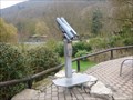 view gallery view galleryE7.1 km |  Coin-Op Binocular Opel-Zoo, Kronberg, Hesse, Germany Coin-Op Binocular Opel-Zoo, Kronberg, Hesse, Germany
in Coin-Op Binoculars [DE] Fernglas auf einer kleinen Aussichtsplattform im Opel-Zoo Kronberg.
[EN] Binoculars on a small observation deck at the Opel Zoo Kronberg. posted by: kaschper69 location: Hessen, Germany date approved: 04/24/2016 last visited: 04/22/2016 |
 view gallery view galleryE7.2 km | Lageplan Nähe Wetterstation Opel-Zoo, Kronberg, Hessen, Germany in 'You Are Here' Maps [DE] Karte mit dem eigenen Standort im Opel-Zoo in Kronberg. [EN] Map with own location in the Opel Zoo in Kronberg. posted by: kaschper69 location: Hessen, Germany date approved: 04/04/2016 last visited: 04/04/2016 |
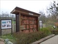 view gallery view galleryE7.2 km |  Insektenhotel Opel-Zoo, Kronberg, Hessen, Germany Insektenhotel Opel-Zoo, Kronberg, Hessen, Germany
in Insect Hotels [DE] Insektenhotel im Opel-Zoo in Kronberg.
[EN] Insect Hotel at the Opel Zoo in Kronberg. posted by: kaschper69 location: Hessen, Germany date approved: 04/04/2016 last visited: 04/04/2016 |
 view gallery view galleryE7.2 km | N 50,19282° O 8,48739° — Kocherfels Falkenstein - Königstein im Taunus, Germany in Permanent Geographic Coordinates Coordinates and emergency number at the hiking trail "3 Burgen Weg", close to the lookout point "Kocherfels" near Königstein im Taunus posted by: prussel location: Hessen, Germany date approved: 06/19/2021 last visited: never |
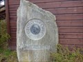
 view gallery view galleryN7.6 km | TP Zacken-Beilstein-Steig — Glashütten, Germany in German Trigonometric Points Trigonometric Point at the hiking trail "Zacken-Beilstein-Steig" in the Taunus, east of Glashütten posted by: prussel location: Hessen, Germany date approved: 04/21/2020 last visited: never |
 view gallery view galleryN7.6 km | N 50,23311° O 8,42125° — Glashütten, Germany in Permanent Geographic Coordinates Coordinates and emergency number at the at the crossing of several hiking trails between Oberreifenberg, a district of the municipality of Schmitten and the Glashütten district of Oberems posted by: prussel location: Hessen, Germany date approved: 04/21/2020 last visited: never |
 view gallery view gallery NE7.9 km NE7.9 km
| Der Altkönig - 798,2 m ü. NHN in German Trigonometric Points Auf dem leicht bewaldetem Gipfelplateau des Altkönigs befindet sich ein trigonometrischer Punkt. Bei guten Sichtbedingungen fällt der Blick zwischen Bäumen hindurch unter anderem in die Oberrheinische Tiefebene und nach Frankfurt am Main. posted by: Hide*seek location: Hessen, Germany date approved: 10/06/2015 last visited: 07/27/2019 |
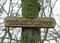
 view gallery view galleryE8.2 km | TP Bürgelplatte — Kronberg im Taunus, Germany in German Trigonometric Points Trigonometric Point on top of the striking greenschist rock formation "Bürgelplatte" posted by: prussel location: Hessen, Germany date approved: 02/26/2019 last visited: 04/18/2021 |
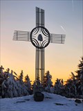
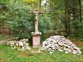 view gallery view gallery SE8.2 km SE8.2 km
|  Königsteiner Kreuz — Hofheim am Taunus, Germany Königsteiner Kreuz — Hofheim am Taunus, Germany
in Christian Crosses Wayside cross from 1792 at the Kapelleberg on the way to the Bergkapelle (mountain chapel) posted by: prussel location: Hessen, Germany date approved: 11/13/2012 last visited: 07/01/2014 |
 view gallery view gallerySE8.2 km |  Königsteiner Kreuz — Hofheim am Taunus, Germany Königsteiner Kreuz — Hofheim am Taunus, Germany
in Deutsche Denkmallisten - German Monument Registers Wayside cross from 1792 at the Kapelleberg posted by: prussel location: Hessen, Germany date approved: 11/12/2012 last visited: 07/01/2014 |
 view gallery view galleryE8.2 km | N 50,19647° O 8,500006° — Bürgelplatte - Kronberg im Taunus, Germany in Permanent Geographic Coordinates Coordinates and emergency number at the "Bürgelplatte" in the forest near Kronberg im Taunus posted by: prussel location: Hessen, Germany date approved: 02/13/2019 last visited: never |
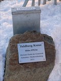
 view gallery view galleryE8.2 km |  446 m - Bürgelplatte — Kronberg im Taunus, Germany 446 m - Bürgelplatte — Kronberg im Taunus, Germany
in Elevation Signs Elevation Sign at the striking greenschist rock formation "Bürgelplatte" posted by: prussel location: Hessen, Germany date approved: 03/02/2019 last visited: never |
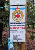
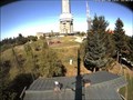 view gallery view galleryNE8.2 km |  Webcam Großer Feldberg, Schmitten - Hessen / Germany Webcam Großer Feldberg, Schmitten - Hessen / Germany
in Web Cameras Webcam on the highest mountain of Taunus posted by: Iris & Harry location: Hessen, Germany date approved: 09/02/2016 last visited: 02/09/2023 |
 view gallery view galleryNE8.2 km |  Public Playground at Großer Feldberg, Schmitten - Hessen / Germany Public Playground at Großer Feldberg, Schmitten - Hessen / Germany
in Public Playgrounds Highest playground at the Taunus mountain range. posted by: Iris & Harry location: Hessen, Germany date approved: 08/29/2016 last visited: 02/09/2023 |
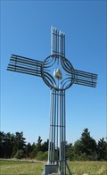 view gallery view galleryNE8.4 km | Cross at Großer Feldberg, Schmitten - Hessen / Germany in Christian Crosses Cross at the highest mountain of the Taunus mountain range. posted by: Iris & Harry location: Hessen, Germany date approved: 08/30/2016 last visited: 06/19/2021 |
 view gallery view galleryNE8.4 km | Großer Feldberg — Schmitten, Germany. 879,5 m in Elevation Signs The Großer Feldberg is the highest mountain (879,5 metres) in the Taunus mountains. It is situated in the Hochtaunuskreis district in Hessen, Germany posted by: prussel location: Hessen, Germany date approved: 03/13/2013 last visited: 07/31/2020 |
 view gallery view galleryNE8.4 km |  Großer Feldberg — Schmitten, Germany Großer Feldberg — Schmitten, Germany
in Mountain Summits The Großer Feldberg is the highest mountain (879,5 metres) in the Taunus mountains. It is situated in the Hochtaunuskreis district in Hessen, Germany posted by: prussel location: Hessen, Germany date approved: 03/14/2013 last visited: 07/31/2020 |
|