 view gallery view gallery E8 km E8 km
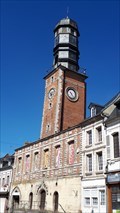
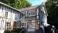
|   Belfries of Belgium and France - Beffroi de l’ancienne maison communale de Doullens, France, ID=943-052 Belfries of Belgium and France - Beffroi de l’ancienne maison communale de Doullens, France, ID=943-052
in World Heritage Sites [FR] Le beffroi fut plusieurs fois détruit par des incendies et fut à chaque fois reconstruit. La dernière reconstruction date de 1613. [EN] Built in 1613 Doullens’ belfry is one of the city’s oldest monuments. posted by:  RakeInTheCache RakeInTheCache location: Hauts-de-France, France date approved: 07/19/2020 last visited: never |
 view gallery view gallery SE10.3 km SE10.3 km
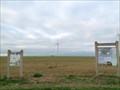
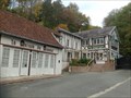
|  Parc Eolien du Magremont - Naours, Somme, France Parc Eolien du Magremont - Naours, Somme, France
in Windmills Départementale route D117 posted by: elyob location: Hauts-de-France, France date approved: 11/18/2016 last visited: never |
 view gallery view gallery S12.2 km S12.2 km
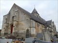
|  Eglise cimetière de Naours, Naours, Somme, France Eglise cimetière de Naours, Naours, Somme, France
in Worldwide Cemeteries rue de Fossé de l'Église posted by: elyob location: Hauts-de-France, France date approved: 11/05/2016 last visited: never |
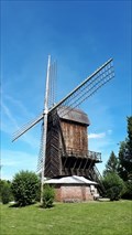 view gallery view galleryS12.4 km | Moulin du Belcan - Naours, France in Windmills [FR] Le moulin du Belcan était un moulin à huile qui existait avant la Révolution française. [EN] The Belcan windmill produced oil and dates before the French Revovlution. posted by: RakeInTheCache location: Hauts-de-France, France date approved: 07/19/2020 last visited: never |
 view gallery view galleryS12.6 km |  La Cité Souterraine de Naours - Naours, France La Cité Souterraine de Naours - Naours, France
in Official Local Tourism Attractions [FR] La cité souterraine de Naours est un ancien habitat souterrain développant plus de 2 000 mètres de galeries. [EN] It is literally an ancient underground city whose entrance was "closed" and was restored by the parish priest in 1887. posted by: RakeInTheCache location: Hauts-de-France, France date approved: 08/07/2020 last visited: never |
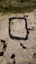 view gallery view galleryS12.6 km |  La Cité Souterraine de Naours - Naours, France La Cité Souterraine de Naours - Naours, France
in Paleontology and Fossils [FR] La cité souterraine est creusée dans la craie du Crétacé supérieur, riche en fossiles d'oursins, de bivalves et d'ammonites. [EN] The underground city is dug into Upper Cretaceouse limestone rich in urchins, bi-valves and ammonites. posted by: RakeInTheCache location: Hauts-de-France, France date approved: 08/08/2020 last visited: never |
 view gallery view galleryS12.6 km | ") Cité souterraine de Naours, Somme, France Cité souterraine de Naours, Somme, France
in Cave Entrances (Artificial) 5 Rue des Carrières, 80260 Naours posted by: elyob location: Hauts-de-France, France date approved: 12/19/2016 last visited: 07/12/2020 |
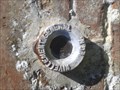 view gallery view gallery NW12.6 km NW12.6 km
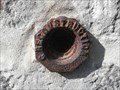
|  Benchmark - Eglise St Jean-Baptiste de Hiermont Benchmark - Eglise St Jean-Baptiste de Hiermont
in French Benchmarks Repère Cylindrique du Nivellement Général posted by: pmaupin location: Hauts-de-France, France date approved: 06/07/2015 last visited: 06/04/2015 |
 view gallery view gallery NE14.2 km NE14.2 km
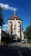
| Belfries of Belgium and France - Beffroi de porte de Lucheux, France, ID=943-053 in World Heritage Sites [FR]Le Beffroi de Lucheux fut construit sur une ancienne porte du bourg. [EN] Belfries are the symbol of freedom in cities. The Belfry of Lucheux was built on top of an old gate of the town. posted by: RakeInTheCache location: Hauts-de-France, France date approved: 07/19/2020 last visited: never |
 view gallery view gallery N15 km N15 km
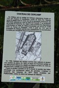
| ") Château de Cercamp - Frévent, France Château de Cercamp - Frévent, France
in Histoires de France (French historical markers) [FR] Situé sur la rive gauche de la Canche, ce château et son pavillon d'entrée en fer à cheval sont les vestiges d'un célèbre monastère cistercien fondé en 1137.
[EN] Located on the left bank of the Canche, this castle and its horseshoe entrance pavilion are the remains of a famous Cistercian monastery founded in 1137 posted by: pmaupin location: Hauts-de-France, France date approved: 04/24/2019 last visited: 04/18/2019 |
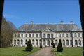
 view gallery view galleryN15 km |  Ancienne Abbaye Notre-Dame de Cercamp - Frévent, France Ancienne Abbaye Notre-Dame de Cercamp - Frévent, France
in Wikipedia Entries [EN] A Cistercian abbey was founded in the wooded site of Cercamp, in Frevent, in 1141, by the count of Saint-Pol, thanks to the monks of Pontigny.
[FR] Une abbaye cistercienne fut fondée dans le site boisé de Cercamp, à Frévent, en 1141, par le comte de Saint-Pol, grâce aux moines de Pontigny. posted by: pmaupin location: Hauts-de-France, France date approved: 04/24/2019 last visited: 04/18/2019 |
 view gallery view galleryN15 km |  Château de Cercamp - Frévent, France Château de Cercamp - Frévent, France
in Castles [EN] Located on the left bank of the Canche, this castle and its horseshoe entrance pavilion are the remains of a famous Cistercian monastery founded in 1137
[FR] Situé sur la rive gauche de la Canche, ce château et son pavillon d'entrée en fer à cheval sont les vestiges d'un célèbre monastère cistercien fondé en 1137. posted by: pmaupin location: Hauts-de-France, France date approved: 04/24/2019 last visited: 04/18/2019 |
 view gallery view galleryN15 km |  Ancienne Abbaye Notre-Dame de Cercamp - Frévent, France Ancienne Abbaye Notre-Dame de Cercamp - Frévent, France
in Monuments Historiques Français [FR] Une abbaye cistercienne fut fondée dans le site boisé de Cercamp, à Frévent, en 1141, par le comte de Saint-Pol, grâce aux moines de Pontigny.
[EN] A Cistercian abbey was founded in the wooded site of Cercamp, in Frevent, in 1141, by the count of Saint-Pol, thanks to the monks of Pontigny. posted by: pmaupin location: Hauts-de-France, France date approved: 04/24/2019 last visited: 04/18/2019 |
 view gallery view galleryN15 km |  Ancienne Abbaye Notre-Dame de Cercamp - Frévent, France Ancienne Abbaye Notre-Dame de Cercamp - Frévent, France
in Abbeys, Convents and Monasteries [EN] A Cistercian abbey was founded in the wooded site of Cercamp, in Frevent, in 1141, by the count of Saint-Pol, thanks to the monks of Pontigny. [FR] Une abbaye cistercienne fut fondée dans le site boisé de Cercamp, à Frévent, en 1141, par le comte de Saint-Pol, grâce aux moines de Pontigny. posted by: pmaupin location: Hauts-de-France, France date approved: 04/24/2019 last visited: 04/18/2019 |
 view gallery view gallery W15.1 km W15.1 km
|  La Traverse du Ponthieu - Cumont, France La Traverse du Ponthieu - Cumont, France
in Rails to Trails [EN] 18 km hike, on foot, by bike or on horseback. [FR] Randonnée de 18 km, à pieds, en vélo ou à cheval. posted by: pmaupin location: Hauts-de-France, France date approved: 04/21/2023 last visited: 04/21/2023 |
 view gallery view galleryW15.1 km |  La Traverse du Ponthieu - Cumont, France La Traverse du Ponthieu - Cumont, France
in Self Guided Walks and Trails [EN] 18 km hike, on foot, by bike or on horseback.
[FR] Randonnée de 18 km, à pieds, en vélo ou à cheval. posted by: pmaupin location: Hauts-de-France, France date approved: 04/22/2023 last visited: never |
 view gallery view galleryN15.4 km | Benchmark - 48 Rue de Doullens - Frévent, France in French Benchmarks Le Repère MRU (Ministère Reconstruction Urbanisme) se situe au N° 48, rue de Doullens à Frévent, à 50 m au sud du rond-point. posted by: pmaupin location: Hauts-de-France, France date approved: 04/23/2019 last visited: 04/23/2019 |
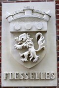 view gallery view galleryS15.6 km |  Le blason de pierre de la commune - Flesselles, France Le blason de pierre de la commune - Flesselles, France
in Coats of Arms Le blason, installé sur la façade de la mairie annexe située derrière l'église, a été sculpté en 1997 par A. PETIT. posted by: esslpt02100 location: Hauts-de-France, France date approved: 08/24/2018 last visited: never |
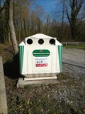
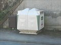 view gallery view galleryN15.6 km |  Do - Rue du Général de Gaulle - Frévent, France Do - Rue du Général de Gaulle - Frévent, France
in Places for Recycling [EN] Recycling point for glass. [FR] Point de recyclage pour le verre. posted by: pmaupin location: Hauts-de-France, France date approved: 04/25/2019 last visited: 04/18/2019 |
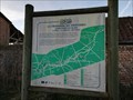
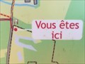 view gallery view galleryN15.6 km |  Vous Etes ici : Les Zones Humides - Ligny-sur-Canche, France Vous Etes ici : Les Zones Humides - Ligny-sur-Canche, France
in 'You Are Here' Maps [EN] The indications "you are here" is on an information board at the entrance of Ligny-sur-Canche, on a parking lot.
[FR] Les indications "vous êtes ici" se trouve sur un panneau d'information à l'entrée de Ligny-sur-Canche, sur un parking. posted by: pmaupin location: Hauts-de-France, France date approved: 04/25/2019 last visited: 04/18/2019 |
 view gallery view galleryN15.6 km | Do - Rue du Moulin - Ligny-sur-Canche, France in Places for Recycling [EN] Recycling point for glass. [FR] Point de recyclage pour le verre. posted by: pmaupin location: Hauts-de-France, France date approved: 04/25/2019 last visited: 04/18/2019 |
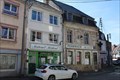 view gallery view galleryN15.8 km |  Pharmacie Normale - Frévent, France Pharmacie Normale - Frévent, France
in Independent Pharmacies [EN] Independent pharmacy located in downtown Frevent, place Jean-Jaurès.
[FR] Pharmacie indépendante située au centre ville de Frévent, place Jean-Jaurès. posted by: pmaupin location: Hauts-de-France, France date approved: 04/25/2019 last visited: 04/25/2019 |
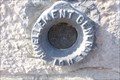 view gallery view galleryN15.8 km | Benchmark - Hôtel de Ville - Frévent, France in French Benchmarks Le Repère Cylindrique du Nivellement Général se situe sur le soubassement de la chaine d'angle ouest du mur de façade sur de la Mairie, face à la rue du Président Wilson. posted by: pmaupin location: Hauts-de-France, France date approved: 04/24/2019 last visited: 04/24/2019 |
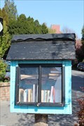 view gallery view galleryN15.8 km |  Cabanne à Livres - Frévent, France Cabanne à Livres - Frévent, France
in Free Community Book Exchanges [EN] A box reading where each of us the opportunity to drop off a book. [FR] Une boîte à lire où chacun de nous à la possibilité d'y déposer un livre. posted by: pmaupin location: Hauts-de-France, France date approved: 04/24/2019 last visited: 04/24/2019 |
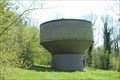 view gallery view galleryN15.8 km |  Château d'eau - Frévent, France Château d'eau - Frévent, France
in Water Towers [EN] A small water tower located on the heights of Frevent, near the cemetery.
[FR] Un petit château d'eau situé sur les hauteurs de Frévent, près du cimetière. posted by: pmaupin location: Hauts-de-France, France date approved: 04/29/2019 last visited: 04/18/2019 |
|