 view gallery view gallery S35.2 km S35.2 km
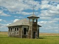
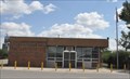
|   Burnham School - Burnham, MT Burnham School - Burnham, MT
in One-Room Schoolhouses Not quite abandoned but certainly not in use posted by:  Bon Echo Bon Echo location: Montana date approved: 12/07/2018 last visited: never |
 view gallery view gallery SE41.5 km SE41.5 km
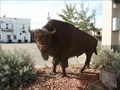
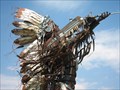
|  Buffalo in Havre, MT Buffalo in Havre, MT
in Figurative Public Sculpture This metal scuplture of a "Buffalo" is located in a park in Havre, MT along U. S. Hwy 2. No information is posted about the Buffalo. posted by:  The-DuHawks The-DuHawks location: Montana date approved: 09/17/2008 last visited: 05/26/2014 |
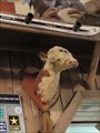 view gallery view gallerySE57.5 km |  Bar with Two-Headed Calf - Columbus, Montana: Bar with Two-Headed Calf - Columbus, Montana:
in Roadside Attractions This two-headed calf is in the New Atlas Bar located at 528 E. Pike Avenue in downtown Columbus. posted by: T0SHEA location: Montana date approved: 02/24/2018 last visited: never |
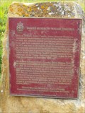
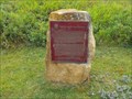
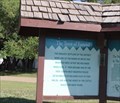
 view gallery view gallerySE60.7 km |  The Battle of Bears Paw - Chinook, MT The Battle of Bears Paw - Chinook, MT
in Montana Historical Markers Just west of Chinook, describes a battle that took place some 20 miles to the south posted by: Bon Echo location: Montana date approved: 07/23/2018 last visited: never |
 view gallery view galleryS63.1 km |  Rocky Boy's Reservation, Chippewa-Cree - Montana, USA Rocky Boy's Reservation, Chippewa-Cree - Montana, USA
in Nations Within Nations Chippewa-Cree - Tansi posted by: CerealBoxMonsters location: Montana date approved: 07/30/2009 last visited: never |
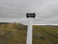
 view gallery view gallery SW63.6 km SW63.6 km
|  Inverness Web Camera - Inverness, MT Inverness Web Camera - Inverness, MT
in Web Cameras This is one of 73 (as of January 2017) Road Weather Information System camera sites operated by the Montana Department of Transportation to aid motorists as they make their way across BIG SKY Country. posted by: T0SHEA location: Montana date approved: 01/28/2017 last visited: never |
 view gallery view gallery NE70 km NE70 km
|  NWMP Trail Marker NWMP Trail Marker
in Saskatchewan Historical Markers Located on grid road access to Cypress Lake campground. posted by: Altima Voyageur location: Saskatchewan, Canada date approved: 09/25/2013 last visited: never |
 view gallery view gallery N74.5 km N74.5 km
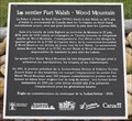
| Cypress Hills Massacre National Site, Le Massacre de Cypress Hills in Saskatchewan Historical Markers This is a short walk from Fort Walsh. A bus would normally take tourists to this site during the open season. Steep hills are involved to access this place. posted by: Altima Voyageur location: Saskatchewan, Canada date approved: 09/22/2013 last visited: never |
 view gallery view galleryN74.5 km |  CNHS Cypress Hills Massacre National Site, Le Massacre de Cypress Hills CNHS Cypress Hills Massacre National Site, Le Massacre de Cypress Hills
in Canadian National Historic Sites This is a short walk from Fort Walsh. A bus would normally take tourists to this site during the open season. Steep hills are involved to access this place. posted by: Altima Voyageur location: Saskatchewan, Canada date approved: 11/19/2017 last visited: never |
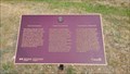
 view gallery view galleryN76.8 km | The Wood Mountain - Fort Walsh Trail in Saskatchewan Historical Markers Located near Fort Walsh posted by: Altima Voyageur location: Saskatchewan, Canada date approved: 09/22/2013 last visited: never |
 view gallery view galleryN76.8 km | Old Forts Trail, Fort Walsh-Fort Benton Trail in Saskatchewan Historical Markers Located near Fort Walsh. posted by: Altima Voyageur location: Saskatchewan, Canada date approved: 09/22/2013 last visited: never |
 view gallery view galleryN76.9 km | Establishment of the North West Mounted Police in Saskatchewan Historical Markers A beautiful statue. posted by: Altima Voyageur location: Saskatchewan, Canada date approved: 09/22/2013 last visited: never |
 view gallery view galleryN77.1 km | CNHP James Morrow Walsh 1840-1905 in Canadian National Historic Sites Located just outside Fort Walsh Museum building at Fort Walsh Historic Site. posted by: Altima Voyageur location: Saskatchewan, Canada date approved: 11/19/2017 last visited: never |
 view gallery view galleryN77.1 km | James Morrow Walsh 1840-1905, National Historic Monument in Saskatchewan Historical Markers Located just outside Fort Walsh Museum building. posted by: Altima Voyageur location: Saskatchewan, Canada date approved: 09/22/2013 last visited: never |
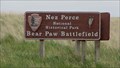 view gallery view gallerySE78.1 km | ") Nez Perce National Historical Park / Bear Paw Battlefield - Chinook, MT Nez Perce National Historical Park / Bear Paw Battlefield - Chinook, MT
in National Parks (U.S.) Located 15 miles south of Chinook, MT on Highway 240, the Bear Paw Battlefield commemorates the final battle of the Nez Perce War of 1877.
posted by: Martin 5 location: Montana date approved: 02/19/2009 last visited: never |
 view gallery view galleryS79.3 km |  Big Sandy, MT 59520 Big Sandy, MT 59520
in U.S. Post Offices This Post Office serves the town of Big Sandy and its surrounding community of approximately 1,000 people. posted by: CerealBoxMonsters location: Montana date approved: 10/26/2009 last visited: 05/22/2010 |
 view gallery view gallerySW85.6 km | Chester, Montana 59522 in U.S. Post Offices This Post Office is located at 25 Main Street in Chester, Montana. posted by: brwhiz location: Montana date approved: 01/30/2013 last visited: never |
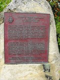
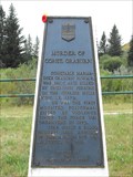 view gallery view galleryN86.7 km |  Murder of Constable Graburn Plaque, Detachment Site Marker Murder of Constable Graburn Plaque, Detachment Site Marker
in Alberta Heritage Markers The grave site if Constable Graburn and plaque describing posted by: Altima Voyageur location: Alberta, Canada date approved: 11/28/2017 last visited: 07/01/2022 |
 view gallery view gallerySE93.3 km | Ft. Belknap Reservation, Gros Ventre & Assiniboine - Montana, USA in Nations Within Nations Gros Ventre & Assiniboine - Nakoda posted by: CerealBoxMonsters location: Montana date approved: 07/30/2009 last visited: never |
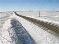
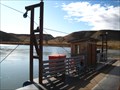 view gallery view galleryS100.6 km |  Virgelle Ferry - Virgelle, MT Virgelle Ferry - Virgelle, MT
in Ferries and Ferry Landings The Virgelle Ferry crossing has been operating since 1918, and is one of two state owned ferries along the Missouri River found in Montana. posted by: CerealBoxMonsters location: Montana date approved: 10/26/2009 last visited: 07/29/2015 |
 view gallery view galleryNE100.7 km | Crazy Horse Camp in Saskatchewan Historical Markers A few kilometers West of Eastend Saskatchewan. posted by: Altima Voyageur location: Saskatchewan, Canada date approved: 09/22/2013 last visited: never |
 view gallery view galleryNE106.2 km | Chocolate Peak -- Eastend SK CAN in Saskatchewan Historical Markers A Saskatchewan historical marker erected by the town of Eastend at the vista overlooking Chocolate Peak, formerly known as Wedding Cake Hill posted by: Benchmark Blasterz location: Saskatchewan, Canada date approved: 05/31/2023 last visited: 07/24/2019 |
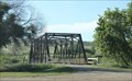 view gallery view galleryNE107.2 km |  Frenchman River Truss Bridge -- Eastend SK CAN Frenchman River Truss Bridge -- Eastend SK CAN
in Truss Bridges A handsome truss bridge over the Frenchmen River on the west side of Eastend. posted by: Benchmark Blasterz location: Saskatchewan, Canada date approved: 05/25/2023 last visited: 07/23/2019 |
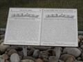
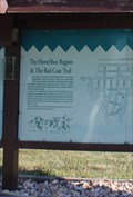 view gallery view galleryNE107.2 km | The HorseShoe Region & The Red Coat Trail -- Eastend SK CAN in Saskatchewan Historical Markers One of two Saskatchewan historical markers at a general visitor information kiosk on the west side of Eastend SK posted by: Benchmark Blasterz location: Saskatchewan, Canada date approved: 05/31/2023 last visited: 07/24/2019 |
 view gallery view galleryNE107.2 km | Town of Eastend -- Eastend SK CAN in Saskatchewan Historical Markers Second of two Saskatchewan historical markers at a general visitor information kiosk on the west side of Eastend SK posted by: Benchmark Blasterz location: Saskatchewan, Canada date approved: 05/31/2023 last visited: 07/24/2019 |
|