 view gallery view gallery SE4.2 km SE4.2 km
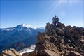
|   South Twin Sister - North Cascades, WA South Twin Sister - North Cascades, WA
in Mountain Summits A really fun scramble over a lot of what is largely dunite or olivine rock. posted by:  lahontan lahontan location: Washington date approved: 09/01/2022 last visited: never |
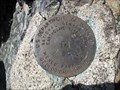
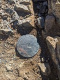 view gallery view gallerySE4.2 km |  SISTERS (TQ0669) - Whatcom Co., WA SISTERS (TQ0669) - Whatcom Co., WA
in U.S. Benchmarks Benchmark at summit of South Twin Sister posted by: lahontan location: Washington date approved: 08/07/2022 last visited: never |
 view gallery view gallery NW7.2 km NW7.2 km
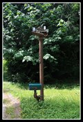
|  Homespun Kinetic Art — Welcome, WA Homespun Kinetic Art — Welcome, WA
in Kinetic Sculpture and Art In the foothills of the Northern Cascade Mountains is this whimsical kinetic sculpture. posted by:  Dunbar Loop Dunbar Loop location: Washington date approved: 07/17/2016 last visited: never |
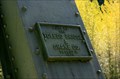 view gallery view galleryNW8.9 km |  Mosquito Lake Road Bridge - 1915 - Whatcom County, WA Mosquito Lake Road Bridge - 1915 - Whatcom County, WA
in Bridge Date Stones and Plaques The Mosquito Lake Road Bridge, AKA Middle Fork Nooksack River Bridge, is the longest pin-connected highway bridge in Washington and a rare example of a modified Pennsylvania Petit truss. posted by: Dunbar Loop location: Washington date approved: 06/11/2013 last visited: never |
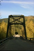 view gallery view galleryNW8.9 km |  Mosquito Lake Road Bridge — Whatcom County, WA Mosquito Lake Road Bridge — Whatcom County, WA
in Relocated Structures Originally located downriver, this 1915-built Pennsylvania Petit truss bridge was moved to Mosquito Lake Road in 1951. Today it continues to serve about 300 to 500 vehicles per day. posted by: Dunbar Loop location: Washington date approved: 06/08/2013 last visited: never |
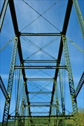 view gallery view galleryNW8.9 km |  Mosquito Lake Road Bridge — Whatcom County, WA Mosquito Lake Road Bridge — Whatcom County, WA
in Truss Bridges The Mosquito Lake Road Bridge, AKA Middle Fork Nooksack River Bridge, is the longest pin-connected highway bridge in Washington and a rare example of a modified Pennsylvania Petit truss. posted by: Dunbar Loop location: Washington date approved: 06/08/2013 last visited: never |
 view gallery view gallery N12.6 km N12.6 km
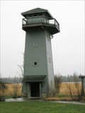
|  Tenant Lake Lookout Tower Tenant Lake Lookout Tower
in Look-Out Towers Tenant Lake Lookout Tower is located in the Fragrance Garden at Hovander Park in Ferndale Washington. posted by: Harriet the Spy location: Washington date approved: 02/11/2008 last visited: never |
 view gallery view gallery E13.4 km E13.4 km
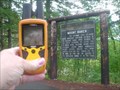
| PARK BUTTE REFERENCE in U.S. Benchmarks A USDIGS MONUMENT SET AT THE PARK BUTTE LOOKOUT. posted by: stevebratz location: Washington date approved: 09/01/2010 last visited: never |
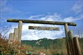 view gallery view galleryNW13.4 km |  Josh Vanderyacht Memorial Park Arch — Van Zandt, WA Josh Vanderyacht Memorial Park Arch — Van Zandt, WA
in Freestanding Arches This wooden arch greets people to the Josh Vanderyacht Memorial Park. posted by: Dunbar Loop location: Washington date approved: 04/09/2012 last visited: never |
 view gallery view galleryNW13.5 km |  Van Zandt Free Library — Van Zandt, WA Van Zandt Free Library — Van Zandt, WA
in Free Community Book Exchanges Located outside of Everybody's Store is the Van Zandt Free Library. posted by: Dunbar Loop location: Washington date approved: 07/02/2015 last visited: never |
 view gallery view gallery NE13.7 km NE13.7 km
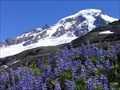
|  Mt. Baker, Heliotrope Trail, Glacier, WA Mt. Baker, Heliotrope Trail, Glacier, WA
in Scenic Hikes The Heliotrope Trail is one of the most scenic hikes on Mt Baker. This hike offers easy access to the trailhead and a varied walk bringing you to the Coleman Glacier and the climbers alpine route to the summit. posted by: arby101ca location: Washington date approved: 09/08/2010 last visited: 02/21/2022 |
 view gallery view gallery W14.5 km W14.5 km
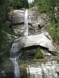
|  Hard Scrabble Falls Hard Scrabble Falls
in Waterfalls Spectacular 280 foot tall tiered waterfall posted by: Prying Pandora location: Washington date approved: 05/13/2009 last visited: 11/21/2013 |
 view gallery view galleryNW15.3 km | State Route 9, Bridge 315 — Deming, WA in Truss Bridges Spanning the North Fork of the Nooksack River this 1951 highway bridge is actually two truss bridges meeting on a pier in mid-river. posted by: Dunbar Loop location: Washington date approved: 04/09/2012 last visited: never |
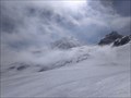
 view gallery view galleryE15.4 km |  Deming Glacier - Mount Baker Deming Glacier - Mount Baker
in Glaciers Deming Glacier on Mt. Baker posted by: E4han location: Washington date approved: 08/24/2008 last visited: 08/12/2020 |
 view gallery view galleryNW17.2 km |  Whatcom County Library System - Deming Public Library — Deming, WA Whatcom County Library System - Deming Public Library — Deming, WA
in Libraries This fairly new branch of the Whatcom County Library System serves the Deming community. posted by: Dunbar Loop location: Washington date approved: 04/09/2012 last visited: 11/21/2013 |
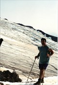
 view gallery view galleryE17.4 km | Mt. Baker - North Cascades, WA in Mountain Summits With good weather this is a great climb and the views are of course like few other. posted by: lahontan location: Washington date approved: 09/01/2022 last visited: never |
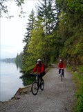 view gallery view galleryW19.8 km |  Hertz Trail — Bellingham, WA Hertz Trail — Bellingham, WA
in Rails to Trails Running along the shore of Lake Whatcom, the Hertz Trail is among the most scenic rails-to-trails in the area. posted by: Dunbar Loop location: Washington date approved: 01/30/2012 last visited: 01/11/2022 |
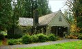 view gallery view galleryN19.8 km |  Glacier Ranger Station — Glacier, WA Glacier Ranger Station — Glacier, WA
in American Guide Series Built by the Civilian Conservation Corps the Glacier Ranger Station remains in use by the US Forest Service providing information to visitors to the Mt Baker-Snoqualmie National Forest. posted by: Dunbar Loop location: Washington date approved: 11/02/2010 last visited: 07/01/2012 |
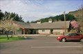
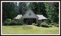 view gallery view galleryN19.8 km |  Glacier Public Service Center — Glacier, WA Glacier Public Service Center — Glacier, WA
in Ranger Stations The North Cascades is a rugged and wild place that is popular with hikers and campers. The Glacier Public Service Center has rangers to provide you the latest information for thMt. Baker-Snoqualmie National Forest and North Cascades National Park. posted by: Dunbar Loop location: Washington date approved: 06/25/2015 last visited: never |
 view gallery view galleryN19.8 km |  Glacier Ranger Station — Glacier, WA Glacier Ranger Station — Glacier, WA
in Civilian Conservation Corps Finished in 1938 by the Civilian Conservation Corps the Glacier Ranger Station remains in use by the US Forest Service providing information to visitors to the Mt Baker-Snoqualmie National Forest. posted by: Dunbar Loop location: Washington date approved: 11/01/2010 last visited: never |
 view gallery view galleryN19.8 km |  Smokey Bear — Glacier, WA Smokey Bear — Glacier, WA
in Smokey Bear Sign Sightings Heading up the Mount Baker Highway into the national forest and Smokey is there to tell you about the current fire level. posted by: Dunbar Loop location: Washington date approved: 07/01/2015 last visited: never |
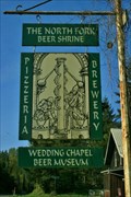 view gallery view galleryNW20.4 km |  The North Fork Brewery | pizzeria, beer shrine, wedding chapel, and microbrewery — Kendall, WA The North Fork Brewery | pizzeria, beer shrine, wedding chapel, and microbrewery — Kendall, WA
in Humorous Combination Businesses Microbrewery and pizzeria - a great combination. Beer shrine is a logical extension. Wedding chapel??? posted by: Dunbar Loop location: Washington date approved: 05/06/2013 last visited: never |
 view gallery view galleryNW20.8 km |  George Bonney (1871 - 1906) — Kendall, WA George Bonney (1871 - 1906) — Kendall, WA
in Woodmen of the World Grave Markers/Monuments Kendall got its start as a logging operation on the Bellingham Bay and British Columbia Railway. A member of this community, and part of the Woodmen, was George Bonney. posted by: Dunbar Loop location: Washington date approved: 06/08/2015 last visited: never |
 view gallery view galleryNE21.7 km | Mt Baker Skyline Divide Trail, Glacier WA in Scenic Hikes One of the most popular scenic hikes on Mt Baker is the Skyline Divide Trail. This trail is along an open ridge heading up towards of the summit on the north side of Mt Baker. posted by: arby101ca location: Washington date approved: 10/11/2010 last visited: never |
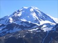
 view gallery view galleryN22 km |  Mt. Baker Mt. Baker
in Washington Historical Markers The present-day cone of Mount Baker is relatively young, perhaps less than 30,000 years old, but it sits atop a similar older volcanic cone called Black Buttes Volcano which was active between 500,000 and 300,000 years ago. posted by: SeabeckTribe location: Washington date approved: 04/05/2008 last visited: 09/15/2013 |
|