 view gallery view gallery S7.7 km S7.7 km
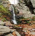
|   Starohutský waterfall - Pohronský Inovec, Slovakia Starohutský waterfall - Pohronský Inovec, Slovakia
in Waterfalls 5 metres high waterfall in central Slovakia, created after the tectonic depression of Sklený creek valley, which became separated from the Jakešova rock in the Cenozoic andezites. posted by:  Rikitan Rikitan location: Banskobystrický kraj, Slovakia date approved: 11/03/2013 last visited: 12/18/2017 |
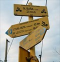
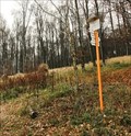 view gallery view galleryS8.9 km |  Loksova luka - Pohronsky Inovec, Slovakia Loksova luka - Pohronsky Inovec, Slovakia
in Direction and Distance Arrows Hiking signage post with 4 direction & distance slats, installed on border of big meadow in Pohronsky Inovec mountains, central Slovakia. posted by: Rikitan location: Banskobystrický kraj, Slovakia date approved: 11/03/2013 last visited: 12/18/2017 |
 view gallery view gallery SE8.9 km SE8.9 km
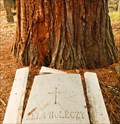
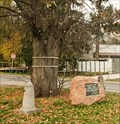
|  Sekvoja Holeczy - Nova Bana, Slovakia Sekvoja Holeczy - Nova Bana, Slovakia
in Sequoioideae Trees Sequoiadendron giganteum in Nova Bana - one of several such trees in the town. Not the highest, nor oldest one, but special by its story. It was dedicated to Zela Holeczy from her husband Peter. After she passed away ... posted by: Rikitan location: Banskobystrický kraj, Slovakia date approved: 11/03/2013 last visited: 07/15/2015 |
 view gallery view galleryS9.3 km |  Go hide yourself in ... Go hide yourself in ...
in Photo Goals ... in leaves, snow, sand, hay, grain, or even in bank notes if you wish! Use your creativity, lay down to any solid material and cover yourself completely apart from your face. posted by: Rikitan location: Banskobystrický kraj, Slovakia date approved: 11/07/2013 last visited: 02/17/2023 |
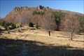
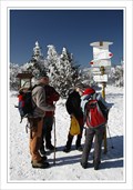
 view gallery view galleryS9.8 km |  Velky Inovec - Pohronsky Inovec, Slovakia Velky Inovec - Pohronsky Inovec, Slovakia
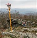
in Summit Registers Summit register on the top of Velky Inovec hill is installed in rocky cavity, covered by metal door.
Velky Inovec (901 metres / 2956 feet ASL) is highest hill of volcanic mountains called Pohronsky Inovec in central Slovakia. posted by: Rikitan location: Nitriansky kraj, Slovakia date approved: 11/03/2013 last visited: 05/19/2015 |
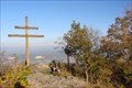
 view gallery view galleryS9.8 km | Velky Inovec, summit - Pohronsky Inovec, Slovakia in Direction and Distance Arrows Hiking signage post with 2 direction & distance slats, installed on the top of Velky Inovec mountain, central Slovakia. posted by: Rikitan location: Banskobystrický kraj, Slovakia date approved: 11/03/2013 last visited: 12/18/2017 |
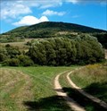 view gallery view galleryS9.8 km |  Velky Inovec - Pohronsky Inovec, Slovakia Velky Inovec - Pohronsky Inovec, Slovakia
in Mountain Summits Velky Inovec (901 metres / 2956 feet ASL) is highest hill of volcanic mountains called Pohronsky Inovec in central Slovakia. posted by: Rikitan location: Banskobystrický kraj, Slovakia date approved: 11/03/2013 last visited: 12/18/2017 |
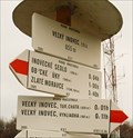 view gallery view galleryS9.8 km | Velky Inovec, luka - Pohronsky Inovec, Slovakia in Direction and Distance Arrows Hiking signage post with 6 direction & distance slats, installed on great meadow under summit of Velky Inovec, central Slovakia. posted by: Rikitan location: Banskobystrický kraj, Slovakia date approved: 11/03/2013 last visited: 11/09/2013 |
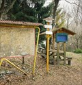 view gallery view galleryS9.8 km | Velky Inovec, challet - Pohronsky Inovec, Slovakia in Direction and Distance Arrows Hiking and Cycling signage post with 5 direction & distance slats, installed in front of a cottage under summit of Velky Inovec, central Slovakia. posted by: Rikitan location: Banskobystrický kraj, Slovakia date approved: 11/03/2013 last visited: 11/09/2013 |
 view gallery view gallerySE10 km |  Dodekova lipa (linden) - Nova Bana, Slovakia Dodekova lipa (linden) - Nova Bana, Slovakia
in Dedicated Trees Linden tree in small slovak town Nova Bana is dedicated to first city mayor Karol Dodek (1867 - 1922). Tree is located in downtown, next to main street in front of Lidl store. posted by: Rikitan location: Banskobystrický kraj, Slovakia date approved: 11/05/2013 last visited: never |
 view gallery view gallerySE10 km | CYCLO M-5155C Nova Bana, Lidl - Slovakia in Direction and Distance Arrows Cycling signage post with 4 direction & distance slats, located in front of Lidl store in Nova Bana, central Slovakia. posted by: Rikitan location: Banskobystrický kraj, Slovakia date approved: 11/03/2013 last visited: never |
 view gallery view gallery N12.6 km N12.6 km
| Buchlov in Mountain Summits Mountain (1041m) in southern part of Vtacnik mountains, above Hornonitrianska basin, not far from city of Partizanske and Zarnovica. posted by: Rikitan location: Trenčiansky kraj, Slovakia date approved: 12/27/2007 last visited: 10/30/2010 |
 view gallery view galleryN12.7 km | Zarnov in Mountain Summits Markable hill(840m) in southern part of Vtacnik mountains, right above Hornonitrianska basin, not far from city of Partizanske. posted by: Rikitan location: Trenčiansky kraj, Slovakia date approved: 10/29/2007 last visited: 06/06/2021 |
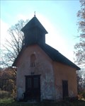 view gallery view gallery NW13.2 km NW13.2 km
|  St. John Nepomucene chapel at Vrchhora St. John Nepomucene chapel at Vrchhora
in Waychapels 18th century baroque style chapel in Tribec hills. posted by: haggaeus location: Trenčiansky kraj, Slovakia date approved: 11/07/2007 last visited: 12/26/2014 |
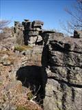 view gallery view galleryN13.8 km | Klastorska skala in Mountain Summits Klastorska skala (1279m) on a main crest of Vtacnik mountains in central part of Slovakia is a group of rocky boles, towering high above woody surroundings. posted by: Rikitan location: Trenčiansky kraj, Slovakia date approved: 12/27/2007 last visited: 02/08/2011 |
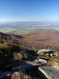 view gallery view galleryN15.1 km | Vtacnik (1346m) in Mountain Summits The highest summit of Vtacnik mountains in central part of Slovakia. posted by: Rikitan location: Trenčiansky kraj, Slovakia date approved: 12/27/2007 last visited: 02/08/2011 |
 view gallery view galleryN15.1 km | Vtacnik (1346m) - Vtacnik Mts, Slovakia in Summit Registers Summit register on top of the Vtacnik hill (1,346m / 4,416ft), the highest peak in volcanic Vtacnik mountains in central Slovakia. posted by: Rikitan location: Trenčiansky kraj, Slovakia date approved: 03/03/2011 last visited: 04/11/2009 |
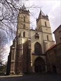 view gallery view galleryS16.9 km |  Monastery of Benedicts - Hronsky Benadik, Slovakia Monastery of Benedicts - Hronsky Benadik, Slovakia
in Roman Catholic Churches [EN]Monastery of Benedicts consist of fortified sacred buildings in Hronsky Benadik village.
[SK]Benediktinsky klastor v Hronskom Benadiku tvori subor opevnenych sakralnych stavieb v obci Hronsky Benadik.
posted by: crowak location: Banskobystrický kraj, Slovakia date approved: 11/29/2009 last visited: 12/18/2017 |
 view gallery view gallery E22.4 km E22.4 km
|  Banská Štiavnica, technical and natural monuments Banská Štiavnica, technical and natural monuments
in World Heritage Sites Location: Banska Stiavnica - old historic town centre with monuments and sights around.
Country: Slovakia posted by: Rikitan location: Banskobystrický kraj, Slovakia date approved: 11/19/2005 last visited: 03/27/2015 |
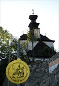
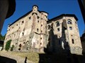 view gallery view galleryE24.1 km |  Starý zámok - Banska Stiavnica, SK Starý zámok - Banska Stiavnica, SK
in Castles The Old Castle, which is documented in 1486. posted by:  Noe1 Noe1 location: Banskobystrický kraj, Slovakia date approved: 03/28/2015 last visited: 12/18/2017 |
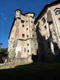 view gallery view galleryE24.3 km |  Mestský hrad v Banskej Štiavnici Mestský hrad v Banskej Štiavnici
in Wikipedia Entries The Old Castle, which is documented in 1486. posted by: Noe1 location: Banskobystrický kraj, Slovakia date approved: 03/27/2015 last visited: 12/18/2017 |
 view gallery view galleryE24.3 km |  No. 168, Mesto - Banská Štiavnica, SK No. 168, Mesto - Banská Štiavnica, SK
in Tourist Stamps Photos The first "tourist stamp" of Banska Stiavnica town. posted by: haggaeus location: Banskobystrický kraj, Slovakia date approved: 10/26/2011 last visited: 12/18/2017 |
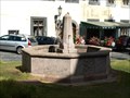 view gallery view galleryE24.3 km |  Kašna na Nám. svätej Trojice - Banská Štiavnica, SK Kašna na Nám. svätej Trojice - Banská Štiavnica, SK
in Fountains A small fountain on a beautiful square. posted by: Noe1 location: Banskobystrický kraj, Slovakia date approved: 03/26/2015 last visited: never |
 view gallery view galleryE24.3 km |  Banská Štiavnica Trinity Column Banská Štiavnica Trinity Column
in Baroque Architecture Plague column at the old town square. posted by: haggaeus location: Banskobystrický kraj, Slovakia date approved: 10/30/2011 last visited: 07/26/2023 |
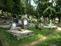 view gallery view galleryE24.5 km |  Evanjelický cintorín nad Klopackou - Bánská Štiavnica, SK Evanjelický cintorín nad Klopackou - Bánská Štiavnica, SK
in Worldwide Cemeteries The smaller of the historic cemetery on the outskirts of the historic city center. In this cemetery used to be buried townspeople of the Protestant faith. posted by: Noe1 location: Banskobystrický kraj, Slovakia date approved: 12/15/2013 last visited: never |
|