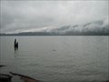
 view gallery view gallery NW14.2 km NW14.2 km
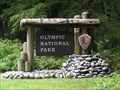
|  ") Olympic National Park - Washington Olympic National Park - Washington
in National Parks (U.S.) One of the prettiest places on planet earth! posted by:  Mooroid Mooroid location: Washington date approved: 05/15/2011 last visited: 04/17/2024 |
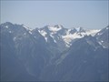 view gallery view galleryNW19 km |  Carrie Galcier Olympic National Park, WA, US Carrie Galcier Olympic National Park, WA, US
in Glaciers Carrie Galcier can been seen from Hurricane Ridge Vistor Center. It is reached by taking Hwy 101 into Port Angeles, then turning south on Race Street, and take a slight right curve on to the Hurricane Ridge Parkway. posted by:  Crazy4horses Crazy4horses location: Washington date approved: 11/23/2016 last visited: 07/12/2017 |
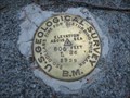
 view gallery view gallery NE24.8 km NE24.8 km
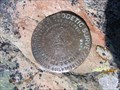
|  US Coastal and Geodetic Survey Triangulation Station, Elk Mtn, Olympic National Park, WA US Coastal and Geodetic Survey Triangulation Station, Elk Mtn, Olympic National Park, WA
in U.S. Benchmarks On the summit of Elk Mtn in Olympic national Park is a US Coastal and Geodetic Survey Triangulation Station, dated 1955. posted by: arby101ca location: Washington date approved: 08/02/2010 last visited: never |
 view gallery view gallery SW25.1 km SW25.1 km
| WSDOT Survey Monument BUNCH in U.S. Benchmarks Located east of Lake Quinault on bridge over Quinault River that connnects North Shore Road and South Shore Road posted by: sealawyer98 location: Washington date approved: 04/08/2011 last visited: 04/03/2011 |
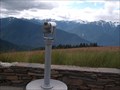 view gallery view gallery N26.1 km N26.1 km
|  Hurricane Ridge Visitor Center Binocular - Olympic National Park, Washington Hurricane Ridge Visitor Center Binocular - Olympic National Park, Washington
in Coin-Op Binoculars Come see Carrie Glacier! posted by: BarbershopDru location: Washington date approved: 09/25/2011 last visited: 08/18/2017 |
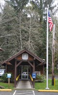
 view gallery view galleryN26.1 km |  Hurricane Ridge Visitor Center - Olympic National Park, Washington Hurricane Ridge Visitor Center - Olympic National Park, Washington
in Tourist Information Centers - Visitor Centers Come and hike The Ridge! posted by: BarbershopDru location: Washington date approved: 09/25/2011 last visited: 04/17/2024 |
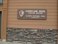 view gallery view galleryN26.1 km |  Hurricane Ridge Visitor Center - Olympic National Park, Washinton Hurricane Ridge Visitor Center - Olympic National Park, Washinton
in Elevation Signs The perfect National Park sign! posted by: BarbershopDru location: Washington date approved: 09/25/2011 last visited: 04/17/2024 |
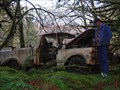 view gallery view gallerySW27.4 km |  Rust In Peace Rust In Peace
in Abandoned Dead Vehicles The Rainforest is reclaiming this truck near Lake Quinault. posted by: Seek&Find location: Washington date approved: 01/30/2007 last visited: never |
  SE28.2 km SE28.2 km
|  Wet & Wild 2 - Staircase Wet & Wild 2 - Staircase
in Swimming Holes This is an easy flat walk to the swimming hole, about .3 miles from parking area. Great for kids.
posted by: malachite location: Washington date approved: 08/28/2005 last visited: 09/08/2012 |
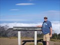 view gallery view galleryN28.3 km |  Hurricane Hill Hurricane Hill
in Mountain Summits A mountain top in Olympic National Park. posted by: Birdicus location: Washington date approved: 09/15/2009 last visited: 07/12/2017 |
 view gallery view galleryN30.1 km | US Geological Survey Marker, Elwha River Dam, Washington in U.S. Benchmarks An elevation bench mark near the Elwha River Dam in Olympic National Park in Washington state. posted by: DangerousDale location: Washington date approved: 09/17/2010 last visited: 09/17/2010 |
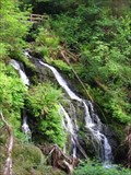
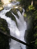 view gallery view galleryNW32 km |  Sol Duc Falls - Crescent, Washington Sol Duc Falls - Crescent, Washington
in Waterfalls Sol Duc Falls in Olympic National Park - Washington. Easily one of the most beautiful falls I've ever seen! posted by: Mooroid location: Washington date approved: 05/15/2011 last visited: 08/26/2019 |
 view gallery view gallerySW32.5 km | Merriman Falls in Waterfalls A gorgeous horsetail fall with small cascades just below the pool, along the road that follows the southern bank of the Quinault River. It is easily accessible from roadside turnouts on either side of the bridge. posted by: krazykatzen location: Washington date approved: 07/04/2008 last visited: 07/12/2017 |
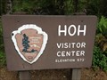 view gallery view galleryNW33.3 km | 573 Ft at Hoh Visitor Center - Olympic National Park in Elevation Signs The Hoh Visitor center sign states that you are at 573 ft above sea level. posted by: ChapterhouseInc location: Washington date approved: 07/07/2013 last visited: 07/12/2017 |
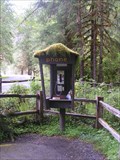 view gallery view galleryNW33.3 km |  Mossy Payphone - Hoh Rain Forest, Washington Mossy Payphone - Hoh Rain Forest, Washington
in Payphones Mossy Payphone - Hoh Rain Forest, Washington posted by: Mooroid location: Washington date approved: 05/15/2011 last visited: 02/10/2016 |
 view gallery view gallery E34.9 km E34.9 km
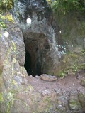
| ") Mine Wannabe - Tubal Cain / Tull Canyon Trail Junction Mine Wannabe - Tubal Cain / Tull Canyon Trail Junction
in Cave Entrances (Artificial) Exploratory dead-end mine shaft posted by: Prying Pandora location: Washington date approved: 08/20/2007 last visited: 07/29/2018 |
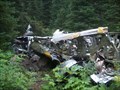 view gallery view galleryE35.4 km |  B-17 - Tull Canyon B-17 - Tull Canyon
in Plane Crash Sites B-17 Crash in the Olympic Mountains 20 miles South of Sequim, WA posted by: Prying Pandora location: Washington date approved: 12/11/2007 last visited: 07/17/2016 |
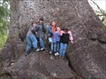 view gallery view gallerySW36.5 km |  World's Largest Sitka Spruce World's Largest Sitka Spruce
in Exceptional Trees World's Largest Sitka Spruce posted by: Vermontish location: Washington date approved: 06/20/2008 last visited: 08/18/2017 |
 view gallery view gallerySW36.7 km |  Lake Quinault - Olympic Peninsula, Washington Lake Quinault - Olympic Peninsula, Washington
in Wikipedia Entries Glacial lake posted by: Vermontish location: Washington date approved: 12/03/2009 last visited: 07/12/2017 |
 view gallery view gallerySW36.7 km |  Quinault, Washington 98575 Quinault, Washington 98575
in U.S. Post Offices This Post Office is located at 518 S Shore Road in Quinault, Washington. posted by: brwhiz location: Washington date approved: 12/01/2011 last visited: never |
 view gallery view gallerySW38.3 km |  Lake Quinault Lodge Penny Smasher Lake Quinault Lodge Penny Smasher
in Penny Smashers This four-design hand-cranked Penny Smasher is in the Lake Quinault Lodge at 345 S Shore Road in Quinault, Washington. posted by: brwhiz location: Washington date approved: 02/19/2012 last visited: never |
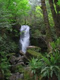
 view gallery view gallerySW38.3 km | Cascade Falls in Waterfalls A small, but photogenic falls a short hike from the Lake Quinault Lodge. During late summer, the creek might dry up to just a trickle and the cascades not be as scenic. posted by: krazykatzen location: Washington date approved: 07/04/2008 last visited: 03/10/2015 |
 view gallery view gallerySW39.4 km | Willaby Falls in Waterfalls A two-tiered falls along a clear creek, with a small canyon covered with ferns and mosses. Reaching the falls is a short (0.5 miles round trip) hike from the closest parking. posted by: krazykatzen location: Washington date approved: 07/04/2008 last visited: never |
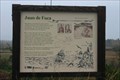 view gallery view galleryN40.4 km |  Juan De Fuca Juan De Fuca
in Washington Historical Markers This Historical Marker can be found near Laird's corner apx. five miles west of Port Angeles on Hwy 101 posted by: SeabeckTribe location: Washington date approved: 11/05/2006 last visited: 06/30/2010 |
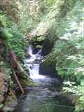
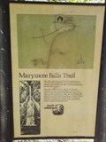 view gallery view galleryNW40.7 km |  Marymere Falls Trail - Olympic National Park, WA Marymere Falls Trail - Olympic National Park, WA
in Hiking and walking trailheads Marymere Falls is one of most popular family-friendly hikes on the Olympic Peninsula. posted by: RakeInTheCache location: Washington date approved: 05/25/2023 last visited: never |
|