 view gallery view gallery E0.6 km E0.6 km
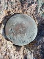
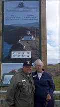
|   Crown Land Survey Disk #026 520 - Cape Spear, Newfoundland Crown Land Survey Disk #026 520 - Cape Spear, Newfoundland
in Canadian Benchmarks Newfoundland Crown Land Survey disk posted by:  Bon Echo Bon Echo location: Newfoundland and Labrador, Canada date approved: 05/02/2019 last visited: never |
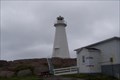 view gallery view galleryE0.8 km |  Cape Spear National Historic Site, Newfoundland, Canada Cape Spear National Historic Site, Newfoundland, Canada
in Coastal Lighthouses A lighthouse that began in the mid 1800's and was the second one in Newfoundland. Sits at the most easterly point in North America. posted by: Team Polarbear location: Newfoundland and Labrador, Canada date approved: 07/14/2007 last visited: 05/01/2021 |
 view gallery view gallery NE0.8 km NE0.8 km
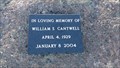
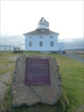
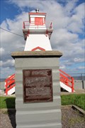
|  William S Cantwell - Cape Spear, Newfoundland William S Cantwell - Cape Spear, Newfoundland
in Citizen Memorials Memorial plaque to William S Cantwell of Cape Spear, by the Cape Spear Lighthouse National Historic Site. posted by:  SMacB SMacB location: Newfoundland and Labrador, Canada date approved: 03/13/2021 last visited: never |
 view gallery view galleryNE0.8 km | Benchmark - Reference Mark No. 1 - Cape Spear, Newfoundland and Labrador in Canadian Benchmarks The U.S. military had a presence at Cape Spear during WWII and installed this benchmark. Cape Spear was of strategic importance because it was a good location to protect St. John's Harbour. posted by: Trail Blaisers location: Newfoundland and Labrador, Canada date approved: 08/08/2015 last visited: 12/29/2017 |
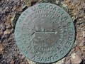
 view gallery view galleryNE0.8 km |  Cape Spear Reference Mark No. 1 - Newfoundland and Labrador Cape Spear Reference Mark No. 1 - Newfoundland and Labrador
in U.S. Benchmarks This is a second intact U.S. benchmark found at Cape Spear. posted by: Trail Blaisers location: Newfoundland and Labrador, Canada date approved: 07/19/2015 last visited: 06/08/2017 |
 view gallery view galleryNE0.8 km |  N 47 31.233 W 052 37.433 - Cape Speer, Newfoundland, CA N 47 31.233 W 052 37.433 - Cape Speer, Newfoundland, CA
in Permanent Geographic Coordinates Eastern most point in North America posted by: flyfishercacher location: Newfoundland and Labrador, Canada date approved: 02/26/2014 last visited: 08/23/2017 |
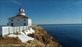
 view gallery view galleryNE0.8 km |  CNHS - Cape Spear Lighthouse - Cape Spear, Newfoundland and Labrador CNHS - Cape Spear Lighthouse - Cape Spear, Newfoundland and Labrador
in Canadian National Historic Sites Cape Spear Lighthouse was built in 1836 and is the oldest in Newfoundland and Labrador. It is on the most easterly point of land in North America and guided ships into St. John's Harbour for more than 100 years. posted by: Trail Blaisers location: Newfoundland and Labrador, Canada date approved: 01/07/2013 last visited: 05/01/2021 |
 view gallery view galleryNE0.8 km |  Cape Spear Lighthouse, Cape Spear, Newfoundland Cape Spear Lighthouse, Cape Spear, Newfoundland
in Atlantic Canada Heritage Properties At the most easterly point in North America, the Cape Spear lighthouse is a National Historic Site. posted by: Bon Echo location: Newfoundland and Labrador, Canada date approved: 04/12/2019 last visited: 06/04/2016 |
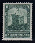
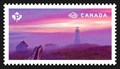 view gallery view galleryNE0.8 km |  Cape Spear Lighthouse, Newfoundland Cape Spear Lighthouse, Newfoundland
in Philatelic Photographs Though partially obscured by fog, the Cape Spear lighthouse can clearly be seen on this postage stamp issued in 2015. posted by: hykesj location: Newfoundland and Labrador, Canada date approved: 09/20/2017 last visited: 05/01/2021 |
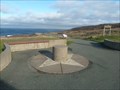 view gallery view galleryNE1 km |  Compass Rose - Cape Spear, Newfoundland and Labrador Compass Rose - Cape Spear, Newfoundland and Labrador
in Compass Roses A simple compass rose at Cape Spear Lighthouse National Historic Site. posted by: Trail Blaisers location: Newfoundland and Labrador, Canada date approved: 01/06/2013 last visited: 08/23/2017 |
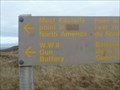
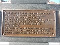
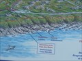 view gallery view galleryNE1 km |  You Are Here - Cape Spear, Newfoundland and Labrador You Are Here - Cape Spear, Newfoundland and Labrador
in 'You Are Here' Maps A map showing you the points of interest at Cape Spear Lighthouse National Historic Site. posted by: Trail Blaisers location: Newfoundland and Labrador, Canada date approved: 01/06/2013 last visited: 08/23/2017 |
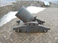
 view gallery view galleryNE1 km | Cape Spear - Reference Mark No.2 in U.S. Benchmarks Remnant of U.S. military presence at Cape Spear, Newfoundland, during World War II. posted by: wilsonjw location: Newfoundland and Labrador, Canada date approved: 11/23/2005 last visited: 03/15/2019 |
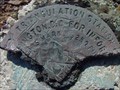 view gallery view galleryNE1 km | Cape Spear Triangulation Station 1942 in U.S. Benchmarks Remnant of U.S. military presence at Cape Spear, Newfoundland, during World War II. posted by: wilsonjw location: Newfoundland and Labrador, Canada date approved: 11/23/2005 last visited: 03/15/2019 |
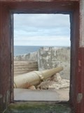 view gallery view galleryNE1.1 km |  "Disappearing" Guns - Fort Cape Spear, Newfoundland and Labrador "Disappearing" Guns - Fort Cape Spear, Newfoundland and Labrador
in Static Artillery Displays Two separate gun batteries holding 10" guns with disappearing carriages. posted by: Trail Blaisers location: Newfoundland and Labrador, Canada date approved: 02/26/2013 last visited: 03/15/2019 |
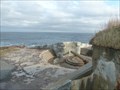 view gallery view galleryNE1.3 km |  Fort Cape Spear - Cape Spear, Newfoundland and Labrador Fort Cape Spear - Cape Spear, Newfoundland and Labrador
in Historic Forts Fort Cape Spear was built in 1940 by the Canadian and U.S. military to guard St. John's Harbour. posted by: Trail Blaisers location: Newfoundland and Labrador, Canada date approved: 01/29/2013 last visited: 05/01/2021 |
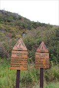
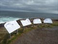 view gallery view galleryNE1.3 km |  Whales off of Cape Spear - Cape Spear, Newfoundland and Labrador Whales off of Cape Spear - Cape Spear, Newfoundland and Labrador
in Flora and Fauna Information Signs Cape Spear is an excellent place to spot whales and these four information boards will help you to identify them. posted by: Trail Blaisers location: Newfoundland and Labrador, Canada date approved: 01/06/2013 last visited: 07/28/2017 |
 view gallery view galleryNE1.3 km |  MOST EASTERLY - Point of land in North America - Cape Spear, Newfoundland and Labrador MOST EASTERLY - Point of land in North America - Cape Spear, Newfoundland and Labrador
in Superlatives Cape Spear is the most easterly point of land in North America. posted by: Trail Blaisers location: Newfoundland and Labrador, Canada date approved: 01/06/2013 last visited: 03/15/2019 |
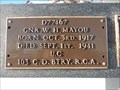 view gallery view galleryNE1.3 km | Gnr. W H Mayou - Cape Spear, Newfoundland in Citizen Memorials A memorial marker at the Eastern most point of mainland North America, Cape Spear, dedicated to those who have drowned at this location. This plaque is to Gnr. W H Mayou (d. Sept 1 1941). posted by: SMacB location: Newfoundland and Labrador, Canada date approved: 03/21/2021 last visited: never |
 view gallery view galleryNE1.3 km | Donald Wilfred Harvey Cook - Cape Spear, Newfoundland in Citizen Memorials A memorial marker at the Eastern most point of mainland North America, Cape Spear, dedicated to those who have drowned at this location. This plaque is to Donald Wilfred Harvey Cook (d. Sept. 4 1970) posted by: SMacB location: Newfoundland and Labrador, Canada date approved: 03/15/2021 last visited: never |
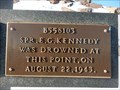 view gallery view galleryNE1.3 km | Spr. E G Kennedy - Cape Spear, Newfoundland in Citizen Memorials A memorial marker at the Eastern most point of mainland North America, Cape Spear, dedicated to those who have drowned at this location. This plaque is to Spr. E G Kennedy (d. Aug 22 1943). posted by: SMacB location: Newfoundland and Labrador, Canada date approved: 03/20/2021 last visited: never |
 view gallery view gallery W2.1 km W2.1 km
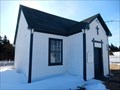
| St. Joseph’s Chapel, St. John's (Blackhead), Newfoundland in Atlantic Canada Heritage Properties Constructed in 1879, St. Joseph’s Chapel is both a City of St. John’s Heritage Structure and a City of St. John’s Heritage Site as well as a Registered Heritage Structure by the Heritage Foundation of Newfoundland and Labrador. posted by: Bon Echo location: Newfoundland and Labrador, Canada date approved: 04/12/2019 last visited: never |
 view gallery view gallery NW6.3 km NW6.3 km
| CNHS - Fort Amherst - St. John's, Newfoundland and Labrador in Canadian National Historic Sites Fort Amherst was designated a CNHS because the 1777 fortification guarded St. John’s harbour and was named after colonel William Amherst, who had recaptured St. John’s from the French in 1762. posted by: Trail Blaisers location: Newfoundland and Labrador, Canada date approved: 12/28/2013 last visited: 07/31/2017 |
 view gallery view galleryNW6.4 km |  East Coast Trail - Deadmans Bay Path, Newfoundland and Labrador East Coast Trail - Deadmans Bay Path, Newfoundland and Labrador
in Long Distance Hiking Trails A trailhead for the Deadmans Bay Path of the 265 km East Coast Trail that runs along the entire east coast of Newfoundland's rugged Avalon Peninsula. posted by: Trail Blaisers location: Newfoundland and Labrador, Canada date approved: 12/31/2013 last visited: 08/23/2017 |
 view gallery view galleryNW6.9 km | Signal Hill 32-pounder Muzzleloading Carronade - St John's, Newfoundland in Static Artillery Displays Cannonade on Signal Hill posted by: Bon Echo location: Newfoundland and Labrador, Canada date approved: 03/03/2021 last visited: never |
 view gallery view galleryNW6.9 km | Cabot Tower, St. John’s, NL in Philatelic Photographs This tower was built atop Signal Hill in St. John’s to commemorate the 400th anniversary of John Cabot’s 1497 voyage and also to commemorate Queen Victoria’s Diamond Jubilee year of reign. posted by: hykesj location: Newfoundland and Labrador, Canada date approved: 10/30/2017 last visited: 05/01/2021 |
|