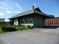
 view gallery view gallery SE0.2 km SE0.2 km
|   Fort Kent Railroad Station Fort Kent Railroad Station
in Wikipedia Entries The Fort Kent RR Station was listed in 1989. It is at the junction of Main and Market Streets in Fort Kent, ME posted by:  nomadwillie nomadwillie location: Maine date approved: 12/14/2009 last visited: 07/20/2009 |
 view gallery view gallerySE0.2 km |  Fort Kent Railroad Station - Fort Kent ME Fort Kent Railroad Station - Fort Kent ME
in U.S. National Register of Historic Places The Fort Kent RR Station was listed in 1989. It is at the junction of Main and Market Streets in Fort Kent, ME posted by: nomadwillie location: Maine date approved: 07/28/2009 last visited: 07/20/2009 |
 view gallery view gallerySE0.2 km |  Fort Kent Railroad Station - Fort Kent ME Fort Kent Railroad Station - Fort Kent ME
in Train Stations/Depots The Fort Kent RR Station was listed in 1989. It is at the junction of Main and Market Streets in Fort Kent, ME posted by: nomadwillie location: Maine date approved: 12/14/2009 last visited: 07/20/2009 |
 view gallery view gallery SW0.8 km SW0.8 km
| Fort Kent - Fort Kent ME in U.S. National Register of Historic Places Fort Kent is a site significant for its association with the Aroostook War.
It was declared a National Historic Landmark in 1973.
It is located about 0.75 miles southwest of the town of Fort Kent, Maine.
posted by: nomadwillie location: Maine date approved: 07/28/2009 last visited: 08/19/2012 |
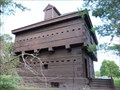 view gallery view gallerySW0.8 km |  Fort Kent - Fort Kent ME Fort Kent - Fort Kent ME
in Historic Forts Constructed 1838-1840, this is the only extant fortification of the Aroostook "War" (1838-1839), the conflict that climaxed the Northeast border disputes with Great Britain following the War of 1812. posted by: nomadwillie location: Maine date approved: 10/12/2009 last visited: 08/19/2012 |
 view gallery view gallerySW0.8 km | Fort Kent (fort) in Wikipedia Entries Fort Kent is a site significant for its association with the Aroostook War. It was declared a National Historic Landmark in 1973. It is located about 0.75 miles southwest of the town of Fort Kent, Maine.
posted by: nomadwillie location: Maine date approved: 12/14/2009 last visited: 08/19/2012 |
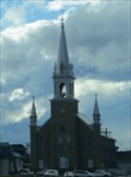
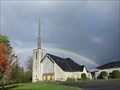 view gallery view gallerySW1 km |  Église - Saint-François-d’Assise - Church - Clair - Nouveau/New Brunswick Église - Saint-François-d’Assise - Church - Clair - Nouveau/New Brunswick
in Roman Catholic Churches Située sur la rue principale dans le village de Clair, l’église Saint-François-d’Assise se retrouve sur les rives du fleuve Saint-Jean. The church of Saint-François-d’Assise sits on the banks of the Saint-John River, in the village of Clair. posted by: Weathervane location: New Brunswick, Canada date approved: 03/01/2019 last visited: never |
 view gallery view gallery NE7.2 km NE7.2 km
|  400ième - Anniversaire de la Fondation de l'Acadie - 400th - Anniversary of the Foundation of Acadia, Baker Brook, Nouveau/New Brunswick 400ième - Anniversaire de la Fondation de l'Acadie - 400th - Anniversary of the Foundation of Acadia, Baker Brook, Nouveau/New Brunswick
in Community Commemoration La plaque du 400ième anniversaire de la fondation de l'Acadie est située en avant de l'église Saint-Cœur-de-Marie. The plaque of the 400th anniversary of the foundation of Acadia is located in front of the church of Saint-Coeur de Marie. posted by: Weathervane location: New Brunswick, Canada date approved: 03/01/2019 last visited: never |
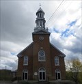
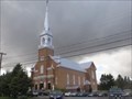 view gallery view galleryNE7.2 km | Église Saint-Coeur-de-Marie - Saint-Coeur-de-Marie Church - Baker Brook, Nouveau/New Brunswick in Roman Catholic Churches L’église Saint-Cœur-de-Marie est un édifice religieux en brique de style renouveau classique construite en 1927. Saint-Cœur-de-Marie Church is a brick religious building constructed in 1927 in the Classical Revival style. posted by: Weathervane location: New Brunswick, Canada date approved: 03/01/2019 last visited: never |
 view gallery view gallery W8.7 km W8.7 km
| Église de - Saint-François-Xavier - Church - Saint-François, Nouveau/New Brunswick in Roman Catholic Churches L'Église de Saint-François-Xavier, complétée en 1929, est située sur la rue Commerciale, à Saint-François. The Church of Saint-François-Xavier, completed in 1929, is located on Commerciale Street, in Saint-François. posted by: Weathervane location: New Brunswick, Canada date approved: 03/02/2019 last visited: never |
 view gallery view gallery E14.8 km E14.8 km
| Église de Saint-Hilaire - Saint-Hilaire Church - Saint-Hilaire, Nouveau/New-Brunswick in Roman Catholic Churches Construite en 1926 et située sur la rue Centrale, l’église de Saint-Hilaire est un édifice religieux moderne de style néoclassique. Built in 1926 and located on Centrale Street, the church of Saint-Hilaire is a modern neoclassical religious building. posted by: Weathervane location: New Brunswick, Canada date approved: 03/01/2019 last visited: never |
 view gallery view galleryE15.4 km | Frenchville Railroad Station and Water Tank - Frenchville ME in U.S. National Register of Historic Places The Caboose and Water Tank are on RT 1 in Frenchville. They were listed in 1995. posted by: nomadwillie location: Maine date approved: 07/28/2009 last visited: 07/10/2011 |
 view gallery view gallery NW18.2 km NW18.2 km
| ") Pont Romain-Caron - Saint-Jean-de-la-Lande, Québec Pont Romain-Caron - Saint-Jean-de-la-Lande, Québec
in Histoire du Quebec (Quebec Historical Markers) Le pont couvert Romain-Caron, construit en 1940, est situé sur la route du Lac-Baker à l'intersection du sixième rang, enjambant le petit ruisseau Baker. posted by: Weathervane location: Québec, Canada date approved: 09/08/2014 last visited: never |
 view gallery view galleryNE22 km |  McDonald's - Madawaska ME McDonald's - Madawaska ME
in McDonald's Restaurants This restaurant is near the intersection of Mill and Main streets. posted by: elyob location: Maine date approved: 04/08/2012 last visited: 04/09/2012 |
 view gallery view galleryNE22.2 km |  Shrine to Long Distance Bikers - Madawaska ME Shrine to Long Distance Bikers - Madawaska ME
in Roadside Attractions Located on RT 1 in Madawaska, it is also known as the the Madawaska Four Corners Park posted by: nomadwillie location: Maine date approved: 01/10/2018 last visited: never |
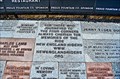 view gallery view galleryNE22.2 km |  Madawaska Four Corners Park - ME Madawaska Four Corners Park - ME
in Donated Engraved Bricks and Pavers Well known to the motorcycle community, it is the first park in the US dedicated to long distance riding. posted by: nomadwillie location: Maine date approved: 06/27/2013 last visited: 08/14/2021 |
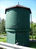
 view gallery view galleryNE22.5 km |  EDMUNSTON LARGE STANDPIPE EDMUNSTON LARGE STANDPIPE
in Water Towers a huge standpipe posted by:  cloudyboy cloudyboy location: New Brunswick, Canada date approved: 02/01/2008 last visited: 10/22/2017 |
 view gallery view galleryNE22.7 km |  Cathédrale de l'Immaculée-Conception - Cathedral of the Immaculate Conception - Edmundston, N.B. Cathédrale de l'Immaculée-Conception - Cathedral of the Immaculate Conception - Edmundston, N.B.
in Atlantic Canada Heritage Properties Construit entre 1925 et 1927, elle a servit d'abord d'église paroissiale et ensuite en 1944 elle est devenue cathédrale. Built between 1925 and 1927, it first served as a parish church and then as a cathedral. posted by: Weathervane location: New Brunswick, Canada date approved: 04/25/2021 last visited: never |
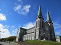 view gallery view galleryNE22.7 km | Cathédrale de l'Immaculée-Conception - Immaculate Conception Cathedral - Edmundston, NB in Roman Catholic Churches La Cathédrale de l'Immaculée-Conception fut construite en 1927 suite à des demarches entreprises par l'abbé William J. Conway. The Immaculate Conception Cathedral was built in 1927 following steps taken by father William J. Conway. posted by: Weathervane location: New Brunswick, Canada date approved: 12/19/2013 last visited: 10/22/2017 |
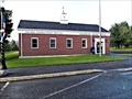 view gallery view galleryNE22.7 km |  Madawaska, ME 04756 Madawaska, ME 04756
in U.S. Post Offices Located at 370 E Main St, Madawaska ME posted by: nomadwillie location: Maine date approved: 06/21/2013 last visited: never |
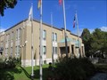 view gallery view galleryNE22.9 km |  Edmundston, NB Edmundston, NB
in City and Town Halls L'hôtel de ville d'Edmundston, contruit en 1948, est situé sur le chemin Canada, à Edmundston. Edmundston City Hall, built in 1948, is located on Canada Road, in Edmundston. posted by: Weathervane location: New Brunswick, Canada date approved: 12/20/2013 last visited: 10/22/2017 |
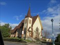 view gallery view galleryNE23 km |  Église anglicane Saint John the Baptist - St.John the Baptist Anglican Church - Edmundston, NB Église anglicane Saint John the Baptist - St.John the Baptist Anglican Church - Edmundston, NB
in Anglican and Episcopal Churches Consacrée en 1887, l’église anglicane St. John the Baptist est la plus ancienne église de la ville d'Edmundston. Consecrated in 1887, St. John the Baptist Anglican Church is the oldest surviving church in the city of Edmundston. posted by: Weathervane location: New Brunswick, Canada date approved: 12/20/2013 last visited: 04/27/2014 |
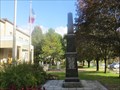 view gallery view galleryNE23 km |  Cénotaphe d'Edmundston - Edmundston Cenotaph - Edmundston, NB Cénotaphe d'Edmundston - Edmundston Cenotaph - Edmundston, NB
in Non-Specific Veteran Memorials Le cénotaphe d’Edmundston est un monument de granit noir en forme d’obélisque érigé en 1950 par la ville d’Edmundston. The Edmundston cenotaph is a black granite monument in the shape of an obelisk erected by the City of Edmundston in 1950. posted by: Weathervane location: New Brunswick, Canada date approved: 12/19/2013 last visited: 10/22/2017 |
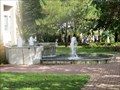 view gallery view galleryNE23 km |  Fontaine de l'Hôtel de Ville - City Hall Fountain - Edmundston, NB Fontaine de l'Hôtel de Ville - City Hall Fountain - Edmundston, NB
in Fountains Cette fontaine est située en avant de l'hôtel de ville, à Edmundston, Nouveau-Brunswick. This fountain is located in front of City Hall, in Edmundston, New Brunswick. posted by: Weathervane location: New Brunswick, Canada date approved: 12/19/2013 last visited: 10/22/2017 |
 view gallery view galleryNE23 km |  225e Anniversaire du Madawaska - 225th Anniversary of Madawaska - Edmundston, NB, Canada 225e Anniversaire du Madawaska - 225th Anniversary of Madawaska - Edmundston, NB, Canada
in Human Migration Monuments Cette plaque, commémorant le 225e anniversaire du Madawaska, est située sur le terrain de l’hôtel de ville, à Edmundston. This plaque, commemorating the 225th anniversary of Madawaska, is located next to City Hall, in Edmundston. posted by: Weathervane location: New Brunswick, Canada date approved: 12/23/2013 last visited: 09/20/2022 |
|