 view gallery view gallery W2.3 km W2.3 km
|   Schleierwasserfall - Hintertux, Tirol, Austria Schleierwasserfall - Hintertux, Tirol, Austria
in Waterfalls The Veil waterfall in the Tuxer Alps in Austria. posted by:  kaschper69 kaschper69 location: Tirol, Austria date approved: 09/09/2019 last visited: 09/09/2019 |
 view gallery view gallery SW3.2 km SW3.2 km
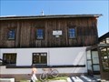
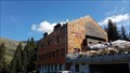
|  Tuxerjochhaus - Hintertux, Tirol, Austria Tuxerjochhaus - Hintertux, Tirol, Austria
in Wikipedia Entries Das Tuxerjochhaus in den Tuxer Alpen in Tirol. posted by: kaschper69 location: Tirol, Austria date approved: 09/09/2019 last visited: 09/09/2019 |
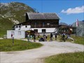
 view gallery view gallerySW3.2 km |  Tuxerjoch Haus - Hintertux, Tirol, Austria Tuxerjoch Haus - Hintertux, Tirol, Austria
in Lodge-Style Accommodations The Tuxerjochhaus was built between 1910 and 1911 at the Tuxerjoch in Tyrol. posted by: kaschper69 location: Tirol, Austria date approved: 09/09/2019 last visited: 09/09/2019 |
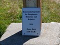
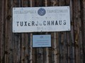 view gallery view gallerySW3.2 km |  2.340 m - Tuxerjoch Haus - Hintertux, Tirol, Austria 2.340 m - Tuxerjoch Haus - Hintertux, Tirol, Austria
in Elevation Signs Das Tuxerjochhaus aus dem Jahre 1910/1911 auf dem Tuxerjoch auf einer Höhe von 2.340 m über Normal Null. posted by: kaschper69 location: Tirol, Austria date approved: 09/09/2019 last visited: 09/09/2019 |
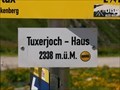 view gallery view gallerySW3.2 km | 2.338 m - Tuxerjoch Haus - Hintertux, Tirol, Austria in Elevation Signs Elevation sign for the Tuxerjoch house on the plateau of the Tuxerjoch at an altitude of 2.338 m above sea level. posted by: kaschper69 location: Tirol, Austria date approved: 09/09/2019 last visited: 09/09/2019 |
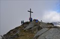
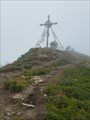
 view gallery view gallerySW3.9 km | 2.338 m - Tuxerjoch - Hintertux, Tirol, Austria in Elevation Signs Christian cross at an altitude of 2.338 m above sea level at the Tuxerjoch, Austria. posted by: kaschper69 location: Tirol, Austria date approved: 09/09/2019 last visited: 09/09/2019 |
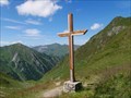 view gallery view gallerySW3.9 km |  Christian Cross - Tuxerjoch, Hintertux, Tirol, Austria Christian Cross - Tuxerjoch, Hintertux, Tirol, Austria
in Christian Crosses Christian cross at the Tuxerjoch, Austria. posted by: kaschper69 location: Tirol, Austria date approved: 09/09/2019 last visited: 09/09/2019 |
 view gallery view gallerySW7.9 km |  1986 - Isse-Alm - Schmirn, Tirol, Austria 1986 - Isse-Alm - Schmirn, Tirol, Austria
in Dated Buildings and Cornerstones Isse-Alm Berghütte aus dem Jahre 1986 bei Schmirn, Austria. posted by: kaschper69 location: Tirol, Austria date approved: 09/08/2019 last visited: 09/05/2019 |
 view gallery view galleryW9.2 km | Naviser Hütte - Navis, Tirol, Austria in Lodge-Style Accommodations The Naviser Hütte is located at an altitude of 1,787 meters in the Navisertal, Tyrol. posted by: kaschper69 location: Tirol, Austria date approved: 08/25/2017 last visited: 08/25/2017 |
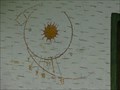 view gallery view galleryW10.1 km |  Sundial - Navis, Tirol, Austria Sundial - Navis, Tirol, Austria
in Sundials Sundial at the outer facade of a house at the hiking park in Navis. posted by: kaschper69 location: Tirol, Austria date approved: 09/30/2017 last visited: 09/29/2017 |
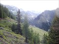 view gallery view galleryW10.1 km |  Naviser Almrunde Navis, Tirol, Austria Naviser Almrunde Navis, Tirol, Austria
in Scenic Hikes Naviser Almrunde Navis, Tirol, Austria posted by:  luzzi-reloaded luzzi-reloaded location: Tirol, Austria date approved: 10/28/2011 last visited: 02/16/2012 |
 view gallery view gallerySW10.6 km | Valsertal Tirol, Austria in Scenic Hikes Valsertal Tirol, Austria posted by: luzzi-reloaded location: Tirol, Austria date approved: 10/28/2011 last visited: 02/16/2012 |
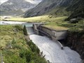 view gallery view gallery SE13.2 km SE13.2 km
|  Zemmbach-Wasserkraftwerk - Bezirk Schwaz, Tirol, A Zemmbach-Wasserkraftwerk - Bezirk Schwaz, Tirol, A
in Hydroelectric Power Stations Ein kleines Wasserkraftwerk zur Energieversorgung der Hütten. posted by: Tharandter location: Tirol, Austria date approved: 09/19/2012 last visited: never |
 view gallery view gallery S13.5 km S13.5 km
|  Rotbachlspitze, 2897 m Rotbachlspitze, 2897 m
in Mountain Summits [DE]Die Rotbachlspitze erhebt sich knapp 3000 Meter inmitten der Zillertaler Alpen, direkt an der ötereichisch-italienischen Grenze. posted by: aendgraend location: Tirol, Austria date approved: 09/26/2015 last visited: never |
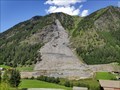 view gallery view gallerySW13.7 km |  Bericht "Gigantischer Felssturz in Vals samt Weihnachtswunder" - Vals, Tirol, Austria Bericht "Gigantischer Felssturz in Vals samt Weihnachtswunder" - Vals, Tirol, Austria
in News Article Locations Bericht "Gigantischer Felssturz in Vals samt Weihnachtswunder" in meinbezirk.at. posted by: kaschper69 location: Tirol, Austria date approved: 09/05/2019 last visited: 09/05/2019 |
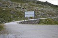 view gallery view galleryS13.7 km |  Willkommen in Südtirol - Grenzübergang Pfitscherjoch Willkommen in Südtirol - Grenzübergang Pfitscherjoch
in Border Crossings Willkommen in Südtirol, der Grenzübergang beim Pfitscherjoch-Haus posted by: aendgraend location: Trentino–Alto Adige, Italy date approved: 09/22/2015 last visited: 08/22/2010 |
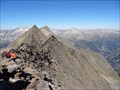 view gallery view gallerySE13.8 km | Schönbichler Horn (3133m) - Zillertaler Alpen, Tirol, A in Mountain Summits Der Gipfel des meistbestiegenen 3000ers in den Ostalpen. /
The summit of the most visited three thousand in the Eastern Alps. posted by: Tharandter location: Tirol, Austria date approved: 09/22/2012 last visited: never |
 view gallery view gallerySE14 km |  Gefallenendenkmal DAV Sektion Berlin - Bezirk Schwaz, Tirol, A Gefallenendenkmal DAV Sektion Berlin - Bezirk Schwaz, Tirol, A
in World War I Memorials and Monuments Gefallenendenkmal der DAV Sektion Berlin. / War memorial of the DAV Section of Berlin. posted by: Tharandter location: Tirol, Austria date approved: 09/19/2012 last visited: never |
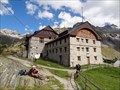
 view gallery view galleryS14 km |  Pfitscherjoch-Haus, 2276 m Pfitscherjoch-Haus, 2276 m
in Hiking and walking trailheads Das Pfitscherjoch-Haus an der Grenze zwischen Österreich und Italien in den Zillertaler Alpen. posted by: aendgraend location: Trentino–Alto Adige, Italy date approved: 09/27/2015 last visited: 08/22/2010 |
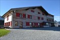
 view gallery view gallerySE14.2 km |  Berliner Hütte (2042m) - Bezirk Schwaz, Tirol, A Berliner Hütte (2042m) - Bezirk Schwaz, Tirol, A
in Remote Backcountry Shelters Die historische Berliner Hütte in den Zillertaler Alpen. posted by: Tharandter location: Tirol, Austria date approved: 02/08/2013 last visited: never |
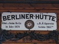 view gallery view gallerySE14.2 km |  Berliner Hütte - Ginzling, Bezirk Schwaz, Tirol, A Berliner Hütte - Ginzling, Bezirk Schwaz, Tirol, A
in Austrian and Swiss National Heritage Sites Die historische Berliner Hütte. posted by: Tharandter location: Tirol, Austria date approved: 02/14/2013 last visited: never |
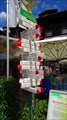 view gallery view gallery E14.5 km E14.5 km
|  Souvenirsshop Mayrhofen, Austria Souvenirsshop Mayrhofen, Austria
in Direction and Distance Arrows Direction and Distance Arrow in front of a tourist shop in Maryrhofen posted by: superstein location: Tirol, Austria date approved: 08/06/2016 last visited: never |
 view gallery view gallery NE14.8 km NE14.8 km
|  Mayrhofen, Austria Mayrhofen, Austria
in Train Stations/Depots Mayrhofen is the end of the Zillertalbahn posted by: superstein location: Tirol, Austria date approved: 11/20/2016 last visited: never |
 view gallery view galleryE15.1 km | Filzenkogel, Mayrhofen, Austria in Mountain Summits Auf dem Berg "Filzenkogel" steht ein Gipfelkreuz, an dem auch ein Gipfelbuch zu finden ist *** At the top of the mountain Filzenkogel is a summit cross posted by: 4spring location: Tirol, Austria date approved: 04/30/2017 last visited: 07/31/2015 |
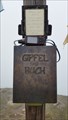 view gallery view galleryE15.1 km |  Filzenkogel, Mayrhofen, Austria Filzenkogel, Mayrhofen, Austria
in Summit Registers Auf dem Filzenkogel steht ein Gipfelkreuz, an dem der Behälter mit dem Gipfelbuch zu finden ist *** This summit register book is at the summit cross at the top of the mountain Filzenkogel posted by: 4spring location: Tirol, Austria date approved: 04/27/2017 last visited: 07/31/2015 |
|