 view gallery view gallery SE4.2 km SE4.2 km
|   Mowich Mowich
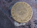
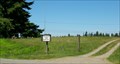
in U.S. Benchmarks A USGS Cascades Volcano Observatory marker located near the shores of Mowich Lake, at the end of WA 165, Mountain Meadows Rd. posted by:  Hop2it Hop2it location: Washington date approved: 08/30/2007 last visited: 08/27/2007 |
 view gallery view gallery NW8.4 km NW8.4 km
|  Latitude 47 Latitude 47
in Bloggers The official blog of Geocaching.com! posted by: Blue Man location: Washington date approved: 05/26/2010 last visited: 12/27/2022 |
 view gallery view gallery E9.3 km E9.3 km
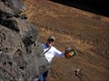
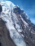
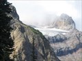
|  Carbon Glacier - Mt. Rainier, WA Carbon Glacier - Mt. Rainier, WA
in Glaciers Carbon Glacier is located on the north slope of Mount Rainier within Mount Rainier National Park. It's snout lies at 3,500 feet above sea level and can be accessed via a 4 mile hike out of Ipsut Creek Campground. posted by:  Hikenutty Hikenutty location: Washington date approved: 03/29/2008 last visited: 03/30/2008 |
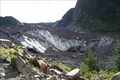
 view gallery view galleryE9.3 km |  ORIGIN - Carbon River ORIGIN - Carbon River
in River Origins, Destinations and Confluences Carbon River originates at the snout of Carbon Glacier, which is located on the north slope of Mount Rainier within Mount Rainier National Park. posted by: Hikenutty location: Washington date approved: 12/30/2007 last visited: 10/21/2021 |
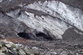
 view gallery view galleryE9.3 km |  Carbon Glacier - Mount Rainier National Park, WA Carbon Glacier - Mount Rainier National Park, WA
in American Guide Series Carbon Glacier is located on the north slope of Mount Rainier within Mount Rainier National Park. It's snout lies at 3,500 feet above sea level and can be accessed via a 4 mile hike out of Ipsut Creek Campground. posted by: Hikenutty location: Washington date approved: 12/25/2007 last visited: 12/26/2007 |
 view gallery view gallerySE9.8 km | Observation Rock in U.S. Benchmarks on top of a red volcanic lava cone on the side of Mt Rainier at an elevation of 8376 feet posted by: TeamHenryBear location: Washington date approved: 10/29/2008 last visited: 08/04/2013 |
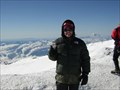 view gallery view gallerySE16.1 km |  Mt. Rainier Summit, Washington's High Point Mt. Rainier Summit, Washington's High Point
in Mountain Summits Columbia Crest posted by: The Mercury Project location: Washington date approved: 09/08/2005 last visited: 07/16/2004 |
 view gallery view galleryE16.1 km | Winthrop Glacier - Mt. Rainier National Park in Glaciers Winthrop Glacier on the NE side of Mt. Rainier posted by: Prying Pandora location: Washington date approved: 09/07/2008 last visited: 07/07/2018 |
 view gallery view gallerySE16.9 km |  Mount Rainier National Park - Ashford WA Mount Rainier National Park - Ashford WA
in Wikipedia Entries Mount Rainier National Park-use the address 39000 State Route 706 E, Ashford, WA 98304. This will take you on SR 706 east past the Administration Building to the Nisqually Entrance. posted by: Don.Morfe location: Washington date approved: 04/14/2024 last visited: 04/14/2024 |
 view gallery view gallery S17.7 km S17.7 km
|  Gobbler's Knob Gobbler's Knob
in Look-Out Towers Gobbler's Knob Lookout in Mt. Rainier National Park posted by: Prying Pandora location: Washington date approved: 09/08/2010 last visited: never |
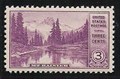 view gallery view galleryS17.9 km |  Mt. Rainier from the Mirror Lakes Mt. Rainier from the Mirror Lakes
in Philatelic Photographs This is the site of the Asahel Curtis photograph that was used for the 1934 US 3c National Parks postage stamp. posted by: hykesj location: Washington date approved: 06/04/2012 last visited: 01/24/2021 |
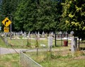
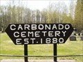 view gallery view galleryNW18.2 km |  CARBONADO CEMETERY CARBONADO CEMETERY
in Worldwide Cemeteries The Carbonado Cemetery was established in 1880. the cemetery is in very clean condition except many of the stones are unreadable because of a build of lichen.
posted by: The-DuHawks location: Washington date approved: 05/08/2008 last visited: 06/27/2009 |
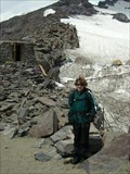 view gallery view gallerySE19 km | ") Camp Muir, Mount Rainier National Park Camp Muir, Mount Rainier National Park
in National Parks (U.S.) Camp Muir is located on the side of Mount Rainier just above the 10,000 foot level. posted by: run4cache location: Washington date approved: 07/16/2007 last visited: 10/21/2021 |
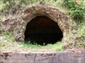 view gallery view galleryNW19.2 km |  Coke Ovens at Wilkeson, Washington Coke Ovens at Wilkeson, Washington
in Ovens and Kilns The remains of a large coking operation in Wilkeson, Washington. posted by: adh73 location: Washington date approved: 07/05/2009 last visited: 08/17/2020 |
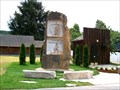 view gallery view galleryNW19.6 km |  Coal Miners and Quarry Workers - Wilkeson, WA Coal Miners and Quarry Workers - Wilkeson, WA
in Occupational Monuments Monument at Wilkeson, Pierce County, Washington to the local coal miners and workers in the local sandstone quarry. posted by: adh73 location: Washington date approved: 08/01/2009 last visited: 09/12/2010 |
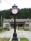 view gallery view galleryNW19.6 km |  Town Hall Clock - Wilkeson, WA Town Hall Clock - Wilkeson, WA
in Town Clocks Freestanding Clock in front of the Wilkeson Town Hall posted by: Prying Pandora location: Washington date approved: 09/16/2010 last visited: 09/12/2010 |
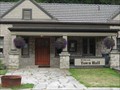 view gallery view galleryNW19.6 km |  Wilkeson, WA Wilkeson, WA
in City and Town Halls The town hall of Wilkeson, WA posted by: Prying Pandora location: Washington date approved: 09/16/2010 last visited: 09/12/2010 |
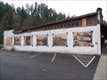 view gallery view galleryNW19.6 km |  Murals in Wilkeson, WA Murals in Wilkeson, WA
in Murals SORRY TO REPORT, THESE MURALS HAVE BEEN PAINED OVER...! :( posted by: The-DuHawks location: Washington date approved: 02/02/2010 last visited: never |
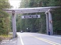
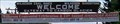 view gallery view galleryNW20 km |  Gateway to Carbon Glacier - Wilkeson, Washington Gateway to Carbon Glacier - Wilkeson, Washington
in Welcome Signs This is the sign that greets visitors to Wilkeson, Washington. posted by: adh73 location: Washington date approved: 07/24/2009 last visited: 03/13/2012 |
 view gallery view gallerySE20.6 km | Fryingpan Glacier - Mt. Rainier National Park in Glaciers Fryingpan Glacier on Little Tahoma Peak posted by: Prying Pandora location: Washington date approved: 09/07/2008 last visited: 06/14/2013 |
 view gallery view galleryS20.6 km |  Copper Creek Hut Copper Creek Hut
in Remote Backcountry Shelters This free hut is operated by the Mount Tahoma Trails Association, and could sleep 14 guests. posted by: gleek location: Washington date approved: 12/19/2005 last visited: never |
 view gallery view galleryNW20.6 km | Wilkeson, Washington Catholic Cemetery in Worldwide Cemeteries This is the Catholic cemetery in Wilkeson, Pierce County, Washington. posted by: adh73 location: Washington date approved: 07/01/2009 last visited: 10/06/2011 |
 view gallery view galleryNW20.9 km | Wilkeson, Washington Town Cemetery in Worldwide Cemeteries This is the town cemetery for Wilkeson, Pierce County, Washington. posted by: adh73 location: Washington date approved: 06/30/2009 last visited: 03/13/2012 |
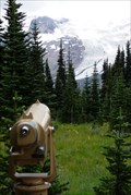 view gallery view galleryE20.9 km |  BINO - Mt. Rainier and Emmons Glacier - Sunrise, Mt. Rainier Nat'l Park BINO - Mt. Rainier and Emmons Glacier - Sunrise, Mt. Rainier Nat'l Park
in Coin-Op Binoculars This beautiful view of Mt. Rainier and Emmons Glacier is located beside the Sunrise Visitor Center in Mt. Rainier National Park. posted by: Hikenutty location: Washington date approved: 08/20/2007 last visited: 08/20/2007 |
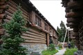 view gallery view galleryE20.9 km |  Sunrise Visitor Center - Sunrise, Mt. Rainier National Park Sunrise Visitor Center - Sunrise, Mt. Rainier National Park
in NRHP Historic Districts - Contributing Buildings The Sunrise Visitor Center, originally the Community House, was built from 1939-1943. It has always been used as an interpretive museum. posted by: Hikenutty location: Washington date approved: 08/25/2007 last visited: 07/17/2005 |
|