 view gallery view gallery E17.2 km E17.2 km
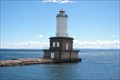
|   Big Bay Point Lighthouse - Big Bay MI Big Bay Point Lighthouse - Big Bay MI
in Coastal Lighthouses Big Bay Point Lighthouse - Big Bay MI posted by:  kJfishman kJfishman location: Michigan date approved: 08/05/2008 last visited: 09/20/2016 |
 view gallery view galleryE17.2 km |  Big Bay MI Anatomy of a Murder - 1959 Big Bay MI Anatomy of a Murder - 1959
in Movie Locations Big Bay MI Anatomy of a Murder - 1959 Big Bay Inn (Thunder Bay Inn) posted by: kJfishman location: Michigan date approved: 08/21/2009 last visited: 08/21/2009 |
 view gallery view galleryE17.2 km |  Big Bay Point Lighthouse Bed & Breakfast - Big Bay MI Big Bay Point Lighthouse Bed & Breakfast - Big Bay MI
in Lighthouse Bed and Breakfasts Big Bay Point Lighthouse Bed 7 Breakfast - Big Bay MI posted by: kJfishman location: Michigan date approved: 08/06/2008 last visited: 12/13/2019 |
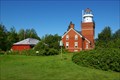 view gallery view galleryE17.2 km |  Big Bay Point Lighthouse - Big Bay MI Big Bay Point Lighthouse - Big Bay MI
in Official Local Tourism Attractions Big Bay Point Lighthouse posted by: kJfishman location: Michigan date approved: 08/20/2011 last visited: 12/13/2019 |
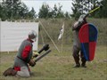 view gallery view gallery SE19.5 km SE19.5 km
|  Ishpeming Renaissance Festival -Ishpeming, MI Ishpeming Renaissance Festival -Ishpeming, MI
in Renaissance Fairs Annual Renaissance Fair held in a small Upper Peninsula town. posted by:  linkys linkys location: Michigan date approved: 08/13/2011 last visited: never |
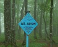
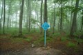 view gallery view gallery SW22 km SW22 km
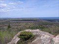
|  Mount Arvon - Highest Point in Michigan Mount Arvon - Highest Point in Michigan
in Mountain Summits 1,979 feet is not very high for a summit, but it is quite a trip. Only about 14 miles from L'Anse, it takes 28 miles of logging roads to get there.
posted by: S5280ft location: Michigan date approved: 07/06/2008 last visited: 08/11/2016 |
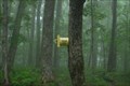 view gallery view gallerySW22 km |  Mount Arvon - Highest Point in Michigan Mount Arvon - Highest Point in Michigan
in Summit Registers 1,979 feet is not very high for a summit, but it is quite a trip. Only about 14 miles from L'Anse, it takes 28 miles of logging roads to get there. The summit is completely tree covered. Good for a paper company, bad for a scenic view.
posted by: S5280ft location: Michigan date approved: 07/08/2008 last visited: 08/11/2016 |
 view gallery view gallerySW22 km |  Mount Arvon - Highest Point in Michigan Mount Arvon - Highest Point in Michigan
in U.S. Benchmarks 1,979 feet is not very high for a summit, but it is quite a trip. Only about 14 miles from L'Anse, it takes 28 miles of logging roads to get there. The summit is completely tree covered. Good for a paper company, bad for a scenic view. posted by: S5280ft location: Michigan date approved: 07/07/2008 last visited: 08/11/2016 |
 view gallery view gallerySW22 km |  Mount Arvon - Highest Point in Michigan Mount Arvon - Highest Point in Michigan
in Elevation Signs 1,979 feet is not very high, but it is quite a trip. Only about 14 miles from L'Anse, it takes 28 miles of logging roads to get there.
posted by: S5280ft location: Michigan date approved: 07/06/2008 last visited: 08/11/2016 |
 view gallery view gallerySW22 km |  Mount Arvon - Highest Point in Michigan Mount Arvon - Highest Point in Michigan
in Geographic High Points 1,979 feet is not very high, but it is quite a trip. Only about 14 miles from L'Anse, it takes 28 miles of logging roads to get there. posted by: S5280ft location: Michigan date approved: 07/06/2008 last visited: 08/11/2016 |
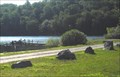
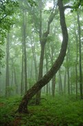 view gallery view gallerySW22 km |  Trail Tree on Mount Arvon Trail Tree on Mount Arvon
in Native American Trail Trees This tree is located on Mount Arvon, the highest point in Michigan. The summit is completely tree covered, affording no view. It is likely that this tree pointed to the village that is the present town of L'Anse at the base of the Keweenaw Bay. posted by: S5280ft location: Michigan date approved: 07/12/2008 last visited: 04/22/2012 |
 view gallery view gallery S37.3 km S37.3 km
|  Sam Cohodas Lodge / Sam Cohodas Sam Cohodas Lodge / Sam Cohodas
in Michigan Historical Markers Located southwest off US-41 about 2 miles north of Champion, MI on CR-IM. The lodge is clearly private and the owners clearly want to keep it that way. posted by: S5280ft location: Michigan date approved: 08/20/2006 last visited: 03/18/2018 |
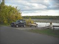 view gallery view galleryS37.8 km |  Lake Michigamme east end Lake Michigamme east end
in Boat Ramps Lake Michigamme east end in Lake Michigamme State Park posted by: kJfishman location: Michigan date approved: 08/28/2009 last visited: 08/28/2009 |
 view gallery view galleryS37.8 km |  Lake Michigamme - Champion MI Lake Michigamme - Champion MI
in Natural Lakes Lake Michigamme - Champion MI posted by: kJfishman location: Michigan date approved: 03/20/2016 last visited: never |
 view gallery view gallery W39.9 km W39.9 km
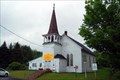
|  59 Zeba Indian Church, L'Anse, MI 59 Zeba Indian Church, L'Anse, MI
in Historic United Methodist Sites On the southeast corner of Whirl-I-Gig and Zeba Roads. Take Main Street/Skanee north out of L'Anse and after about 2.9 miles, bear left on Whirl-I-Gig until you come to Zeba Road on your right. Plenty of streetside parking posted by: S5280ft location: Michigan date approved: 07/06/2008 last visited: 10/25/2011 |
 view gallery view galleryW39.9 km |  Kewawenon Mission - Zeba, MI Kewawenon Mission - Zeba, MI
in U.S. National Register of Historic Places On the southeast corner of Whirl-I-Gig and Zeba Roads. Take Main Street/Skanee north out of L'Anse and after about 2.9 miles, bear left on Whirl-I-Gig until you come to Zeba Road on your right. Plenty of streetside parking. posted by: S5280ft location: Michigan date approved: 07/08/2008 last visited: never |
 view gallery view galleryW39.9 km |  Zeba Indian Mission United Methodist Church Zeba Indian Mission United Methodist Church
in This Old Church On the southeast corner of Whirl-I-Gig and Zeba Roads. Take Main Street/Skanee north out of L'Anse and after about 2.9 miles, bear left on Whirl-I-Gig until you come to Zeba Road on your right. Plenty of streetside parking. posted by: S5280ft location: Michigan date approved: 07/06/2008 last visited: never |
 view gallery view galleryW39.9 km | Zeba Indian United Methodist Church in Michigan Historical Markers On the southeast corner of Whirl-I-Gig and Zeba Roads (I'm not kidding). Take Main Street/Skanee north out of L'Anse and after about 2.9 miles, bear left on Whirl-I-Gig until you come to Zeba Road on your right. Plenty of streetside parking. posted by: S5280ft location: Michigan date approved: 08/20/2006 last visited: never |
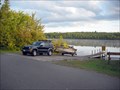
 view gallery view gallerySW40.1 km | Lake Michigamme west end in Boat Ramps Lake Michigamme west end posted by: kJfishman location: Michigan date approved: 08/28/2009 last visited: 08/28/2009 |
 view gallery view galleryW42 km | Portage Lake Lower Entry Light - Jacobsville in Coastal Lighthouses Portage Lake Lower Entry Light - Jacobsville posted by: kJfishman location: Michigan date approved: 08/11/2008 last visited: 08/11/2008 |
 view gallery view gallerySE42.2 km |  Hogback Mountain Hogback Mountain
in Scenic Overlooks Hogback Mountain near Marquette, Michigan. posted by: Team B Squared location: Michigan date approved: 01/20/2009 last visited: never |
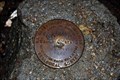
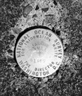 view gallery view galleryW42.3 km | PID RL: 1543 - Jacobsville MO in U.S. Benchmarks PID RL: 1543 - Jacobsville MO posted by: kJfishman location: Michigan date approved: 01/22/2018 last visited: never |
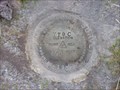 view gallery view gallery NW42.5 km NW42.5 km
| TT 9 C 1937 USGS in U.S. Benchmarks USGS BENCH MARK posted by: Z15 location: Michigan date approved: 05/24/2006 last visited: never |
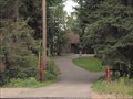
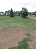 view gallery view gallerySE42.5 km |  Al Quaal Recreation Area DGC - Ishpeming, MI Al Quaal Recreation Area DGC - Ishpeming, MI
in Disc Golf Courses A somewhat hilly course in a small town in Michigan's upper peninsula. posted by: linkys location: Michigan date approved: 09/03/2011 last visited: never |
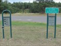 view gallery view gallerySE42.6 km |  Al Quaal Recreation Area Fitness Course - Ishpeming, MI Al Quaal Recreation Area Fitness Course - Ishpeming, MI
in Fitness Trails Fitness course located in hilly terrain in a large city park. posted by: linkys location: Michigan date approved: 08/23/2011 last visited: never |
|