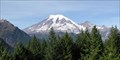
 view gallery view gallery NW0.2 km NW0.2 km
|   Backbone Ridge View Point, Washington Backbone Ridge View Point, Washington
in Scenic Roadside Look-Outs The Backbone Ridge View Point is located along the Stevens Canyon Road in Mt. Rainier National Park. posted by:  Volcanoguy Volcanoguy location: Washington date approved: 11/16/2006 last visited: 10/16/2010 |
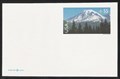 view gallery view galleryNW0.3 km |  Mount Rainier from Lewis County, WA Mount Rainier from Lewis County, WA
in Philatelic Photographs The southeast face of Mt. Rainier as seen from Stevens Canyon Rd. is shown on this international rate airmail postal card issued in 1999. posted by: hykesj location: Washington date approved: 07/29/2021 last visited: never |
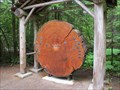 view gallery view gallery NE4 km NE4 km
|  Ohanapecosh Tree Ring Display - Mt. Rainier National Park Ohanapecosh Tree Ring Display - Mt. Rainier National Park
in Exceptional Tree Growth Ring Displays Located at the rear of the Visitor Center, this is one of several growth ring displays in the park. posted by: ChapterhouseInc location: Washington date approved: 07/08/2013 last visited: 06/16/2013 |
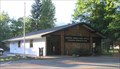
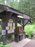 view gallery view galleryNE4 km |  Ohanapecosh Campground - Mt Rainer National Park Ohanapecosh Campground - Mt Rainer National Park
in Campgrounds One of several campgrounds found in the park. posted by: ChapterhouseInc location: Washington date approved: 07/07/2013 last visited: 12/29/2022 |
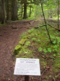 view gallery view galleryNE4 km |  Ohanapecosh Hot Springs Nature Trail - Mt Rainier Ohanapecosh Hot Springs Nature Trail - Mt Rainier
in Self Guided Walks and Trails A short loop trail around the visitor center provides a unique glimpse at one of the many ecosystems in the park. posted by: ChapterhouseInc location: Washington date approved: 07/07/2013 last visited: 06/14/2013 |
 view gallery view gallery S4.3 km S4.3 km
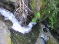
|  Grant Purcell Falls Grant Purcell Falls
in Waterfalls Located in La Wis Wis Campground just outside Rainier National Park, where a short trail leads to a small, but very approachable series of small cascades. posted by:  krazykatzen krazykatzen location: Washington date approved: 08/18/2008 last visited: never |
 view gallery view gallery SE4.7 km SE4.7 km
| Palisades View Point, Washington in Scenic Roadside Look-Outs The Palisades View Point is located along U.S. Hwy. 12 about 2.5 miles east of junction with Wash. Hwy. 123. posted by: Volcanoguy location: Washington date approved: 11/15/2006 last visited: 12/29/2022 |
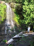
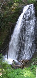
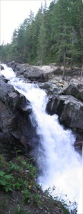 view gallery view galleryNE5.8 km | Silver Falls in Waterfalls A powerful waterfall near the Ohanapecosh entrance to Rainier National Park. posted by: krazykatzen location: Washington date approved: 08/17/2008 last visited: 08/31/2011 |
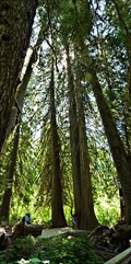 view gallery view galleryNE6.4 km |  Grove of the Patriarchs Trail - Mt Rainier National Park - Packwood, WA Grove of the Patriarchs Trail - Mt Rainier National Park - Packwood, WA
in Scenic Hikes Like walking thru a fantasy movie to the giants. Then you realize how long these trees have been here. This is a great trail to walk, it will take awhile since you will be looking all around you. posted by: nomadwillie location: Washington date approved: 03/06/2013 last visited: never |
 view gallery view galleryNE6.4 km | Falls Creek Falls in Waterfalls A lovely tiered cascade visible right from the Stevens Canyon Road in Rainier National Park. There is a sign from the road to indicate you've arrived. posted by: krazykatzen location: Washington date approved: 08/17/2008 last visited: 06/14/2013 |
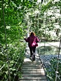 view gallery view galleryNE6.9 km |  Grove of the Patriarchs Trail - Mt. Rainier National Park - Packwood WA Grove of the Patriarchs Trail - Mt. Rainier National Park - Packwood WA
in Hiking Path Footbridges The suspension bridge crosses the Ohanapecosh River on the way to the Grove of the Patriarchs posted by: nomadwillie location: Washington date approved: 02/28/2013 last visited: never |
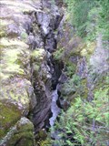 view gallery view galleryNW6.9 km | Box Canyon View Point, Washington in Scenic Roadside Look-Outs The Box Canyon View Point is located along the Stevens Canyon Road in Mt. Rainier National Park. posted by: Volcanoguy location: Washington date approved: 11/16/2006 last visited: 10/11/2015 |
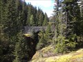 view gallery view galleryNW6.9 km |  Box Canyon Overlook Bridge - Mt Rainier National Park Box Canyon Overlook Bridge - Mt Rainier National Park
in Stone Bridges Located along Stevens Canyon Rd, it provides access to trails and a nice view of the canyon. posted by: ChapterhouseInc location: Washington date approved: 07/06/2013 last visited: 10/11/2015 |
 view gallery view galleryNW9.7 km | Middle Martha Falls in Waterfalls A short 3/4 mile (one way) hike down the Wonderland Trail to a small footbridge crossing Unicorn Creek. The falls are located within Rainier National Park. posted by: krazykatzen location: Washington date approved: 08/17/2008 last visited: 09/03/2008 |
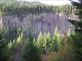
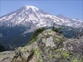 view gallery view galleryNW11.9 km |  Plummer Peak Plummer Peak
in Mountain Summits A short & steep hike up a rugged ridge with spectacular views in Rainier National Park. Round trip is about 3.5 miles with 1,480 ft elevation gain. posted by: krazykatzen location: Washington date approved: 08/18/2008 last visited: 01/24/2021 |
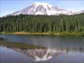
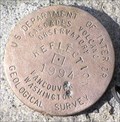 view gallery view galleryNW11.9 km |  USGS Reflection, Oregon USGS Reflection, Oregon
in U.S. Benchmarks This benchmark is located at Reflection Lake in Mt. Rainier National Park. posted by: Volcanoguy location: Washington date approved: 11/16/2006 last visited: 07/15/2011 |
 view gallery view galleryNW11.9 km | Reflection Lake View Point, Washington in Scenic Roadside Look-Outs The Reflection Lake View Point is located along the Stevens Canyon Road. posted by: Volcanoguy location: Washington date approved: 11/16/2006 last visited: 10/19/2017 |
 view gallery view gallery SW12.4 km SW12.4 km
|  Blanton’s Market Penny Smasher Blanton’s Market Penny Smasher
in Penny Smashers Penny Smasher in entrance to Blanton’s Market in Packwood, Washington. posted by: Volcanoguy location: Washington date approved: 11/19/2006 last visited: 06/14/2013 |
 view gallery view gallerySW12.6 km |  Packwood, WA, 98361 Packwood, WA, 98361
in U.S. Post Offices The Packwood Post Office. posted by: Volcanoguy location: Washington date approved: 11/01/2006 last visited: 12/29/2022 |
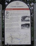 view gallery view gallerySW12.7 km |  Packwood Packwood
in Washington Historical Markers This sign is along U.S. Hwy. 12 in Packwood. posted by: Volcanoguy location: Washington date approved: 11/23/2006 last visited: 10/25/2015 |
 view gallery view galleryNW13.2 km | Inspiration View Point, Washington in Scenic Roadside Look-Outs The Inspiration View Point is located along the Stevens Canyon Road in Mt. Rainier National Park. posted by: Volcanoguy location: Washington date approved: 11/17/2006 last visited: 07/17/2005 |
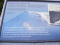 view gallery view galleryNW13.4 km | Inspired to Preserve Mount Rainier National Park - Paradise WA in Washington Historical Markers Inspired to Preserve Mount Rainier National Park marker is located at Paradise Road East in Paradise, postal code Packwood WA 98361. posted by: Don.Morfe location: Washington date approved: 04/15/2024 last visited: 04/15/2024 |
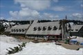
 view gallery view galleryNW13.4 km |  Paradise Inn - Mount Rainier National Park Paradise Inn - Mount Rainier National Park
in U.S. National Register of Historic Places The Paradise Inn was built in 1917 in the historic rustic park-style of architecture. posted by: Hikenutty location: Washington date approved: 05/29/2007 last visited: 06/14/2023 |
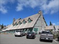
 view gallery view galleryNW13.4 km |  Paradise Inn - Mount Rainier National Park Paradise Inn - Mount Rainier National Park
in Lodge-Style Accommodations Paradise Inn was built in 1917 and is designed in the rustic park-style of architecture. The building has 118 rooms and is open from May through September. posted by: Hikenutty location: Washington date approved: 05/29/2007 last visited: 05/25/2023 |
 view gallery view galleryNW13.4 km |  Paradise Inn (Washington) Paradise Inn (Washington)
in Wikipedia Entries One of several lodges for visitors to stay the night in Mt Rainier National Park. posted by: ChapterhouseInc location: Washington date approved: 07/06/2013 last visited: 03/05/2020 |
|