 view gallery view gallery E0.2 km E0.2 km
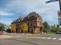
|   Bank of Washburn – Washburn, WI Bank of Washburn – Washburn, WI
in U.S. National Register of Historic Places This historical brownstone building now serves as a visitor center, museum, art gallery, and antiques store. posted by:  wildernessmama wildernessmama location: Wisconsin date approved: 10/15/2013 last visited: 05/21/2021 |
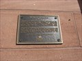 view gallery view galleryE0.2 km |  Bank of Washburn,1890 – Washburn, WI Bank of Washburn,1890 – Washburn, WI
in Signs of History This historical plaque tells the history of Washburn’s bank. posted by: wildernessmama location: Wisconsin date approved: 10/13/2013 last visited: 05/21/2021 |
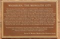 view gallery view galleryE0.2 km | Washburn, The Monolith City – Washburn, WI in Signs of History This brownstone monolith stands to the right of the historical bank building in downtown Washburn. posted by: wildernessmama location: Wisconsin date approved: 10/13/2013 last visited: 05/21/2021 |
 view gallery view gallery SW0.2 km SW0.2 km
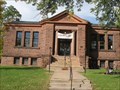
| Washburn Public Library – Washburn, WI in U.S. National Register of Historic Places Built in 1904, this library was constructed using locally quarried brownstone. posted by: wildernessmama location: Wisconsin date approved: 10/15/2013 last visited: 11/20/2019 |
 view gallery view gallerySW0.2 km |  Washburn Carnegie Library – Washburn, WI Washburn Carnegie Library – Washburn, WI
in Carnegie Library Buildings Built in 1904, this library was constructed using locally quarried brownstone. posted by: wildernessmama location: Wisconsin date approved: 10/15/2013 last visited: never |
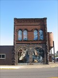 view gallery view galleryE0.3 km |  Vulcan’s Forge – Washburn, WI Vulcan’s Forge – Washburn, WI
in Murals This extensive mural is painted on the brick Iron Works building and on the arched window spaces on the second floor. posted by: wildernessmama location: Wisconsin date approved: 10/14/2013 last visited: never |
 view gallery view gallery N0.3 km N0.3 km
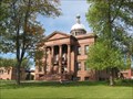
| Bayfield County Courthouse – Washburn, WI in U.S. National Register of Historic Places A marker is located on the front lawn of the Bayfield Country Courthouse to tell more about the history of this building. posted by: wildernessmama location: Wisconsin date approved: 10/15/2013 last visited: never |
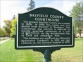 view gallery view galleryN0.3 km | Bayfield County Courthouse – Washburn, WI in Signs of History This historical marker is located on the front lawn of the Bayfield Country Courthouse. posted by: wildernessmama location: Wisconsin date approved: 10/15/2013 last visited: never |
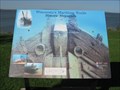
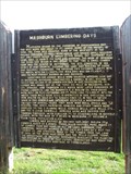 view gallery view gallerySW1 km | Washburn Lumbering Days / The Hines Lumber Company – Washburn, WI in Signs of History This double sided marker tells about the lumber industry that took place in the early days of Washburn’s history. posted by: wildernessmama location: Wisconsin date approved: 10/13/2013 last visited: never |
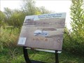 view gallery view gallerySW1 km | Washburn Historic Waterfront, Bigelow / Hines Railroad Trestle: Wisconsin's Maritime Trails - Washburn, WI in Signs of History This marker is part of the waterfront series and tells about one of the first sawmills in this community. posted by: wildernessmama location: Wisconsin date approved: 10/13/2013 last visited: never |
 view gallery view gallerySW1.3 km | The Sprague Well Historical Landmark – Washburn, WI in Signs of History This artesian well is historic as well as a great place to fill up the water bottles. posted by: wildernessmama location: Wisconsin date approved: 10/16/2013 last visited: 05/25/2021 |
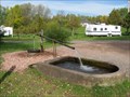 view gallery view gallerySW1.3 km |  The Sprague Well - Washburn, WI The Sprague Well - Washburn, WI
in Artesian Well This artesian well is historic as well as a great place to fill up the water bottles. posted by: wildernessmama location: Wisconsin date approved: 10/15/2013 last visited: 05/25/2021 |
  NW1.6 km NW1.6 km
|  Wash No 1 - 1953 near Washburn, Wisconsin Wash No 1 - 1953 near Washburn, Wisconsin
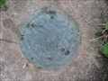
in U.S. Benchmarks The "Wash No 1 1953" reference mark located on the west side of a cemetery located on the north end of Washburn, Wisconsin. posted by: geegis location: Wisconsin date approved: 07/16/2008 last visited: never |
 view gallery view gallery W1.8 km W1.8 km
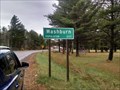
|  Washburn, Wisconsin USA Washburn, Wisconsin USA
in Population Signs Population sign for the town of Washburn in Bayfield County, Wisconsin posted by: MountainWoods location: Wisconsin date approved: 11/04/2015 last visited: 05/25/2021 |
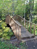 view gallery view gallery NE3.5 km NE3.5 km
|  Houghton Falls Trail Bridge – Washburn, WI Houghton Falls Trail Bridge – Washburn, WI
in Hiking Path Footbridges This pretty arched bridge is located on the Houghton Trail between the falls and the Lake Superior shoreline posted by: wildernessmama location: Wisconsin date approved: 10/15/2013 last visited: never |
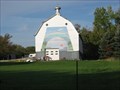 view gallery view galleryN4 km | Rainbow Barn – rural Washburn, WI in Murals On one of the most photographed barns in the area, this mural depicts beautiful wonders in the sky. posted by: wildernessmama location: Wisconsin date approved: 10/16/2013 last visited: never |
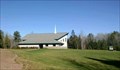 view gallery view gallerySW4.5 km |  Grace Bible Fellowship - Washburn, WI USA Grace Bible Fellowship - Washburn, WI USA
in Country Churches An Evangelical Free church in rural Bayfield County, Wisconsin posted by: MountainWoods location: Wisconsin date approved: 10/30/2015 last visited: 10/25/2015 |
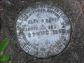
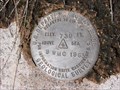 view gallery view galleryW4.7 km | Elevation BM (739 ft) in Bayfield County, WI in U.S. Benchmarks An elevation benchmark disk stamped "739 - 9 WMC 1963" located near Sioux River in Bayfield County, WI. posted by: geegis location: Wisconsin date approved: 07/10/2008 last visited: never |
 view gallery view galleryN5 km | Bayfield County, WI - TT 164L in U.S. Benchmarks This benchmark is located off the west side of Highway 13 as you head north of Washburn, Wisconsin. posted by: geegis location: Wisconsin date approved: 07/05/2008 last visited: never |
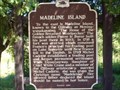 view gallery view galleryN5.6 km |  Madeline Island Madeline Island
in Wisconsin Historical Markers Located at wayside on Hwy 13 north of Washburn. posted by:  Team LightningBugs Team LightningBugs location: Wisconsin date approved: 08/28/2008 last visited: 08/04/2003 |
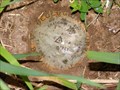
 view gallery view galleryN5.6 km | NGS Benchmark - Sioux 1978 - Bayfield County, Wisconsin in U.S. Benchmarks A NGS horizontal control mark located near historical marker on Highway 13 north of Washburn, Wisconsin. posted by: geegis location: Wisconsin date approved: 06/23/2008 last visited: 10/12/2013 |
 view gallery view galleryW7.2 km | USGS Elevation BM "27 WMC 1963" - Bayfield County, Wisconsin in U.S. Benchmarks A USGS elevation benchmark located on Wisconsin DNR land in Bayfield County, Wisconsin near the intersection of Lucia Road and Church Corner Road. posted by: geegis location: Wisconsin date approved: 06/29/2008 last visited: never |
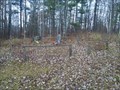 view gallery view galleryW7.4 km |  Church Corner Cemetery - Washburn, WI USA Church Corner Cemetery - Washburn, WI USA
in Worldwide Cemeteries A tiny cemetery -- once a churchyard cemetery -- in rural Bayfield County, Wisconsin posted by: MountainWoods location: Wisconsin date approved: 10/29/2016 last visited: 10/25/2016 |
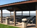 view gallery view gallery S8.2 km S8.2 km
|  Kiwanis Picnic Pavilion – Ashland, WI Kiwanis Picnic Pavilion – Ashland, WI
in Kiwanis International Markers This picnic pavilion was built by the Ashland Kiwanis Club in 1979. posted by: wildernessmama location: Wisconsin date approved: 10/19/2013 last visited: 05/22/2021 |
 view gallery view galleryS8.2 km | Schooner Lucerne Historic Shipwreck: Wisconsin’s Maritime Trails - Ashland, WI in Signs of History This historical marker tells about the schooner “Lucerne” which sank near here in 1886. posted by: wildernessmama location: Wisconsin date approved: 10/13/2013 last visited: 05/22/2021 |
|