 view gallery view gallery NW18 km NW18 km
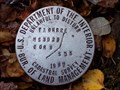
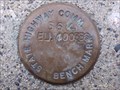
|   Confederate Gulch Road Cadastral Survey Disk. Confederate Gulch Road Cadastral Survey Disk.
in U.S. Benchmarks This is a cadastral survey disk located down Confederate Gulch Road. posted by:  skeezicks skeezicks location: Montana date approved: 10/15/2007 last visited: never |
 view gallery view gallery N18.3 km N18.3 km
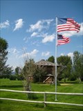
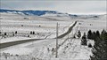
|  Fort Logan - Meagher County, MT Fort Logan - Meagher County, MT
in Military Installations Established 1 November, 1869 as Camp Baker for the protection of the Fort Benton to Helena freight road, as well as area miners and settlers. posted by: CerealBoxMonsters location: Montana date approved: 08/09/2010 last visited: never |
 view gallery view gallery SE20.3 km SE20.3 km
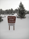
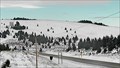
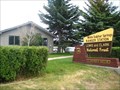
|  Skidway Cross-Country Trailhead - White Sulphur Springs, MT Skidway Cross-Country Trailhead - White Sulphur Springs, MT
in Cross Country Ski Trailheads Located just off of Hwy 12 bewteen Townsend and White Sulpur Springs, in Helena National Forest. This trail is suitable for cross-country skiing and/or snowshoeing. A wonderful "known only by the locals" location in the Big Belt Mountains. posted by: CerealBoxMonsters location: Montana date approved: 01/30/2010 last visited: never |
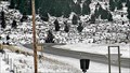 view gallery view gallerySE21.9 km |  Deep Creek West Corner Camera - White Sulphur Springs, MT Deep Creek West Corner Camera - White Sulphur Springs, MT
in Web Cameras This is one of 73 (as of January 2017) Road Weather Information System cameras operated by the Montana Department of Transportation to aid motorists as they make their way across BIG SKY Country. posted by:  T0SHEA T0SHEA location: Montana date approved: 01/12/2017 last visited: never |
 view gallery view gallerySE22 km | Deep Creek West Camera - White Sulphur Springs, MT in Web Cameras This is one of 73 (as of January 2017) Road Weather Information System cameras operated by the Montana Department of Transportation to aid motorists as they make their way across BIG SKY Country. posted by: T0SHEA location: Montana date approved: 01/12/2017 last visited: never |
 view gallery view gallerySE22 km | Deep Creek Roadway Camera - White Sulphur Springs, MT in Web Cameras This is one of 73 (as of January 2017) Road Weather Information System cameras operated by the Montana Department of Transportation to aid motorists as they make their way across BIG SKY Country. posted by: T0SHEA location: Montana date approved: 01/12/2017 last visited: never |
 view gallery view gallerySE22 km | Deep Creek East Camera - White Sulphur Springs, MT in Web Cameras This is one of 73 (as of January 2017) Road Weather Information System cameras operated by the Montana Department of Transportation to aid motorists as they make their way across BIG SKY Country. posted by: T0SHEA location: Montana date approved: 01/12/2017 last visited: never |
 view gallery view gallery E24.5 km E24.5 km
|  Montana Road Incorporated Montana Road Incorporated
in News Article Locations The WSS&YP is the White Sulphur Springs and Yellowstone Park Railway, built in 1910 from White Sulphur Springs south to the little town of Ringling. posted by: T0SHEA location: Montana date approved: 03/04/2019 last visited: never |
 view gallery view galleryE24.5 km |  WSS&YP Depot - White Sulfur Springs, MT WSS&YP Depot - White Sulfur Springs, MT
in Train Stations/Depots The WSS&YP is the White Sulphur Springs and Yellowstone Park Railway, built in 1910 from White Sulphur Springs south to the little town of Ringling. posted by: T0SHEA location: Montana date approved: 03/06/2019 last visited: never |
 view gallery view gallery W24.5 km W24.5 km
| Highway 284 Benchmark in U.S. Benchmarks This is a State Highway Commission benchmark on Highway 284. posted by: skeezicks location: Montana date approved: 11/10/2007 last visited: never |
 view gallery view galleryE24.6 km |  Lewis & Clark National Forest: White Sulphur Springs Ranger Station - White Sulphur Springs, MT Lewis & Clark National Forest: White Sulphur Springs Ranger Station - White Sulphur Springs, MT
in Ranger Stations Located in central Montana, Lewis & Clark National Forest covers more than 1,700,000 acres. Including the Bob Marhsall Wilderness Area, the Highwood, Crazies, Belt, Castles, and Big and Little Snowy mountain ranges. posted by: CerealBoxMonsters location: Montana date approved: 08/09/2010 last visited: never |
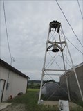 view gallery view galleryE24.8 km |  Meagher County Fire Department Bell Tower - White Sulphur Springs, Montana Meagher County Fire Department Bell Tower - White Sulphur Springs, Montana
in Bell Towers Meagher County Fire Department bell tower is between the two fire department buildings, located near the White Sulphur Spring town hall on the NW side of downtown on W. Hampton Street. posted by: T0SHEA location: Montana date approved: 09/19/2018 last visited: never |
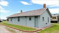
 view gallery view galleryE24.8 km |  (Meagher County Fire Department) White Sulphur Springs, Montana (Meagher County Fire Department) White Sulphur Springs, Montana
in Firehouses (Meagher County Fire Department) has no name on the building and is located next to White Sulphur Spring town hall on the NW side of downtown. posted by: T0SHEA location: Montana date approved: 09/21/2018 last visited: never |
 view gallery view galleryE24.8 km |  Meagher County Fire Department Siren - White Sulphur Springs, Montana Meagher County Fire Department Siren - White Sulphur Springs, Montana
in Outdoor Warning Sirens Meagher County Fire Department bell is between the two fire department buildings, located near the White Sulphur Spring town hall on the NW side of downtown on W. Hampton Street. posted by: T0SHEA location: Montana date approved: 09/21/2018 last visited: never |
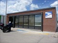 view gallery view galleryE24.8 km |  White Sulphur Springs, Mt 59645 White Sulphur Springs, Mt 59645
in U.S. Post Offices Located at 103 W Main St White Sulphur Springs, MT 59645 posted by: nomadwillie location: Montana date approved: 04/30/2012 last visited: never |
 view gallery view galleryE24.8 km |  Meagher County Courthouse - 1952 - White Sulphur Springs, MT Meagher County Courthouse - 1952 - White Sulphur Springs, MT
in Dated Architectural Structures Multifarious Not built until 1952, it's highly unlikely that this is the first Meagher County Courthouse. posted by: T0SHEA location: Montana date approved: 01/01/2023 last visited: never |
 view gallery view galleryE24.8 km |  Meagher County Courthouse - White Sulphur Springs, MT Meagher County Courthouse - White Sulphur Springs, MT
in Courthouses Not built until 1952, it's highly unlikely that this is the first Meagher County Courthouse. posted by: T0SHEA location: Montana date approved: 01/13/2023 last visited: never |
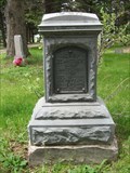
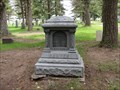 view gallery view galleryE24.9 km |  Margaret Sarter - Mayn Cemetery - White Sulphur Springs, Montana Margaret Sarter - Mayn Cemetery - White Sulphur Springs, Montana
in Zinc Headstones Mayn Cemetery is east of White Sulphur Springs on Cemetery Road, off Hwy. 89. posted by: T0SHEA location: Montana date approved: 07/02/2023 last visited: never |
 view gallery view galleryE24.9 km | Henry Zehntner - Mayn Cemetery - White Sulphur Springs, Montana in Zinc Headstones Mayn Cemetery is east of White Sulphur Springs on Cemetery Road, off Hwy. 89. posted by: T0SHEA location: Montana date approved: 08/23/2023 last visited: never |
 view gallery view galleryE24.9 km |  Union League of America Hall - White Sulphur Springs, MT Union League of America Hall - White Sulphur Springs, MT
in U.S. National Register of Historic Places First a Union League of America Hall, then an Independent Order of Good Templars hall, this building lived the majority of its life as a Presbyterian Church. posted by: T0SHEA location: Montana date approved: 09/20/2017 last visited: never |
 view gallery view galleryE24.9 km |  Union League of America Hall - White Sulphur Springs, MT Union League of America Hall - White Sulphur Springs, MT
in Wikipedia Entries First a Union League of America Hall, then an Independent Order of Good Templars hall, this building lived the majority of its life as a Presbyterian Church. posted by: T0SHEA location: Montana date approved: 09/19/2017 last visited: never |
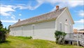
 view gallery view galleryE24.9 km |  Union League of America Hall - White Sulphur Springs, MT Union League of America Hall - White Sulphur Springs, MT
in Relocated Structures Built in the gold rush town of Diamond City, first a Union League of America Hall, then an Independent Order of Good Templars hall, this building lived the majority of its life as a Presbyterian Church. posted by: T0SHEA location: Montana date approved: 09/19/2017 last visited: never |
 view gallery view galleryE24.9 km |  ONLY - Remaining Remnant of Diamond City, MT ONLY - Remaining Remnant of Diamond City, MT
in Superlatives First a Union League of America Hall, then an Independent Order of Good Templars hall, then a Presbyterian Church, today it is the only known building remaining from the once thriving gold rush town of Diamond City. posted by: T0SHEA location: Montana date approved: 09/19/2017 last visited: never |
 view gallery view galleryE24.9 km |  Former Presbyterian Church - White Sulphur Springs, MT Former Presbyterian Church - White Sulphur Springs, MT
in Presbyterian Churches First a Union League of America Hall, then an Independent Order of Good Templars hall, this building lived the majority of its life as a Presbyterian Church. posted by: T0SHEA location: Montana date approved: 09/19/2017 last visited: never |
 view gallery view galleryE24.9 km |  ONLY - Remaining Remnant of Diamond City, MT ONLY - Remaining Remnant of Diamond City, MT
in Lucky 7 First a Union League of America Hall, then an Independent Order of Good Templars hall, then a Presbyterian Church, today it is the only known building remaining from the once thriving gold rush town of Diamond City. posted by: T0SHEA location: Montana date approved: 03/02/2018 last visited: never |
|