 view gallery view gallery E0 km E0 km
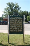
|   New Fort Brady New Fort Brady
in Michigan Historical Markers The New Fort Brady Marker is located on the Campus of Lake Superior State University. posted by:  Jagman714 Jagman714 location: Michigan date approved: 07/12/2009 last visited: 03/06/2023 |
 view gallery view gallery SW0.3 km SW0.3 km
| Lake Superior State College in Michigan Historical Markers The Lake Superior State College marker is located on the campus of Lake Superior State University posted by: Jagman714 location: Michigan date approved: 07/12/2009 last visited: 01/05/2023 |
 view gallery view gallery N1 km N1 km
|  USA to Canada - I-75 - Sault Ste Marie, Michigan. USA to Canada - I-75 - Sault Ste Marie, Michigan.
in Border Crossings International border crossing using the I-75 across the 'International Bridge' over St. Marys River and the Soo Locks, between the twin cities of Sault Ste Marie, Michigan, USA and Sault Ste. Marie, Ontario, Canada. posted by:  veritas vita veritas vita location: Michigan date approved: 06/11/2012 last visited: 08/09/2020 |
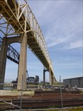 view gallery view galleryN1 km |  Sault Ste Marie - International Bridge - Michigan, USA. Sault Ste Marie - International Bridge - Michigan, USA.
in Wikipedia Entries International border crossing using the I-75 road across the 'International Road Bridge' over St. Marys River and the Soo Locks, between the twin cities of Sault Ste Marie, Michigan, USA and Sault Ste. Marie, Ontario, Canada. posted by: veritas vita location: Michigan date approved: 01/20/2013 last visited: 08/09/2020 |
 view gallery view galleryN1 km |  International Road Bridge - USA/Canada - Sault Ste Marie, Michigan International Road Bridge - USA/Canada - Sault Ste Marie, Michigan
in Satellite Imagery Oddities International border crossing using the I-75 road across the 'International Road Bridge' over St. Marys River and the Soo Locks, between the twin cities of Sault Ste Marie, Michigan, USA and Sault Ste. Marie, Ontario, Canada. posted by: veritas vita location: Michigan date approved: 01/21/2013 last visited: 08/09/2020 |
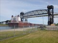 view gallery view galleryN1 km |  International Railway Bridge - Sault Ste Marie - Michigan - USA. International Railway Bridge - Sault Ste Marie - Michigan - USA.
in Railroad Bridges A single track, combination series of bridges including a vertical lift railroad bridge, double bascule bridge, and swing bridge, over the St. Marys River and Soo Locks, between Sault Ste Marie, Michigan, USA and Sault Ste. Marie, Ontario, Canada. posted by: veritas vita location: Michigan date approved: 06/08/2012 last visited: 08/09/2020 |
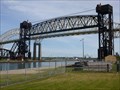 view gallery view galleryN1 km |  International Bridge - Sault Ste Marie - Michigan - USA. International Bridge - Sault Ste Marie - Michigan - USA.
in Vertical Lift Bridges A vertical lift railroad bridge, part of the International Bridge over the St. Marys River between Sault Ste Marie, Michigan, USA and the twin city of Sault Ste. Marie, Ontario, Canada. posted by: veritas vita location: Michigan date approved: 10/16/2012 last visited: 01/19/2022 |
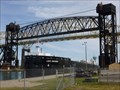 view gallery view galleryN1 km | International Bridge - Sault Ste Marie - Michigan - USA. in Moving Bridges A vertical lift railroad bridge, double bascule bridge, and swing bridge, over the St. Marys River between Sault Ste Marie, Michigan, USA and Sault Ste. Marie, Ontario, Canada. posted by: veritas vita location: Michigan date approved: 06/08/2012 last visited: 01/19/2022 |
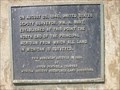 view gallery view galleryN1 km |  Principal Meridian - Sault Ste. Marie - Michigan, USA. Principal Meridian - Sault Ste. Marie - Michigan, USA.
in U.S. Historic Survey Stones and Monuments A plaque dated August 25, 1840. marking the point from which all land in Michigan is surveyed. Located at Sault Ste. Marie, Upper Peninsula, Michigan. posted by: veritas vita location: Michigan date approved: 01/09/2013 last visited: 12/19/2016 |
 view gallery view galleryE1.1 km |  St. George Greek Orthodox Church - Sault Ste. Marie, MI St. George Greek Orthodox Church - Sault Ste. Marie, MI
in Orthodox Churches Greek Orthodox Church located in the town made famous by the Soo Locks. posted by: linkys location: Michigan date approved: 08/13/2011 last visited: 05/27/2012 |
 view gallery view gallery NE1.1 km NE1.1 km
|  Herbert J Taylor - Sault Ste Marie - Michigan. Herbert J Taylor - Sault Ste Marie - Michigan.
in Rotary International Markers In the early 1940's The 4-Way Test was adopted by Rotary International. The Author of the 'Four Way Test' was Herbert J. Taylor, born in Pickford, Michigan. posted by: veritas vita location: Michigan date approved: 05/27/2012 last visited: 05/16/2019 |
 view gallery view galleryNE1.1 km |  Herbert J Taylor - Sault Ste Marie - Michigan. Herbert J Taylor - Sault Ste Marie - Michigan.
in Statues of Historic Figures In the early 1940's The 4-Way Test was adopted by Rotary International. The 4-Way Test Association was later founded by its author, Herbert J. Taylor. posted by: veritas vita location: Michigan date approved: 05/27/2012 last visited: 05/16/2019 |
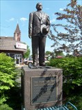 view gallery view galleryNE1.1 km |  The 4-Way Test - Dixie Hwy - Sault Ste Marie - Michigan. The 4-Way Test - Dixie Hwy - Sault Ste Marie - Michigan.
in Dixie Highway The Four-Way Test was adopted by Rotary International in the 1940s the author was Herbert J. Taylor, who was born 1893 in Pickford alongside the Dixie Hwy, and his monument now stands on the Dixie Highway / Ashmun street, Sault Ste Marie, Michigan. posted by: veritas vita location: Michigan date approved: 06/09/2012 last visited: 05/16/2019 |
 view gallery view galleryNE1.1 km |  Great Lakes Shipwreck Hitorical Society- Sault Ste. Marie MI Great Lakes Shipwreck Hitorical Society- Sault Ste. Marie MI
in Historical Society Headquarters Home to the Great Lakes Shipwreck Historical Society, the building was used as the US Weather Bureau Builiding. posted by: nomadwillie location: Michigan date approved: 10/23/2015 last visited: 07/09/2019 |
 view gallery view galleryNE1.1 km |  Great Lakes Shipwreck Museum - Sault Ste. Marie MI Great Lakes Shipwreck Museum - Sault Ste. Marie MI
in Maritime Museums Home to the Great Lakes Shipwreck Historical Society, the building was used as the US Weather Bureau Builiding. posted by: nomadwillie location: Michigan date approved: 10/23/2015 last visited: 07/09/2019 |
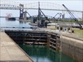
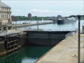 view gallery view galleryNE1.1 km | Largest Lock in the USA - Sault Saint Marie - Michigan. in Satellite Imagery Oddities Soo locks are a set of parallel locks which enable ships to travel between Lake Superior and the lower Great Lakes. They are located on the St. Marys River between the Upper Peninsula of the US state of Michigan and the Canadian province of Ontario. posted by: veritas vita location: Michigan date approved: 01/22/2013 last visited: 06/30/2019 |
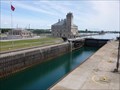 view gallery view galleryNE1.1 km |  Soo Locks - Sault Saint Marie - Michigan, USA. Soo Locks - Sault Saint Marie - Michigan, USA.
in Official Local Tourism Attractions Soo locks are a set of parallel locks which enable ships to travel between Lake Superior and the lower Great Lakes. They are located on the St. Marys River between the Upper Peninsula of the US state of Michigan and the Canadian province of Ontario. posted by: veritas vita location: Michigan date approved: 09/10/2012 last visited: 07/11/2018 |
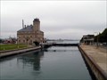
 view gallery view galleryNE1.1 km | St. Marys River (Michigan–Ontario) in Wikipedia Entries The St. Marys River drains Lake Superior, starting at the end of Whitefish Bay and flowing 75 miles southeast into Lake Huron, For its entire length it is an international border, separating Michigan in the United States from Ontario, Canada. posted by: veritas vita location: Michigan date approved: 09/10/2012 last visited: 07/11/2018 |
 view gallery view galleryNE1.1 km | Soo Locks - Sault Saint Marie - Michigan, USA. in Wikipedia Entries Soo locks are a set of parallel locks which enable ships to travel between Lake Superior and the lower Great Lakes. They are located on the St. Marys River between the Upper Peninsula of the US state of Michigan and the Canadian province of Ontario. posted by: veritas vita location: Michigan date approved: 09/10/2012 last visited: 07/11/2018 |
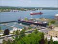
 view gallery view galleryNE1.1 km |  Soo Locks, Sault Saint Marie MI/Ont Soo Locks, Sault Saint Marie MI/Ont
in Waterway Locks, Planes and Lifts The locks that bypass the rapids of the St. Mary's River connecting Lake Superior to Lake Huron. posted by: S5280ft location: Michigan date approved: 08/26/2007 last visited: 06/26/2016 |
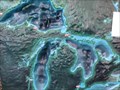 view gallery view galleryNE1.1 km |  3D Map - Great Lakes - Sault St Marie - Michigan, USA. 3D Map - Great Lakes - Sault St Marie - Michigan, USA.
in 3D Map Models of Our World and Beyond The 3D model of the Great Lakes is located in the Soo Locks Visitor centre. The locks bypass the rapids of the St. Mary's River connecting Lake Superior to Lake Huron. posted by: veritas vita location: Michigan date approved: 05/26/2013 last visited: 06/01/2013 |
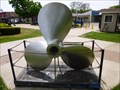 view gallery view galleryNE1.1 km |  Marquette Propeller - Soo Locks - Sault Ste Marie. Marquette Propeller - Soo Locks - Sault Ste Marie.
in Maritime Monuments and Memorials Propeller from the tug 'Marquette' built in New Orleans, Louisiana, in 1942. The Marquette's home port was Duluth, Minnesota. Now located at Soo Locks, Sault Ste Marie, Michigan. posted by: veritas vita location: Michigan date approved: 06/10/2012 last visited: 07/15/2019 |
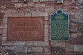 view gallery view galleryE1.1 km | Central Methodist Church in Michigan Historical Markers The Central Methodist Church marker is located at 111 East Spruce St.
Sault Ste. Marie. posted by: Jagman714 location: Michigan date approved: 07/12/2009 last visited: 01/04/2023 |
 view gallery view galleryE1.1 km | Central Methodist Episcopal Church (Sault Ste. Marie, Michigan) USA. in Wikipedia Entries Central Methodist Episcopal Church (now the Central United Methodist Church) is a historic church in Sault Ste. Marie, Michigan. It was listed on the National Register of Historic Places in 1984. posted by: veritas vita location: Michigan date approved: 09/10/2012 last visited: 03/06/2023 |
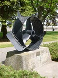 view gallery view galleryNE1.1 km | Independence Propeller - Soo Locks - Sault Ste Marie, USA. in Maritime Monuments and Memorials Propeller from the 'Independence' The first steamship to ply trade on Lake superior, Also a memorial to the four people who lost their lives when she sank at sea. Located at Soo Locks, Sault Ste Marie, Michigan, USA. posted by: veritas vita location: Michigan date approved: 06/10/2012 last visited: 07/09/2019 |
|