 view gallery view gallery N1.6 km N1.6 km
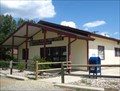
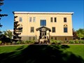
|   Clancy, MT - 59634 Clancy, MT - 59634
in U.S. Post Offices This Post Office serves the community of Clancy and surrounding area. posted by:  CerealBoxMonsters CerealBoxMonsters location: Montana date approved: 08/09/2010 last visited: 06/14/2014 |
 view gallery view gallery SW5.5 km SW5.5 km
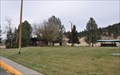
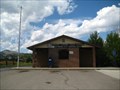
|  Interstate 15 Northbound Jefferson City Rest Area Interstate 15 Northbound Jefferson City Rest Area
in Highway Rest Areas The Montana Department of Transportation Jefferson City Rest Area is located on the east side of Interstate 15 just north of Jefferson City, Montana. posted by:  brwhiz brwhiz location: Montana date approved: 10/17/2012 last visited: never |
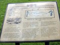
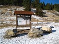
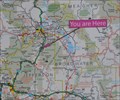 view gallery view gallerySW5.5 km |  Interstate 15 Jefferson City Rest Area Interstate 15 Jefferson City Rest Area
in 'You Are Here' Maps You Are Here at the Jefferson City Rest Area on the east side of Interstate 15 just north of Jefferson City, Montana. posted by: brwhiz location: Montana date approved: 10/17/2012 last visited: never |
 view gallery view gallery NE5.5 km NE5.5 km
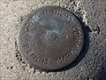
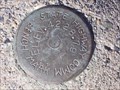
|  Interstate 15 South Benchmark Interstate 15 South Benchmark
in U.S. Benchmarks This is a State Highway Commission benchmark located just off of Interstate 15 South. posted by: skeezicks location: Montana date approved: 10/27/2007 last visited: never |
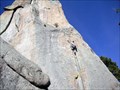 view gallery view gallery NW6 km NW6 km
|  Sheep Mountain - Clancy, MT Sheep Mountain - Clancy, MT
in Established Rock Climbing Areas A good area for a variety of rock climbing abilities. Great views of the Elkhorn Mountains. posted by: CerealBoxMonsters location: Montana date approved: 04/22/2010 last visited: never |
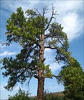 view gallery view galleryNE6.8 km |  The Hanging Tree - Clancy, MT The Hanging Tree - Clancy, MT
in Best Kept Secrets Thousands of people drive by this tree everyday, but very few are aware that it bore witness to dozens of hangings in the late 1800's. Upon close inspection, you can still see where the ropes wore marks into the branches. posted by: CerealBoxMonsters location: Montana date approved: 09/20/2010 last visited: 10/08/2017 |
 view gallery view gallerySW7.6 km | Jefferson City, MT - 59638 in U.S. Post Offices This Post Office serves the community of Jefferson City and the surrounding area. posted by: CerealBoxMonsters location: Montana date approved: 08/09/2010 last visited: 09/21/2016 |
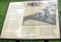
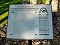
 view gallery view galleryN12.2 km |  Construction of the Northern Pacific Railroad, Gold Creek, MT Construction of the Northern Pacific Railroad, Gold Creek, MT
in Montana Historical Markers The Gold Creek Rest Area off of I-90, eastbound, has four signs posted by the Powell County Museum and Arts Foundation, including this one. posted by: Queens Blessing location: Montana date approved: 10/17/2010 last visited: 09/15/2012 |
 view gallery view galleryN12.2 km | The Northern Pacific Railroad, Gold Creek, MT in Montana Historical Markers This is one of four signs posted in the Gold Creek Rest Area by the Powell County Museum and Arts Foundation. posted by: Queens Blessing location: Montana date approved: 10/16/2010 last visited: 09/15/2012 |
 view gallery view galleryN12.6 km | Highway 282/South Hills Road Intersection Benchmark in U.S. Benchmarks A State Highway Commission benchmark just south of Helena,Montana. posted by: skeezicks location: Montana date approved: 04/03/2008 last visited: never |
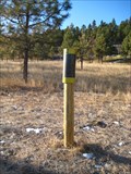
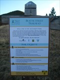
 view gallery view galleryN13.4 km |  Rodney Ridge Trail - Old Shooting Range Trailhead - Helena, MT Rodney Ridge Trail - Old Shooting Range Trailhead - Helena, MT
in Hiking and walking trailheads Rodney Ridge provides numerous trails; some maintained by local hiking groups, and others by the USFS. The Old Shooting Range Trailhead provides a great start to many of these trails. posted by: CerealBoxMonsters location: Montana date approved: 11/21/2009 last visited: 05/01/2012 |
 view gallery view galleryN13.5 km |  South Hills Disc Golf Course - Helena, MT South Hills Disc Golf Course - Helena, MT
in Disc Golf Courses An 18-hole course with wooden tone posts. This is the newest course in Helena and is free to anyone who would like to play. UPDATE ** As of summer 2010 holes have been replaced with metal chain-drop baskets and concrete pads placed at tees! ** posted by: CerealBoxMonsters location: Montana date approved: 11/19/2009 last visited: 06/20/2014 |
 view gallery view galleryN14.5 km | South Hills Trails System - Beattie St. - Helena, MT in Hiking and walking trailheads This trailhead provides the most accessible route to the South Hills Trail system in town. posted by: CerealBoxMonsters location: Montana date approved: 11/18/2009 last visited: never |
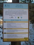 view gallery view galleryN14.6 km | South Hills Trails System - DeFord Trail - Helena, MT in Hiking and walking trailheads Known locally as the "woodchip trail," this wide and forgiving pathway along Davis/Dry Gulch Rd provides access to the South Hills Trail System, as well as the Rodney Ridge Trails. posted by: CerealBoxMonsters location: Montana date approved: 11/21/2009 last visited: 05/17/2012 |
 view gallery view galleryN14.8 km |  CerealBoxMonster's Geocaching Blog CerealBoxMonster's Geocaching Blog
in Bloggers Just a personal geocaching/waymarking and adventure blog. posted by: CerealBoxMonsters location: Montana date approved: 11/02/2009 last visited: 11/03/2023 |
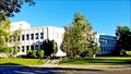
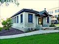
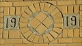 view gallery view galleryN15.1 km |  1919 - Board of Health Building - Helena, MT 1919 - Board of Health Building - Helena, MT
in Dated Buildings and Cornerstones Built in 1919-1920, the old Board of Health Building was the second building on the campus to house a government department outside the capitol building. posted by: T0SHEA location: Montana date approved: 09/01/2017 last visited: never |
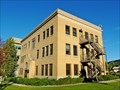 view gallery view galleryN15.1 km |  Board of Health Building - Montana State Capitol Campus Historic District - Helena, MT Board of Health Building - Montana State Capitol Campus Historic District - Helena, MT
in NRHP Historic Districts - Contributing Buildings Built in 1919-1920, the old Board of Health Building was the second building on the campus to house a government department outside the capitol building. posted by: T0SHEA location: Montana date approved: 09/05/2017 last visited: never |
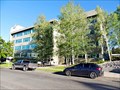
 view gallery view galleryN15.1 km | Cogswell Building - Montana State Capitol Campus Historic District - Helena, MT in NRHP Historic Districts - Contributing Buildings Essentially occupying a full city block, the Cogswell Building was built in two stages, the original section in 1954-55, with an addition in 1981. posted by: T0SHEA location: Montana date approved: 09/07/2017 last visited: never |
 view gallery view galleryN15.1 km |  W.F. Cogswell Building - Helena, MT W.F. Cogswell Building - Helena, MT
in People-Named Places Essentially occupying a full city block, the Cogswell Building was built in two stages, the original section in 1954-55, with an addition in 1981. posted by: T0SHEA location: Montana date approved: 09/07/2017 last visited: never |
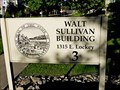 view gallery view galleryN15.1 km | Walt Sullivan Building - Helena, MT in People-Named Places The Unemployment Compensation Commission Building (Walt Sullivan Building), built in 1959-1961, stands on the southwest corner of North Roberts Street and Lockey Avenue, one of several buildings built on the Capitol Campus in this era. posted by: T0SHEA location: Montana date approved: 09/10/2017 last visited: never |
 view gallery view galleryN15.1 km | Unemployment Compensation Commission - Helena, MT in Montana Historical Markers The Unemployment Compensation Commission Building (Walt Sullivan Building), built in 1959-1961, stands on the southwest corner of North Roberts Street and Lockey Avenue, one of several buildings built on the Capitol Campus in this era. posted by: T0SHEA location: Montana date approved: 09/10/2017 last visited: never |
 view gallery view galleryN15.1 km |  Unemployment Compensation Commission - Helena, MT Unemployment Compensation Commission - Helena, MT
in U.S. National Register of Historic Places The Unemployment Compensation Commission Building (Walt Sullivan Building), built in 1959-1961, stands on the southwest corner of North Roberts Street and Lockey Avenue, one of several buildings built on the Capitol Campus in this era. posted by: T0SHEA location: Montana date approved: 09/10/2017 last visited: never |
 view gallery view galleryN15.1 km | Livestock Building - Montana State Capitol Campus Historic District - Helena, MT in NRHP Historic Districts - Contributing Buildings Built in 1918, the old Livestock Building, as opposed to the new Livestock Building, was the first building on the campus to house a government department outside the capitol building. posted by: T0SHEA location: Montana date approved: 09/05/2017 last visited: never |
 view gallery view galleryN15.1 km | Legislative Restaurant / Capitol Annex - Montana State Capitol Campus Historic District - Helena, MT in NRHP Historic Districts - Contributing Buildings Built in 1910, this was the second building to appear in the Montana State Capitol Campus Historic District, eight years after the completion of the capitol building. posted by: T0SHEA location: Montana date approved: 09/05/2017 last visited: never |
 view gallery view galleryN15.1 km | Sam W. Mitchell Building - Helena, MT in People-Named Places The State Office Building (Sam W. Mitchell Building) was one of three large office buildings to be constructed in the campus complex in the 1950s as government departments grew in size and grew in number. posted by: T0SHEA location: Montana date approved: 09/02/2017 last visited: never |
|