 view gallery view gallery W13.7 km W13.7 km
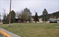
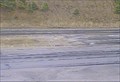
|   Interstate 15 Northbound Jefferson City Rest Area Interstate 15 Northbound Jefferson City Rest Area
in Highway Rest Areas The Montana Department of Transportation Jefferson City Rest Area is located on the east side of Interstate 15 just north of Jefferson City, Montana. posted by:  brwhiz brwhiz location: Montana date approved: 10/17/2012 last visited: never |
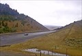
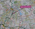 view gallery view galleryW13.7 km |  Interstate 15 Jefferson City Rest Area Interstate 15 Jefferson City Rest Area
in 'You Are Here' Maps You Are Here at the Jefferson City Rest Area on the east side of Interstate 15 just north of Jefferson City, Montana. posted by: brwhiz location: Montana date approved: 10/17/2012 last visited: never |
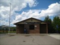 view gallery view galleryW14.3 km |  Jefferson City, MT - 59638 Jefferson City, MT - 59638
in U.S. Post Offices This Post Office serves the community of Jefferson City and the surrounding area. posted by:  CerealBoxMonsters CerealBoxMonsters location: Montana date approved: 08/09/2010 last visited: 09/21/2016 |
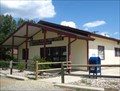 view gallery view gallery NW15 km NW15 km
| Clancy, MT - 59634 in U.S. Post Offices This Post Office serves the community of Clancy and surrounding area. posted by: CerealBoxMonsters location: Montana date approved: 08/09/2010 last visited: 06/14/2014 |
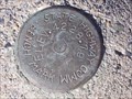
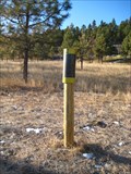
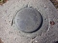
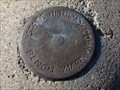 view gallery view galleryNW16.3 km |  Interstate 15 South Benchmark Interstate 15 South Benchmark
in U.S. Benchmarks This is a State Highway Commission benchmark located just off of Interstate 15 South. posted by: skeezicks location: Montana date approved: 10/27/2007 last visited: never |
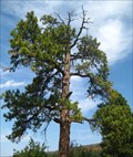 view gallery view galleryNW16.9 km |  The Hanging Tree - Clancy, MT The Hanging Tree - Clancy, MT
in Best Kept Secrets Thousands of people drive by this tree everyday, but very few are aware that it bore witness to dozens of hangings in the late 1800's. Upon close inspection, you can still see where the ropes wore marks into the branches. posted by: CerealBoxMonsters location: Montana date approved: 09/20/2010 last visited: 10/08/2017 |
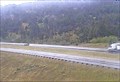
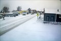
 view gallery view galleryW18.2 km |  Boulder Hill North Webcam - Boulder, MT Boulder Hill North Webcam - Boulder, MT
in Web Cameras This is one of 73 (as of January 2017) Road Weather Information System cameras operated by the Montana Department of Transportation to aid motorists as they make their way across BIG SKY Country. posted by: T0SHEA location: Montana date approved: 01/10/2017 last visited: never |
 view gallery view galleryW18.3 km | Boulder Hill Northeast Webcam - Boulder, MT in Web Cameras This is one of 73 (as of January 2017) Road Weather Information System cameras operated by the Montana Department of Transportation to aid motorists as they make their way across BIG SKY Country. posted by: T0SHEA location: Montana date approved: 01/10/2017 last visited: never |
 view gallery view galleryW18.3 km | Boulder Hill Roadway Webcam - Boulder, MT in Web Cameras This is one of 73 (as of January 2017) Road Weather Information System cameras operated by the Montana Department of Transportation to aid motorists as they make their way across BIG SKY Country. posted by: T0SHEA location: Montana date approved: 01/10/2017 last visited: never |
 view gallery view galleryW18.5 km | Boulder Hill Southeast Webcam - Boulder, MT in Web Cameras This is one of 73 (as of January 2017) Road Weather Information System cameras operated by the Montana Department of Transportation to aid motorists as they make their way across BIG SKY Country. posted by: T0SHEA location: Montana date approved: 01/10/2017 last visited: never |
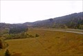
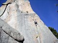 view gallery view galleryNW19.6 km |  Sheep Mountain - Clancy, MT Sheep Mountain - Clancy, MT
in Established Rock Climbing Areas A good area for a variety of rock climbing abilities. Great views of the Elkhorn Mountains. posted by: CerealBoxMonsters location: Montana date approved: 04/22/2010 last visited: never |
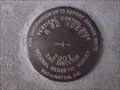
 view gallery view galleryNW22.7 km | Highway 282/South Hills Road Intersection Benchmark in U.S. Benchmarks A State Highway Commission benchmark just south of Helena,Montana. posted by: skeezicks location: Montana date approved: 04/03/2008 last visited: never |
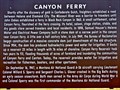 view gallery view gallery E22.9 km E22.9 km
|  Canyon Ferry - Townsend, MT Canyon Ferry - Townsend, MT
in Montana Historical Markers Just over 2 miles north of Townsend on Highway 12/287, this Montana Historical Highway Marker stands at a large pullout on the east side of the highway. It overlooks Canyon Ferry Reservoir to the east. posted by: T0SHEA location: Montana date approved: 08/06/2017 last visited: never |
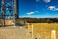 view gallery view gallery SW23.8 km SW23.8 km
|  Boulder Mountain Repeater Boulder Mountain Repeater
in Amateur Radio Repeaters The Boulder Mountain Repeater is housed in a former AT&T transmitter building on top of Boulder Mountain in Jefferson County, Montana. posted by: mtbearded1 location: Montana date approved: 07/22/2020 last visited: never |
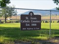 view gallery view gallery N24 km N24 km
|  St. Ann's Cemetery - East Helena, Montana St. Ann's Cemetery - East Helena, Montana
in Worldwide Cemeteries St. Ann's Cemetery is next to Bighorn Sales and Rentals on Hwy. 12 in East Helena. posted by: T0SHEA location: Montana date approved: 01/17/2018 last visited: never |
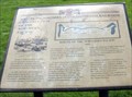 view gallery view galleryNW24 km | Construction of the Northern Pacific Railroad, Gold Creek, MT in Montana Historical Markers The Gold Creek Rest Area off of I-90, eastbound, has four signs posted by the Powell County Museum and Arts Foundation, including this one. posted by: Queens Blessing location: Montana date approved: 10/17/2010 last visited: 09/15/2012 |
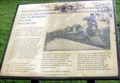 view gallery view galleryNW24 km | The Northern Pacific Railroad, Gold Creek, MT in Montana Historical Markers This is one of four signs posted in the Gold Creek Rest Area by the Powell County Museum and Arts Foundation. posted by: Queens Blessing location: Montana date approved: 10/16/2010 last visited: 09/15/2012 |
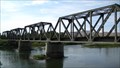 view gallery view galleryE24.1 km |  Missouri River Train Truss Bridge - Townsend, MT Missouri River Train Truss Bridge - Townsend, MT
in Truss Bridges A large steel train truss bridge that crosses the Missouri River near Townsend, MT. This bridge sees east- and west-bound trains everyday of the year. posted by: CerealBoxMonsters location: Montana date approved: 10/02/2009 last visited: never |
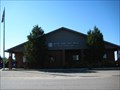 view gallery view galleryN24.1 km | East Helena, MT 59635 in U.S. Post Offices This Post Office serves the town of East Helena and surrounding community, of approximately 3000 people. posted by: CerealBoxMonsters location: Montana date approved: 10/05/2009 last visited: 04/15/2017 |
 view gallery view galleryNW24.5 km |  South Hills Disc Golf Course - Helena, MT South Hills Disc Golf Course - Helena, MT
in Disc Golf Courses An 18-hole course with wooden tone posts. This is the newest course in Helena and is free to anyone who would like to play. UPDATE ** As of summer 2010 holes have been replaced with metal chain-drop baskets and concrete pads placed at tees! ** posted by: CerealBoxMonsters location: Montana date approved: 11/19/2009 last visited: 06/20/2014 |
 view gallery view galleryN24.5 km | Asarco Area Benchmark in U.S. Benchmarks A State Hwy. Comm. benchmark near the Asarco smelter in East Helena. posted by: skeezicks location: Montana date approved: 10/04/2007 last visited: 05/15/2012 |
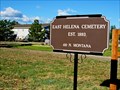 view gallery view galleryN24.9 km |  East Helena Cemetery - 1893 - East Helena, Montana East Helena Cemetery - 1893 - East Helena, Montana
in Dated Architectural Structures Multifarious East Helena Cemetery North of downtown at 401 N. Montana Avenue. posted by: T0SHEA location: Montana date approved: 01/20/2018 last visited: never |
 view gallery view galleryN24.9 km | East Helena Cemetery - East Helena, Montana in Worldwide Cemeteries East Helena Cemetery North of downtown on N. Montana Avenue. posted by: T0SHEA location: Montana date approved: 01/18/2018 last visited: never |
 view gallery view galleryE25.4 km | Broadwater School And Community Library Vertical Control Mark in U.S. Benchmarks This is a vertical control mark located at the Broadwater School And Community Library in Townsend,Montana. posted by: skeezicks location: Montana date approved: 10/20/2007 last visited: 04/30/2010 |
 view gallery view galleryE25.4 km | Town Hall Camera - Townsend, MT in Web Cameras In townsend, if one finds this webcam they have found town hall. posted by: T0SHEA location: Montana date approved: 03/03/2019 last visited: never |
|