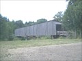
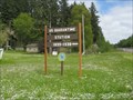
 view gallery view gallery E2.1 km E2.1 km
|   Grays River Covered Bridge Grays River Covered Bridge
in Washington Historical Markers The only covered bridge in Washington that is still in use. posted by:  Prying Pandora Prying Pandora location: Washington date approved: 07/22/2006 last visited: 03/16/2024 |
 view gallery view galleryE2.1 km |  Grays River Covered Bridge Grays River Covered Bridge
in U.S. National Register of Historic Places The only covered bridge in Washington that is still in use. posted by: Prying Pandora location: Washington date approved: 05/02/2007 last visited: 03/16/2024 |
 view gallery view galleryE2.1 km |  Grays River Covered Bridge Grays River Covered Bridge
in Covered Bridges The only covered bridge in Washington that is still in use. posted by: Prying Pandora location: Washington date approved: 06/10/2007 last visited: 03/16/2024 |
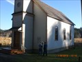
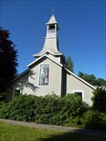
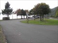
 view gallery view gallery W5.6 km W5.6 km
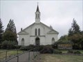
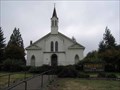
|  Holy Trinity Evangelical Lutheran Church - Naselle, Washington Holy Trinity Evangelical Lutheran Church - Naselle, Washington
in This Old Church Originally constructed as "Deep River Church", it was built by settlers to the area in 1898. posted by:  shadow101 shadow101 location: Washington date approved: 05/12/2012 last visited: 01/08/2012 |
 view gallery view galleryW5.6 km | Holy Trinity Evangelical Lutheran Church - Naselle, Washington in Country Churches This church was built by Finnish and Swedish immigrants in the 1890s. posted by: shadow101 location: Washington date approved: 05/13/2012 last visited: 01/08/2012 |
 view gallery view galleryW5.6 km | Holy Trinity Evangelical Lutheran Church - Naselle, Washington in Lutheran Churches This historic church was built as 'Deep River Church' in the late 1890s. posted by: shadow101 location: Washington date approved: 05/13/2012 last visited: 01/08/2012 |
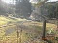 view gallery view galleryW5.8 km |  Deep River Cemetery - Naselle, Washington Deep River Cemetery - Naselle, Washington
in Worldwide Cemeteries On the hill above where the former town of Deep River stood. posted by: shadow101 location: Washington date approved: 05/14/2012 last visited: 01/08/2012 |
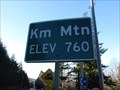 view gallery view galleryE7.7 km |  Km Mtn. - Grays River Washington - 760' Km Mtn. - Grays River Washington - 760'
in Elevation Signs The sign is located between Grays River and Skamokawa on Highway 4. posted by: WR7X location: Washington date approved: 01/26/2014 last visited: never |
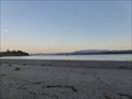 view gallery view gallery SE15 km SE15 km
|  Columbia River, Skamokawa, WA Columbia River, Skamokawa, WA
in Beaches This lovely beach is on the north shore of the Columbia River. posted by: gypsie2 location: Washington date approved: 09/14/2013 last visited: never |
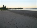 view gallery view gallerySE15 km |  Lewis and Clark Scenic Byway - WA Lewis and Clark Scenic Byway - WA
in National Scenic Byways Along the north shore of the Columbia River. posted by: gypsie2 location: Washington date approved: 10/11/2013 last visited: never |
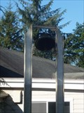 view gallery view gallerySE15 km |  Methodist Church Bell, Skamokawa, WA Methodist Church Bell, Skamokawa, WA
in Bells Church bell outside the tower. posted by: gypsie2 location: Washington date approved: 09/10/2013 last visited: never |
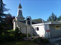 view gallery view gallerySE15 km |  Skamokawa United Methodist Church - Skamokawa, WA Skamokawa United Methodist Church - Skamokawa, WA
in Methodist Churches This small church is at the entrance to a county park. posted by: gypsie2 location: Washington date approved: 09/10/2013 last visited: never |
 view gallery view gallerySE15 km |  Window, Methodist Church, Skamokawa, WA Window, Methodist Church, Skamokawa, WA
in Stained Glass Windows Lovely window in small church. posted by: gypsie2 location: Washington date approved: 09/10/2013 last visited: never |
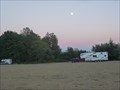 view gallery view gallerySE15 km |  Skamokawa County Park, Skamokawa, WA Skamokawa County Park, Skamokawa, WA
in Campgrounds Lovely spot to camp beside the Columbia River. posted by: gypsie2 location: Washington date approved: 09/13/2013 last visited: never |
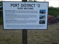 view gallery view gallerySE15 km |  River Watching - Skamokawa, WA River Watching - Skamokawa, WA
in Flora and Fauna Information Signs Marine mammals that you might see in the Columbia River. posted by: gypsie2 location: Washington date approved: 09/11/2013 last visited: never |
 view gallery view gallery SW19.5 km SW19.5 km
|  Knappton Cove Quarantine Center, Washington Knappton Cove Quarantine Center, Washington
in History Museums This is a hidden historical gem, located across the Columbia River from Astoria, Oregon. posted by: Queens Blessing location: Washington date approved: 07/08/2013 last visited: 09/02/2013 |
 view gallery view gallerySW19.5 km | Columbia River Quarantine Station, Knappton, WA in U.S. National Register of Historic Places Many have never heard of the "West Coast Ellis Island". posted by: Queens Blessing location: Washington date approved: 07/08/2013 last visited: 09/02/2013 |
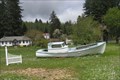 view gallery view gallerySW19.5 km |  Quarantine Boat, Chinook WA Quarantine Boat, Chinook WA
in Landlocked Boats Washington State is the location of a now closed quarantine center, similar to Ellis Island; it is also the location of a landlocked boat. posted by: Queens Blessing location: Washington date approved: 07/07/2013 last visited: 09/02/2013 |
 view gallery view gallery N22.2 km N22.2 km
| Holy Family Catholic Church, Frances, WA in Country Churches The Holy Family Catholic Church is located in the community of Frances, Washington and serves the central part of Willapa Valley. posted by: Volcanoguy location: Washington date approved: 11/28/2006 last visited: 12/03/2006 |
 view gallery view galleryN22.2 km | Holy Family Catholic Church, Frances, WA in This Old Church The Holy Family Catholic Church is located in the community of Frances, Washington and serves the central part of Willapa Valley. posted by: Volcanoguy location: Washington date approved: 11/28/2006 last visited: 11/28/2006 |
 view gallery view gallerySW22.5 km |  SC0997 - NGS K 531, Washington SC0997 - NGS K 531, Washington
in U.S. Benchmarks NGS PID SC0997 - NGS K 531 posted by: Volcanoguy location: Washington date approved: 02/25/2007 last visited: 02/25/2007 |
 view gallery view gallerySW22.5 km | “high waves & breakers” in Washington Historical Markers “high waves & breakers” sign at Washington State’s Dismal Nitch Safety Rest Area. posted by: Volcanoguy location: Washington date approved: 12/16/2006 last visited: 07/18/2009 |
 view gallery view gallerySW22.5 km | “best canoe navigators” in Washington Historical Markers “best canoe navigators” sign at Washington State’s Dismal Nitch Safety Rest Area. posted by: Volcanoguy location: Washington date approved: 12/16/2006 last visited: 07/18/2009 |
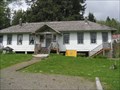
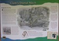 view gallery view gallerySW22.7 km |  Dismal Nitch, Washington Dismal Nitch, Washington
in Lewis and Clark Trail The Lewis & Clark Expedition spent six days near here waiting for a storm to let up so they could get around Point Ellice. posted by: Volcanoguy location: Washington date approved: 12/16/2006 last visited: 08/27/2013 |
 view gallery view gallerySW22.7 km |  Dismal Nitch Safety Rest Area, Washington Dismal Nitch Safety Rest Area, Washington
in Highway Rest Areas The Dismal Nitch Safety Rest Area on Wash. Hwy. 401. posted by: Volcanoguy location: Washington date approved: 12/16/2006 last visited: 06/23/2022 |
|