 view gallery view gallery SW2.6 km SW2.6 km
|   Boulder Hill North Webcam - Boulder, MT Boulder Hill North Webcam - Boulder, MT
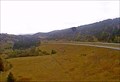
in Web Cameras This is one of 73 (as of January 2017) Road Weather Information System cameras operated by the Montana Department of Transportation to aid motorists as they make their way across BIG SKY Country. posted by:  T0SHEA T0SHEA location: Montana date approved: 01/10/2017 last visited: never |
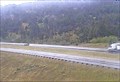 view gallery view gallerySW2.6 km | Boulder Hill Northeast Webcam - Boulder, MT in Web Cameras This is one of 73 (as of January 2017) Road Weather Information System cameras operated by the Montana Department of Transportation to aid motorists as they make their way across BIG SKY Country. posted by: T0SHEA location: Montana date approved: 01/10/2017 last visited: never |
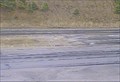 view gallery view gallerySW2.6 km | Boulder Hill Roadway Webcam - Boulder, MT in Web Cameras This is one of 73 (as of January 2017) Road Weather Information System cameras operated by the Montana Department of Transportation to aid motorists as they make their way across BIG SKY Country. posted by: T0SHEA location: Montana date approved: 01/10/2017 last visited: never |
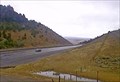 view gallery view gallerySW2.7 km | Boulder Hill Southeast Webcam - Boulder, MT in Web Cameras This is one of 73 (as of January 2017) Road Weather Information System cameras operated by the Montana Department of Transportation to aid motorists as they make their way across BIG SKY Country. posted by: T0SHEA location: Montana date approved: 01/10/2017 last visited: never |
 view gallery view gallery N5.5 km N5.5 km
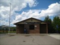
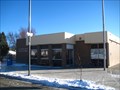
|  Jefferson City, MT - 59638 Jefferson City, MT - 59638
in U.S. Post Offices This Post Office serves the community of Jefferson City and the surrounding area. posted by:  CerealBoxMonsters CerealBoxMonsters location: Montana date approved: 08/09/2010 last visited: 09/21/2016 |
 view gallery view galleryN7.6 km |  Interstate 15 Northbound Jefferson City Rest Area Interstate 15 Northbound Jefferson City Rest Area
in Highway Rest Areas The Montana Department of Transportation Jefferson City Rest Area is located on the east side of Interstate 15 just north of Jefferson City, Montana. posted by: brwhiz location: Montana date approved: 10/17/2012 last visited: never |
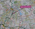 view gallery view galleryN7.6 km |  Interstate 15 Jefferson City Rest Area Interstate 15 Jefferson City Rest Area
in 'You Are Here' Maps You Are Here at the Jefferson City Rest Area on the east side of Interstate 15 just north of Jefferson City, Montana. posted by: brwhiz location: Montana date approved: 10/17/2012 last visited: never |
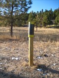
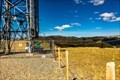 view gallery view gallerySW10.1 km |  Boulder Mountain Repeater Boulder Mountain Repeater
in Amateur Radio Repeaters The Boulder Mountain Repeater is housed in a former AT&T transmitter building on top of Boulder Mountain in Jefferson County, Montana. posted by: mtbearded1 location: Montana date approved: 07/22/2020 last visited: never |
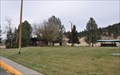
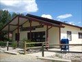
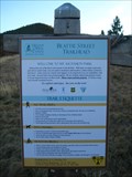
 view gallery view gallerySW13 km | Boulder, MT 59632 in U.S. Post Offices This Post Office serves the town of Boulder and its surrounding community of approximately 1,400 people.
posted by: CerealBoxMonsters location: Montana date approved: 12/13/2009 last visited: 09/21/2016 |
 view gallery view galleryN14.5 km | Clancy, MT - 59634 in U.S. Post Offices This Post Office serves the community of Clancy and surrounding area. posted by: CerealBoxMonsters location: Montana date approved: 08/09/2010 last visited: 06/14/2014 |
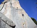 view gallery view galleryN17.2 km |  Sheep Mountain - Clancy, MT Sheep Mountain - Clancy, MT
in Established Rock Climbing Areas A good area for a variety of rock climbing abilities. Great views of the Elkhorn Mountains. posted by: CerealBoxMonsters location: Montana date approved: 04/22/2010 last visited: never |
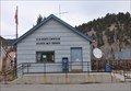 view gallery view gallerySW18.3 km | Basin, Montana 59631 in U.S. Post Offices This Post Office is located at 100 Basin Street in Basin, Montana. posted by: brwhiz location: Montana date approved: 11/22/2011 last visited: 04/14/2014 |
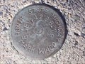
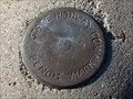 view gallery view galleryN18.5 km |  Interstate 15 South Benchmark Interstate 15 South Benchmark
in U.S. Benchmarks This is a State Highway Commission benchmark located just off of Interstate 15 South. posted by: skeezicks location: Montana date approved: 10/27/2007 last visited: never |
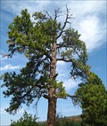 view gallery view gallery NE19.8 km NE19.8 km
|  The Hanging Tree - Clancy, MT The Hanging Tree - Clancy, MT
in Best Kept Secrets Thousands of people drive by this tree everyday, but very few are aware that it bore witness to dozens of hangings in the late 1800's. Upon close inspection, you can still see where the ropes wore marks into the branches. posted by: CerealBoxMonsters location: Montana date approved: 09/20/2010 last visited: 10/08/2017 |
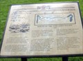 view gallery view galleryN24.6 km |  Construction of the Northern Pacific Railroad, Gold Creek, MT Construction of the Northern Pacific Railroad, Gold Creek, MT
in Montana Historical Markers The Gold Creek Rest Area off of I-90, eastbound, has four signs posted by the Powell County Museum and Arts Foundation, including this one. posted by: Queens Blessing location: Montana date approved: 10/17/2010 last visited: 09/15/2012 |
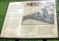 view gallery view galleryN24.6 km | The Northern Pacific Railroad, Gold Creek, MT in Montana Historical Markers This is one of four signs posted in the Gold Creek Rest Area by the Powell County Museum and Arts Foundation. posted by: Queens Blessing location: Montana date approved: 10/16/2010 last visited: 09/15/2012 |
 view gallery view galleryN24.6 km |  Rodney Ridge Trail - Old Shooting Range Trailhead - Helena, MT Rodney Ridge Trail - Old Shooting Range Trailhead - Helena, MT
in Hiking and walking trailheads Rodney Ridge provides numerous trails; some maintained by local hiking groups, and others by the USFS. The Old Shooting Range Trailhead provides a great start to many of these trails. posted by: CerealBoxMonsters location: Montana date approved: 11/21/2009 last visited: 05/01/2012 |
 view gallery view galleryN25.4 km | Highway 282/South Hills Road Intersection Benchmark in U.S. Benchmarks A State Highway Commission benchmark just south of Helena,Montana. posted by: skeezicks location: Montana date approved: 04/03/2008 last visited: never |
 view gallery view galleryN26.1 km |  South Hills Disc Golf Course - Helena, MT South Hills Disc Golf Course - Helena, MT
in Disc Golf Courses An 18-hole course with wooden tone posts. This is the newest course in Helena and is free to anyone who would like to play. UPDATE ** As of summer 2010 holes have been replaced with metal chain-drop baskets and concrete pads placed at tees! ** posted by: CerealBoxMonsters location: Montana date approved: 11/19/2009 last visited: 06/20/2014 |
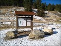
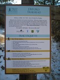 view gallery view galleryN26.1 km | South Hills Trails System - DeFord Trail - Helena, MT in Hiking and walking trailheads Known locally as the "woodchip trail," this wide and forgiving pathway along Davis/Dry Gulch Rd provides access to the South Hills Trail System, as well as the Rodney Ridge Trails. posted by: CerealBoxMonsters location: Montana date approved: 11/21/2009 last visited: 05/17/2012 |
 view gallery view galleryN26.2 km | South Hills Trails System - Beattie St. - Helena, MT in Hiking and walking trailheads This trailhead provides the most accessible route to the South Hills Trail system in town. posted by: CerealBoxMonsters location: Montana date approved: 11/18/2009 last visited: never |
 view gallery view galleryN26.6 km |  CerealBoxMonster's Geocaching Blog CerealBoxMonster's Geocaching Blog
in Bloggers Just a personal geocaching/waymarking and adventure blog. posted by: CerealBoxMonsters location: Montana date approved: 11/02/2009 last visited: 11/03/2023 |
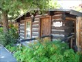 view gallery view galleryN26.9 km |  Yee Wau Cabin - Helena, MT Yee Wau Cabin - Helena, MT
in NRHP Historic Districts - Contributing Buildings From 1876 to 1886, the Yee Wau brothers, longtime local dealers in Chinese merchandise and groceries, owned the property. posted by: CerealBoxMonsters location: Montana date approved: 10/16/2009 last visited: 06/15/2013 |
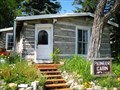 view gallery view galleryN26.9 km | Pioneer Cabin - Helena, MT in NRHP Historic Districts - Contributing Buildings Possibly the oldest standing structure in Helena, Wilson Butts followed the stampede to Last Chance Gulch in 1864, staked his claim here, and built this tiny, but serviceable, one-room cabin. posted by: CerealBoxMonsters location: Montana date approved: 10/17/2009 last visited: 06/15/2013 |
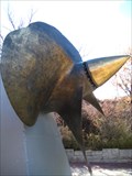 view gallery view galleryN26.9 km |  USS Helena - Helena, MT USS Helena - Helena, MT
in Ship Screws and Aircraft Props "Anchor Park" is a memorial to US Navy vessels that have bore the name Helena. There is a screw, an anchor and deck bell. posted by: CerealBoxMonsters location: Montana date approved: 11/18/2009 last visited: 06/15/2013 |
|