 view gallery view gallery SW10 km SW10 km
|   Garden Creek Equipment - Lewiston, ID Garden Creek Equipment - Lewiston, ID
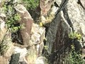
in Old Agricultural Equipment Various plows and other equipment at Garden Creek Preserve by Lewiston, ID. posted by:  saopaulo1 saopaulo1 location: Idaho date approved: 08/07/2017 last visited: never |
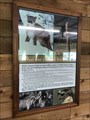 view gallery view gallerySW10 km |  What can you see here? - Lewiston, ID What can you see here? - Lewiston, ID
in Flora and Fauna Information Signs A sign at the Garden Creek Preserve by Lewiston, ID. posted by: saopaulo1 location: Idaho date approved: 08/15/2017 last visited: never |
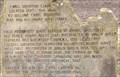
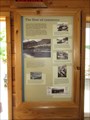 view gallery view gallerySW10 km |  The Flow of Commerce - Lewiston, ID The Flow of Commerce - Lewiston, ID
in Idaho Historical Markers A sign at the Garden Creek Preserve. posted by: saopaulo1 location: Idaho date approved: 09/12/2017 last visited: never |
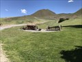
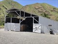 view gallery view gallerySW10 km |  Garden Creek Barn - Lewiston, ID Garden Creek Barn - Lewiston, ID
in Barns An old barn at the Garden Creek Preserve. posted by: saopaulo1 location: Idaho date approved: 08/08/2017 last visited: never |
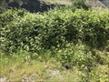 view gallery view gallerySW10.1 km |  Berry Picking at Garden Creek Preserve - Lewiston, ID Berry Picking at Garden Creek Preserve - Lewiston, ID
in Berry Picking Blackberry picking at this preserve by Lewiston. posted by: saopaulo1 location: Idaho date approved: 08/10/2017 last visited: never |
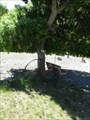 view gallery view gallerySW10.1 km |  Garden Creek Wheel - Lewiston, ID Garden Creek Wheel - Lewiston, ID
in Wagon Wheels This wheel is located in Garden Creek preserve by Lewiston, ID. posted by: saopaulo1 location: Idaho date approved: 08/08/2017 last visited: never |
 view gallery view gallerySW10.1 km |  WA/ID/OR on the Snake River WA/ID/OR on the Snake River
in Tripoints and Multipoints The tripoint for Oregon, Idaho and Washington. posted by: saopaulo1 location: Idaho date approved: 07/14/2017 last visited: 11/27/2020 |
 view gallery view gallerySW10.1 km |  Washington/Oregon on Snake River - near Joseph, OR Washington/Oregon on Snake River - near Joseph, OR
in Border Crossings The border of Washington and Oregon on the Snake River. posted by: saopaulo1 location: Oregon date approved: 07/13/2017 last visited: 11/27/2020 |
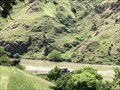
 view gallery view gallery S10.9 km S10.9 km
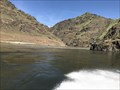
|  Hells Canyon National Recreational Area - Joseph, OR Hells Canyon National Recreational Area - Joseph, OR
in Geological Devilish Locations The entrance to the Hells Canyon National Recreational Area. posted by: saopaulo1 location: Oregon date approved: 08/05/2017 last visited: 11/27/2020 |
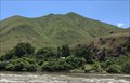 view gallery view galleryS10.9 km |  Hells Canyon National Recreational Area - Joseph, OR Hells Canyon National Recreational Area - Joseph, OR
in Public Access Lands The entrance to the Hells Canyon National Recreational Area. posted by: saopaulo1 location: Oregon date approved: 08/11/2017 last visited: 11/27/2020 |
 view gallery view gallery NW12.6 km NW12.6 km
|  Snake River Petroglyph - near Lewiston, ID Snake River Petroglyph - near Lewiston, ID
in Pictographs Petroglyphs on the rocks along the Snake River. posted by: saopaulo1 location: Idaho date approved: 08/06/2017 last visited: never |
 view gallery view gallery W22.9 km W22.9 km
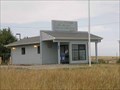
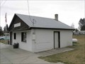
|  Anatone, WA. 99401 Anatone, WA. 99401
in U.S. Post Offices The post office building in Anatone, WA posted by: Volcanoguy location: Washington date approved: 10/23/2009 last visited: 09/28/2009 |
 view gallery view galleryW23.3 km |  Rattlesnake Summit on Hwy 129 - Washington Rattlesnake Summit on Hwy 129 - Washington
in Elevation Signs Elevation sign on Hwy. 129, south of Anatone. posted by: Volcanoguy location: Washington date approved: 09/14/2010 last visited: 12/02/2018 |
 view gallery view galleryS24.8 km |  CONFLUENCE - Snake River and Salmon River - Idaho CONFLUENCE - Snake River and Salmon River - Idaho
in River Origins, Destinations and Confluences The confluence of the Snake and Salmon River. posted by: saopaulo1 location: Idaho date approved: 07/14/2017 last visited: never |
 view gallery view gallery NE25.4 km NE25.4 km
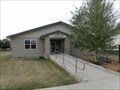
|  Winchester Community Library - Winchester, Idaho Winchester Community Library - Winchester, Idaho
in Libraries The Winchester Community Library serves the small community of Winchester, Idaho. posted by: Volcanoguy location: Idaho date approved: 01/19/2011 last visited: 09/29/2009 |
 view gallery view galleryNE25.4 km | Winchester, ID. 83555 in U.S. Post Offices The post office building in Winchester, ID posted by: Volcanoguy location: Idaho date approved: 10/24/2009 last visited: 09/29/2009 |
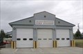 view gallery view galleryNE25.4 km |  Winchester Fire Station Winchester Fire Station
in Firehouses Firehouse for the community of Winchester, Idaho. posted by: Volcanoguy location: Idaho date approved: 01/19/2011 last visited: 09/29/2009 |
 view gallery view gallery N26.2 km N26.2 km
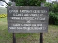
|  Tammany Creek Cemetery - Webb, ID Tammany Creek Cemetery - Webb, ID
in Abandoned Cemeteries Tammany Creek Cemetery is located off Tammany Creek Rd at the junction of Waha Rd. and Powell posted by: beagle39z location: Idaho date approved: 05/31/2012 last visited: never |
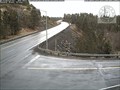 view gallery view galleryNE27.5 km |  Winchester South Web Camera - Winchester, MT Winchester South Web Camera - Winchester, MT
in Web Cameras This is one of about 150 highway traffic cameras in Idaho which cover every major and a great many of the minor thoroughfares in the state, as well as many of the towns and cities. posted by: T0SHEA location: Montana date approved: 04/04/2017 last visited: never |
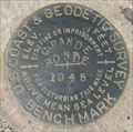 view gallery view galleryW31.2 km |  RZ1647 - USCGS GRANDE RONDE, Washington RZ1647 - USCGS GRANDE RONDE, Washington
in U.S. Benchmarks U.S. Coast & Geodetic Survey benchmark GRANDE RONDE, 1945. posted by: Volcanoguy location: Washington date approved: 09/16/2010 last visited: 09/28/2009 |
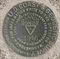 view gallery view galleryW31.2 km | RZ1048 - USCGS GRANDE RONDE, Washington in U.S. Benchmarks U.S. Coast & Geodetic Survey triangulation station GRANDE RONDE, 1946. posted by: Volcanoguy location: Washington date approved: 09/16/2010 last visited: 09/28/2009 |
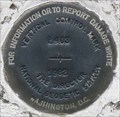 view gallery view galleryNE31.9 km | RZ1511 - NGS P403, Idaho in U.S. Benchmarks National Geodetic Survey Vertical Control Mark P403. posted by: Volcanoguy location: Idaho date approved: 01/18/2011 last visited: 09/29/2009 |
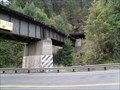 view gallery view galleryNE31.9 km |  Camas Prairie Railroad Bridge and Tunnel - Idaho Camas Prairie Railroad Bridge and Tunnel - Idaho
in Railroad Bridges Railroad bridge over Lapwai Creek and US Hwy 95. posted by: Volcanoguy location: Idaho date approved: 01/19/2011 last visited: 09/29/2009 |
 view gallery view galleryN31.9 km |  FIRST - William Craig - A man of Firsts. FIRST - William Craig - A man of Firsts.
in First of its Kind William Craig was the first permanent white settler in Idaho. posted by: Volcanoguy location: Idaho date approved: 01/16/2011 last visited: 09/29/2009 |
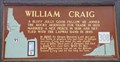 view gallery view galleryN31.9 km | #308 - William Craig in Idaho Historical Markers William Craig sign (#308) on U.S. Hwy. 95 betwee Lapwai and Culdesac. posted by: Volcanoguy location: Idaho date approved: 01/17/2011 last visited: 09/29/2009 |
|