 view gallery view gallery N2.3 km N2.3 km
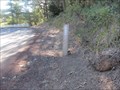
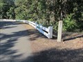
|   Mile Marker 81, Historic Hwy 30, Oregon Mile Marker 81, Historic Hwy 30, Oregon
in Milestones This is mile marker #81, on Historic Hwy 30, which was built between 1913 and 1922. posted by:  Queens Blessing Queens Blessing location: Oregon date approved: 08/17/2013 last visited: 09/02/2013 |
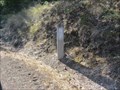 view gallery view galleryN2.3 km | Mile Marker 82, Historic Hwy 30 - The Dalles, OR in Milestones This is mile marker #82, on Historic Hwy 30, which was built between 1913 and 1922. posted by: Queens Blessing location: Oregon date approved: 08/11/2013 last visited: 09/02/2013 |
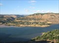
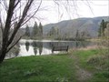
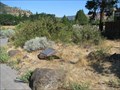
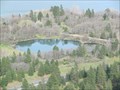 view gallery view galleryN3.1 km |  Kolk Pond, Rowena Crest, Oregon Kolk Pond, Rowena Crest, Oregon
in Glacial Lake Missoula Flood Features The classic kolk pond is just down the trail from Rowena Crest. posted by: Rose Red location: Oregon date approved: 04/08/2012 last visited: never |
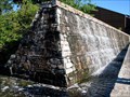
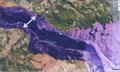 view gallery view galleryN3.1 km | Rowena Gap - a hydraulic dam in Glacial Lake Missoula Flood Features Rowena Gap is one of many hydraulic dams encountered by the Missoula Ice Age Floods. posted by: Rose Red location: Oregon date approved: 04/09/2012 last visited: never |
 view gallery view galleryN3.1 km | Missoula Ice Age Floods Gravel Bar, Lyle, Washington in Glacial Lake Missoula Flood Features Northeast of Rowena Crest is Lyle, Washington which was built on a huge gravel bar left by the cataclysmic Missoula Ice Age Floods. There is a great view of Lyle from Rowena Crest. posted by: Rose Red location: Washington date approved: 08/19/2008 last visited: 08/13/2011 |
 view gallery view gallery NW3.2 km NW3.2 km
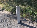
| Mile Marker 79, Historic Hwy 30, Oregon in Milestones This is mile marker #79, on Historic Hwy 30, which was built between 1913 and 1922. posted by: Queens Blessing location: Oregon date approved: 09/01/2013 last visited: 09/02/2013 |
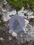 view gallery view galleryN3.7 km |  LYLE (RC2105) - KLICKITAT, WA LYLE (RC2105) - KLICKITAT, WA
in U.S. Benchmarks Off of Lyle Cherry Orchard trail. In a rock outcrop at ground level. posted by: lahontan location: Washington date approved: 12/15/2021 last visited: never |
 view gallery view galleryN4.2 km |  Lyle, WA. 98635 Lyle, WA. 98635
in U.S. Post Offices The post office building in Lyle, WA. posted by: Volcanoguy location: Washington date approved: 10/07/2009 last visited: 09/21/2009 |
 view gallery view galleryNW4.3 km | Mile Marker 78, Historic Hwy 30 - Mosier, Oregon in Milestones This is mile marker #78, on Historic Hwy 30, which was built between 1913 and 1922. posted by: Queens Blessing location: Oregon date approved: 08/10/2013 last visited: 09/02/2013 |
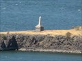
 view gallery view galleryN4.5 km |  BNSF Kilckitat River Railroad Bridge BNSF Kilckitat River Railroad Bridge
in Arch Bridges A 200' Open-Spandrel concrete arch rail bridge over the Klickitat River at its confluence with the Columbia River at Lyle, WA. posted by: HeyRob4449 location: Washington date approved: 08/09/2020 last visited: never |
 view gallery view gallery NE4.8 km NE4.8 km
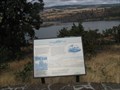
|  Near Lyle, Washington Near Lyle, Washington
in Lewis and Clark Trail This Lewis and Clark history sign is located along Wash. Hwy. 14 about 3 miles east of Lyle, Washington. posted by: Volcanoguy location: Washington date approved: 01/30/2010 last visited: 08/24/2013 |
 view gallery view galleryNE4.8 km |  Doug’s Beach State Park, Washington Doug’s Beach State Park, Washington
in 'You Are Here' Maps Map on Lewis and Clark sign along Wash. Hwy. 14. posted by: Volcanoguy location: Washington date approved: 01/29/2010 last visited: 09/21/2009 |
 view gallery view galleryNE4.8 km |  “friendly village” “friendly village”
in Washington Historical Markers This Lewis and Clark history sign is located at the Doug’s Beach State Park parking area along Wash. Hwy. 14 about 3 miles east of Lyle, Washington. posted by: Volcanoguy location: Washington date approved: 02/02/2010 last visited: 09/21/2009 |
 view gallery view galleryNW6 km |  Victor Trevitt's Grave, Memaloose Island, Oregon Victor Trevitt's Grave, Memaloose Island, Oregon
in Out of Place Graves Victor Trevitt was buried in 1883 on Memaloose Island according to his wish to be buried here among the people he loved. posted by: Rose Red location: Oregon date approved: 09/02/2009 last visited: 09/25/2015 |
 view gallery view galleryNW6 km | Sepulchar Island, near Hood River, Oregon in Lewis and Clark Trail The Corps of Discovery passed this point twice on their journey, and posted and explored the island on 13 April 1806. Today, the island is referred to as "Memaloose Island" but the explorers called it "sepulchar island". posted by: Queens Blessing location: Oregon date approved: 09/17/2012 last visited: 08/31/2013 |
 view gallery view gallery E6 km E6 km
| Kolk Pond at Columbia River Discovery Center, The Dalles, Oregon in Glacial Lake Missoula Flood Features A kolk pond at Columbia River Discovery Center. posted by: Rose Red location: Oregon date approved: 04/08/2012 last visited: 08/28/2018 |
 view gallery view galleryE6.1 km |  The Dalles, Oregon- Native Plant Restoration Project The Dalles, Oregon- Native Plant Restoration Project
in Demonstration Gardens The Native Plant Restoration Project is located on the grounds of the Columbia River Gorge Discovery Center and Wasco County Museum, in The Dalles, Oregon. posted by: Queens Blessing location: Oregon date approved: 07/14/2008 last visited: 08/28/2018 |
 view gallery view galleryE6.1 km |  The Dalles, OR - Waterfall at the Gorge Discovery Center The Dalles, OR - Waterfall at the Gorge Discovery Center
in Man-made Waterfalls This is the waterfall that visitors walk past to gain entrance to the Gorge Discovery Center and Wasco County Museum in The Dalles, Oregon. posted by: Queens Blessing location: Oregon date approved: 07/15/2008 last visited: 08/28/2018 |
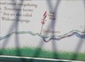
 view gallery view galleryNW6.1 km |  The Literary Oregon Trail The Literary Oregon Trail
in Oregon Historical Markers This is one of 13 historical markers in a special kiosk, devoted to the history of the Oregon Trail, and located at the Memaloose Park Rest Area on the south side of Interstate Highway 84 about 3.1 miles east of Mosier, Oregon. posted by: brwhiz location: Oregon date approved: 02/05/2013 last visited: 06/25/2014 |
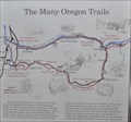 view gallery view galleryNW6.1 km | The Many Oregon Trails in Oregon Historical Markers This is one of 13 historical markers in a special kiosk, devoted to the history of the Oregon Trail, and located at the Memaloose Park Rest Area on the south side of Interstate Highway 84 about 3.1 miles east of Mosier, Oregon. posted by: brwhiz location: Oregon date approved: 02/05/2013 last visited: 06/25/2014 |
 view gallery view galleryNW6.1 km | Diseases Devastate Tribes in Oregon Historical Markers This is one of 13 historical markers in a special kiosk, devoted to the history of the Oregon Trail, and located at the Memaloose Park Rest Area on the south side of Interstate Highway 84 about 3.1 miles east of Mosier, Oregon. posted by: brwhiz location: Oregon date approved: 02/05/2013 last visited: 06/25/2014 |
 view gallery view galleryNW6.1 km | Indians and Emigrants in Oregon Historical Markers This is one of 13 historical markers in a special kiosk, devoted to the history of the Oregon Trail, and located at the Memaloose Park Rest Area on the south side of Interstate Highway 84 about 3.1 miles east of Mosier, Oregon. posted by: brwhiz location: Oregon date approved: 02/05/2013 last visited: 06/25/2014 |
 view gallery view galleryNW6.1 km | Land Not for Sale in Oregon Historical Markers This is one of 13 historical markers in a special kiosk, devoted to the history of the Oregon Trail, and located at the Memaloose Park Rest Area on the south side of Interstate Highway 84 about 3.1 miles east of Mosier, Oregon. posted by: brwhiz location: Oregon date approved: 02/05/2013 last visited: 06/25/2014 |
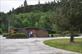 view gallery view galleryNW6.1 km |  Memaloose Park Rest Area ~ Eastbound Memaloose Park Rest Area ~ Eastbound
in Highway Rest Areas The Memaloose Park Rest Area is located on the south side of Interstate Highway 84, within the boundaries of Memaloose State Park, about 3.1 miles east of Mosier, Oregon. posted by: brwhiz location: Oregon date approved: 02/04/2013 last visited: 06/25/2014 |
 view gallery view galleryNW6.1 km | Pathway to the "Garden of the World" in Oregon Historical Markers This is one of 13 historical markers in a special kiosk, devoted to the history of the Oregon Trail, and located at the Memaloose Park Rest Area on the south side of Interstate Highway 84 about 3.1 miles east of Mosier, Oregon. posted by: brwhiz location: Oregon date approved: 02/03/2013 last visited: 06/25/2014 |
|