 view gallery view gallery NW0 km NW0 km
|   Battle of the Cascades, Indian War of 1855-1856, Washington Battle of the Cascades, Indian War of 1855-1856, Washington
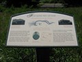
in Battlefields The Battle of the Cascades during Indian War of 1855-1856 resulted in additional forts built in the Columbia River Gorge. posted by:  Rose Red Rose Red location: Washington date approved: 05/26/2007 last visited: never |
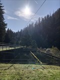
 view gallery view galleryNW0 km |  Forts Cascade, Rains and Lugenbeel Forts Cascade, Rains and Lugenbeel
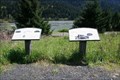
in Washington Historical Markers Two signs side by side, one marking the use of the railroad in the area, the other describing the three forts that were built to protect the settlers. posted by: Og's outfit location: Washington date approved: 04/25/2006 last visited: 09/16/2017 |
 view gallery view gallery W0.6 km W0.6 km
|  PCT Omnivore PCT Omnivore
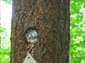
in Omnivorous Trees A marker for the fabulous Pacific Crest Trail is being swallowed by the tree bearing it. posted by: dkestrel location: Washington date approved: 07/21/2013 last visited: 10/29/2013 |
 view gallery view gallery S0.6 km S0.6 km
|  Sheridan State Park - Oregon Sheridan State Park - Oregon
in State/Provincial Parks Sheridan State Scenic Corridor is a state park in the Columbia River Gorge, west of Cascade Locks, Oregon. posted by: howarthe location: Oregon date approved: 03/25/2010 last visited: 03/23/2010 |
 view gallery view gallery SW1.4 km SW1.4 km
|  Cascade Fish Hatchery - Cascade Locks, OR Cascade Fish Hatchery - Cascade Locks, OR
in Satellite Imagery Oddities The Cascade Fish Hatchery in Cascade Locks, OR. posted by: saopaulo1 location: Oregon date approved: 07/19/2022 last visited: never |
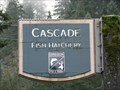 view gallery view gallerySW1.4 km |  Cascade Fish Hatchery - Cascade Locks, Oregon Cascade Fish Hatchery - Cascade Locks, Oregon
in Fish Hatcheries Coho salmon fish hatchery managed by the Oregon Depart of Fish and Wildlife. posted by:  BruceS BruceS location: Oregon date approved: 04/11/2009 last visited: 12/30/2013 |
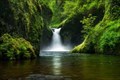 view gallery view gallerySW1.6 km |  Eagle Creek - Bonnville, OR Eagle Creek - Bonnville, OR
in National Wild and Scenic Rivers Discover a canyon full of waterfalls in the Columbia Gorge. posted by: dkestrel location: Oregon date approved: 01/09/2014 last visited: 01/11/2014 |
 view gallery view gallery NE1.6 km NE1.6 km
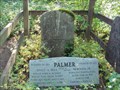
|  Emily Palmer Bell and her younger brother, Norman Palmer Jr. Emily Palmer Bell and her younger brother, Norman Palmer Jr.
in Out of Place Graves This hidden and relatively unknown gravesite of Emily Palmer Bell and her younger brother Norman Palmer Jr. is located on the Washington side just east of the Bridge of the Gods, a few steps down a trail leading into the woods. posted by: Rose Red location: Washington date approved: 07/11/2011 last visited: 07/11/2014 |
 view gallery view galleryNE1.8 km |  Bridge of the Gods, Washington Bridge of the Gods, Washington
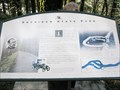
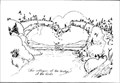
in Lewis and Clark Trail “The rocks project into the river in maney places and have the appearance of having fallen from the highe hills...We can plainly hear the roreing of the grand shutes below…".
posted by: Rose Red location: Washington date approved: 05/28/2007 last visited: 10/06/2022 |
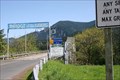 view gallery view galleryNE1.8 km | Bridge of the Gods in Washington Historical Markers A marker near the modern Bridge of the Gods. This is a toll bridge. posted by: Og's outfit location: Washington date approved: 04/25/2006 last visited: 10/06/2022 |
 view gallery view galleryNE1.8 km |  Bridge of the Gods, Cascade Locks, Oregon - "Amazing Race 13" Bridge of the Gods, Cascade Locks, Oregon - "Amazing Race 13"
in Movie Locations In “Amazing Race 13” multiple teams raced around the globe for $1,000,000 to 'amazing' locations. At Cascade Locks they descended on a zip line 2,000 feet from the Bridge of the Gods to an island in the final leg of the race. posted by: Rose Red location: Oregon date approved: 12/11/2008 last visited: 06/07/2021 |
 view gallery view galleryNE1.8 km |  Bridge of the Gods, Cascade Locks, Oregon Bridge of the Gods, Cascade Locks, Oregon
in Glacial Lake Missoula Flood Features Ever since the eroding Missoula Flood steepened the valley wall, volcanic rock has been sliding in a series of giant landslides. Between 750 and 1,300 years ago half of Table Mountain broke way in a colossal slide that completely blocked the river. posted by: Rose Red location: Oregon date approved: 02/06/2007 last visited: 10/06/2022 |
 view gallery view galleryNE1.8 km | Bridge of the Gods - "Twilight" in Movie Locations Charlie(Billie Burke)gives Bella(Kristen Stewart)a ride home from the airport crossing this bridge in one of the opening scenes from Twilight. This is also the bridge from the book "Wild" by Cheryl Strayed and the bridge was her final destination posted by:  Doug Mathieson Doug Mathieson location: Oregon date approved: 08/19/2010 last visited: 06/07/2021 |
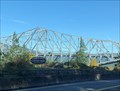 view gallery view galleryNE1.9 km | Bridge of the Gods - Cascade Locks, OR in Satellite Imagery Oddities The Bridge of the Gods in Cascade Locks, OR. posted by: saopaulo1 location: Oregon date approved: 07/05/2022 last visited: never |
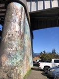 view gallery view galleryNE1.9 km | Bridge of the Gods Mural - Cascade Locks, OR in Satellite Imagery Oddities A large mural on the side of the Bridge of the Gods in Cascade Locks, OR posted by: saopaulo1 location: Oregon date approved: 07/05/2022 last visited: never |
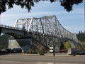
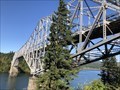
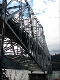 view gallery view galleryNE1.9 km |  Bridge of the Gods - Cascade Locks, Oregon Bridge of the Gods - Cascade Locks, Oregon
in Wikipedia Entries Steel truss cantilever bridge spanning the Columbia River from Cascade Locks, Oregon to Washington state. posted by: BruceS location: Oregon date approved: 03/20/2009 last visited: 06/09/2019 |
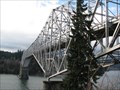 view gallery view galleryNE1.9 km |  Bridge of the Gods - Cascade Locks, Oregon Bridge of the Gods - Cascade Locks, Oregon
in Truss Bridges Steel truss cantilever bridge spanning the Columbia River from Cascade Locks, Oregon to Washington state.
posted by: BruceS location: Oregon date approved: 03/20/2009 last visited: 06/07/2021 |
 view gallery view galleryNE1.9 km |  Bridge of the Gods - Cascade Locks, Oregon Bridge of the Gods - Cascade Locks, Oregon
in American Guide Series Steel truss cantilever bridge spanning the Columbia River from Cascade Locks, Oregon to Washington state. posted by: BruceS location: Oregon date approved: 03/25/2009 last visited: 06/07/2021 |
 view gallery view galleryNE1.9 km |  Deputies stop Bridge of Gods jump Deputies stop Bridge of Gods jump
in News Article Locations Deputies stop a suicide attempt. posted by: saopaulo1 location: Oregon date approved: 07/07/2022 last visited: never |
 view gallery view galleryNE1.9 km |  Welcome to Cascade Locks, Oregon, Heart of the Gorge Welcome to Cascade Locks, Oregon, Heart of the Gorge
in Welcome Signs This is the Welcome sign in Cascade Locks, Oregon, "Heart of the Gorge". posted by: Queens Blessing location: Oregon date approved: 06/17/2008 last visited: 08/28/2018 |
 view gallery view galleryNE2.1 km |  Bridge of the Gods Trailhead, Gorge Trail #400, Cascade Locks, Oregon Bridge of the Gods Trailhead, Gorge Trail #400, Cascade Locks, Oregon
in Long Distance Hiking Trails At the Bridge of the Gods Trailhead you are located at the heart of the Columbia River Gorge National Scenic area, stretching from the Deschutes River west to Troutdale, Oregon. posted by: Rose Red location: Oregon date approved: 05/27/2007 last visited: 12/29/2013 |
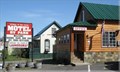 view gallery view galleryNE2.1 km |  Bridge of the Gods Motel, RV Park & Cabins - Cascade Locks, Oregon Bridge of the Gods Motel, RV Park & Cabins - Cascade Locks, Oregon
in Chalet, Cottage, and Cabin Style Lodging a complex of motel rooms, cabins & a RV Park located on Wa Na Pa Street in Cascade Locks, Oregon, USA posted by: oiseau_ca location: Oregon date approved: 11/25/2015 last visited: 06/07/2021 |
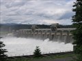 view gallery view gallerySW2.3 km |  Bonneville Dam, Oregon Bonneville Dam, Oregon
in Water Dams Bonneville Dam, located 145 miles from the mouth of the Columbia River, was built from 1933 to late 1930s by the U.S. Army Corps of Engineers. It is the oldest of four massive Army Corps of Engineers projects along the Columbia River. posted by: Rose Red location: Oregon date approved: 11/27/2006 last visited: 06/07/2021 |
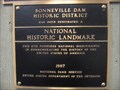 view gallery view gallerySW2.3 km |  Bonneville Dam Historic District; Also known as Powerhouse, Navigation Lock and Administrative Site, and the Bonneville Dam Historic District (Boundary Increase--added 1987); Also known as Bonneville Hatchery; Central Hatchery, Oregon Bonneville Dam Historic District; Also known as Powerhouse, Navigation Lock and Administrative Site, and the Bonneville Dam Historic District (Boundary Increase--added 1987); Also known as Bonneville Hatchery; Central Hatchery, Oregon
in U.S. National Register of Historic Places Bonneville Dam, located 145 miles from the mouth of the Columbia River, was built from 1933 to late 1930s by the U.S. Army Corps of Engineers. It is the oldest of four massive Army Corps of Engineers projects along the Columbia River. posted by: Rose Red location: Oregon date approved: 06/24/2006 last visited: 06/09/2019 |
 view gallery view gallerySW2.3 km |  "Roll On Columbia," Bonneville Dam, Oregon "Roll On Columbia," Bonneville Dam, Oregon
in Immortalized in Lyrics It was undoubtedly one of the strangest alliances ever forged in the Pacific Northwest--Woody Guthrie and the Bonneville Power Administration. posted by: Rose Red location: Oregon date approved: 04/25/2006 last visited: 06/07/2021 |
|