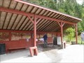
 view gallery view gallery SE2.6 km SE2.6 km
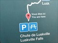
|   Luskville Falls ////////// Luskville Falls //////////
in Waterfalls This Gatineau Park waterfall trail is best visited in early Spring and perhaps again in the fall of the year to capture the Autumn colours! posted by:  JohnMc JohnMc location: Québec, Canada date approved: 03/26/2006 last visited: 12/20/2020 |
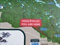
 view gallery view gallerySE2.6 km |  You Are Here - Lusk Falls Trail , Gatineau, Quebec You Are Here - Lusk Falls Trail , Gatineau, Quebec
in 'You Are Here' Maps At parking for the Lusk Falls trail. posted by: The Burrow location: Québec, Canada date approved: 09/16/2020 last visited: never |
 view gallery view gallerySE2.6 km | You Are Here - Eardley Escarpment , Gatineau, Quebec in 'You Are Here' Maps At parking for the Eardley Escarpment. posted by: The Burrow location: Québec, Canada date approved: 09/16/2020 last visited: never |
 view gallery view gallery NE4.5 km NE4.5 km
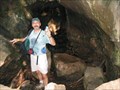
| ") Lusk Cave, Gatineau Park, Gatineau, Quebec Lusk Cave, Gatineau Park, Gatineau, Quebec
in Cave Entrances (Natural) A 12,500 year old cave, unusual in that it transects a hill! posted by: bluelamb03 location: Québec, Canada date approved: 05/12/2011 last visited: 11/17/2019 |
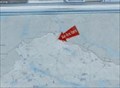
 view gallery view gallery SW7.4 km SW7.4 km
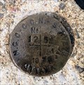
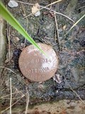
|  NCC BM 1252 - Constance Bay, ON NCC BM 1252 - Constance Bay, ON
in Canadian Benchmarks For public access, use the signed entrances to the beach. Then follow the beach to the navigation light. posted by: elyob location: Ontario, Canada date approved: 07/02/2022 last visited: never |
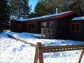
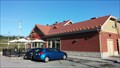
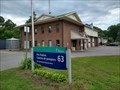 view gallery view gallerySW7.4 km |  Fire Station #63 Fire Station #63
in Firehouses Located in Constance Bay, the station is northwest of the intersection of Bayview Drive and Bishop Davis Drive. posted by: elyob location: Ontario, Canada date approved: 07/31/2022 last visited: never |
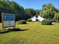 view gallery view gallerySW8 km |  St. Gabriel's Roman Catholic Church - Constance Bay, Ontario St. Gabriel's Roman Catholic Church - Constance Bay, Ontario
in Roman Catholic Churches The church is on the west side of Bayview Drive, north of Hunter Crescent. posted by: elyob location: Ontario, Canada date approved: 08/14/2022 last visited: never |
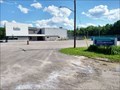 view gallery view gallerySW8.2 km |  NorthWind Wireless Community Centre, Constance Bay, Ontario NorthWind Wireless Community Centre, Constance Bay, Ontario
in Municipal Community Centers The large sign is at the posted co-ordinates. posted by: elyob location: Ontario, Canada date approved: 08/07/2022 last visited: never |
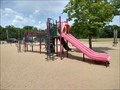 view gallery view gallerySW8.2 km |  Community Centre Playground, Constance Bay, Ontario Community Centre Playground, Constance Bay, Ontario
in Public Playgrounds 262 Len Purcell Drive posted by: elyob location: Ontario, Canada date approved: 07/24/2022 last visited: 07/29/2022 |
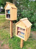 view gallery view gallerySW8.5 km |  Constance Bay Little Free Library (#139428) - Constance Bay, Ontario Constance Bay Little Free Library (#139428) - Constance Bay, Ontario
in Free Community Book Exchanges Head south on Baillie Avenue which is near the bend of Constance Bay Road and Bayview Drive. posted by: elyob location: Ontario, Canada date approved: 08/21/2022 last visited: never |
 view gallery view galleryNE9.5 km |  Brown Cabin - Gatineau Park, Quebec Brown Cabin - Gatineau Park, Quebec
in Remote Backcountry Shelters Brown Lake Cabin in beautiful Gatineau Park is a wonderful way to spend the night. It sleeps up to 17 people. posted by: Trail Blaisers location: Québec, Canada date approved: 03/13/2014 last visited: never |
 view gallery view gallery E10.1 km E10.1 km
| ") Pont du Ruisseau-Meech - Chelsea, Québec Pont du Ruisseau-Meech - Chelsea, Québec
in Histoire du Quebec (Quebec Historical Markers) Le pont couvert du ruisseau Meech, construit en 1924, est un pont à treillis de type «Town» qui enjambe le ruisseau Meech, à Chelsea, dans la région de l’Outaouais. posted by: Weathervane location: Québec, Canada date approved: 02/23/2013 last visited: 11/17/2019 |
 view gallery view gallerySW10.1 km | 68U014 - Woodlawn, ON in Canadian Benchmarks This can be a dangerous intersection. posted by: elyob location: Ontario, Canada date approved: 07/21/2022 last visited: never |
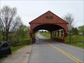 view gallery view gallery N10.3 km N10.3 km
|  1958 Covered Bridge - Gatineau Park, QC 1958 Covered Bridge - Gatineau Park, QC
in Covered Bridges A red painted wooden covered bridge crossing the La Peche River just outside the east entrance to Gatineau Park. posted by: model12 location: Québec, Canada date approved: 05/19/2011 last visited: 11/17/2019 |
 view gallery view galleryNE10.6 km |  Tim Hortons - 151 Chemin Valley, Gatineau, QC Tim Hortons - 151 Chemin Valley, Gatineau, QC
in Tim Horton's Restaurants This Tim Hortons is located near the junction of Hwy 366 and Hwy 105. posted by: The Burrow location: Québec, Canada date approved: 07/29/2017 last visited: 11/17/2019 |
 view gallery view galleryNE10.6 km |  Tim Horton's - Wi-Fi Hotspot - 151 Chemin Valley, Wakefield, QC Tim Horton's - Wi-Fi Hotspot - 151 Chemin Valley, Wakefield, QC
in Wi-Fi Hotspots The restaurant offers free Wifi connections, as do most Tim Hortons outlets in Canada. posted by: The Burrow location: Ontario, Canada date approved: 07/29/2017 last visited: never |
 view gallery view galleryNE10.6 km | YAH - P17 Parking Lot, Wakefield, Quebec in 'You Are Here' Maps A covered YAH map with wings holding bulletins about the local wildlife and plants. posted by: model12 location: Québec, Canada date approved: 05/19/2011 last visited: 06/11/2015 |
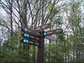 view gallery view galleryNE10.8 km |  The Trail 52 @ Trail 53, Gatineau Park, Quebec The Trail 52 @ Trail 53, Gatineau Park, Quebec
in Direction and Distance Arrows The trail indicator at the intersection of the Trail 52, Trans Canada Trail, and Trail 53, the Kennedy Road, in the National Capital Commission's Gatineau Park. posted by: bluelamb03 location: Québec, Canada date approved: 05/15/2011 last visited: 07/21/2013 |
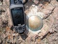 view gallery view galleryE10.8 km | Meech Lake / Baie Alexander - Boathouse View Benchmark in Canadian Benchmarks National Capital Commission (NCC) Benchmark #203 - Meech Lake posted by: Kirok location: Québec, Canada date approved: 04/25/2011 last visited: 06/16/2020 |
 view gallery view galleryNE10.9 km |  Great Canadian Bungee - Wakefield, Quebec Great Canadian Bungee - Wakefield, Quebec
in Bungee Jump Sites Great Canadian Bungee is located just south of Wakefield, Quebec. posted by: InGodsHands location: Québec, Canada date approved: 09/29/2010 last visited: 02/06/2022 |
 view gallery view galleryNE10.9 km | Lorne Shouldice Spring - Wakefield, Quebec in Spring Houses Dedicated to Lorne Shouldice, who saved the spring from destruction during road construction in 1986. posted by: model12 location: Québec, Canada date approved: 05/19/2011 last visited: 08/11/2017 |
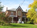 view gallery view galleryNE11.3 km | Maison MacLaren - La Pêche, Québec in Histoire du Quebec (Quebec Historical Markers) La maison Maclaren est située sur le chemin Mill, dans le village de La Pêche, au Québec. posted by: Weathervane location: Québec, Canada date approved: 10/06/2012 last visited: 06/21/2023 |
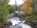 view gallery view galleryNE11.3 km |  Wakefield Grist Mill - Wakefield, QC Wakefield Grist Mill - Wakefield, QC
in Water Mills William Fairbarin built this grist mill for the area in 1838. posted by: JSDAFM location: Québec, Canada date approved: 10/21/2010 last visited: 06/21/2023 |
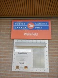 view gallery view galleryNE11.4 km |  BP WAKEFIELD PO - QC - J0X 3G0 BP WAKEFIELD PO - QC - J0X 3G0
in Canada Post Offices This is a stand alone post office on one of the main streets serving the village of Wakefield and surrounding area. posted by: waxwing454 location: Québec, Canada date approved: 08/07/2015 last visited: 06/21/2023 |
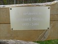 view gallery view galleryNE11.4 km |  Bernard Sicotte - Wakefield, Quebec Bernard Sicotte - Wakefield, Quebec
in Dedicated Benches A log bench at the trailhead of the Wakefield Trail. posted by: model12 location: Québec, Canada date approved: 05/19/2011 last visited: 06/11/2015 |
|