 view gallery view gallery E10.6 km E10.6 km
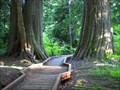
|   Lost Lake Boardwalk, Oregon Lost Lake Boardwalk, Oregon
in Non-Coastal Boardwalks Around the beautiful Lost Lake in the Mt Hood National Forest is a boardwalk with picturesque views. posted by:  DocDTA DocDTA location: Oregon date approved: 12/28/2013 last visited: 12/30/2013 |
 view gallery view gallery NE12.6 km NE12.6 km
|  Seven and a Half Mile Camp, Eagle Creek Trail, Columbia Gorge, Oregon Seven and a Half Mile Camp, Eagle Creek Trail, Columbia Gorge, Oregon
in Free Campsites Seven and a Half Mile Camp is the last campsite the Eagle Creek Trail before it starts gaining elevation on the long stretch up to Wahtum Lake. posted by: DocDTA location: Oregon date approved: 01/12/2014 last visited: 01/12/2014 |
 view gallery view gallery NW13.7 km NW13.7 km
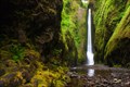
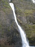
|  Oneonta Falls Oneonta Falls
in Waterfalls The 65 foot Oneonta Falls is hidden from view and the main path bypasses it completely. The falls is rare treat for those who seek it. posted by: PYNEKONE location: Oregon date approved: 08/29/2011 last visited: 08/18/2011 |
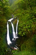 view gallery view galleryNW14 km | Triple Falls in Waterfalls Triple Falls is considered one of the prettiest waterfalls in the Columbia River Gorge along Oneonta Creek. posted by: PYNEKONE location: Oregon date approved: 08/31/2011 last visited: 08/31/2011 |
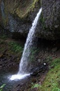
 view gallery view galleryNW14.6 km | Upper Oneonta Falls - Columbia River Highway, Oregon in Waterfalls Upper Oneonta Falls and the Oneonta Gorge are accessed from the trail adjacent to the roadside Horsetail Falls. The Forest Service has designated the area as a botanical area because of the unique aquatic and woodland plants that grow there. posted by:  Hikenutty Hikenutty location: Oregon date approved: 01/05/2008 last visited: 10/18/2008 |
 view gallery view galleryNW14.6 km | Lower Oneonta Falls in Waterfalls 100 foot Plunge style waterfall in the Columbia River Gorge posted by: PYNEKONE location: Oregon date approved: 08/28/2011 last visited: 08/29/2011 |
 view gallery view galleryNW14.8 km |  Massive Landslide, Dodson, Oregon Massive Landslide, Dodson, Oregon
in Glacial Lake Missoula Flood Features More than 15,000 years ago the largest and most powerful scientifically documented freshwater flood to occur on earth happened in the Pacific Northwest. Afterwards the drastically eroded Columbia River valley walls ended in steep vertical slopes. posted by: Rose Red location: Oregon date approved: 02/03/2007 last visited: never |
 view gallery view gallery N14.8 km N14.8 km
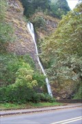
| Ponytail Falls (Upper Horsetail Falls) - Columbia River Hwy., OR in Waterfalls Ponytail Falls is one of the many beautiful waterfalls that can be found along the Oregon side of the Columbia River. The falls are a short walk up the trail from the roadside Horsetail Falls. posted by: Hikenutty location: Oregon date approved: 01/02/2008 last visited: 09/13/2013 |
 view gallery view galleryNW15 km |  Horsetail Falls - Oregon Horsetail Falls - Oregon
in Wikipedia Entries N 45° 35.408 W 122° 04.127
10T E 572636 N 5048931
Quick Description: Waterfalls easily accessible from the Columbia River Highway. posted by:  BruceS BruceS location: Oregon date approved: 02/15/2010 last visited: 07/10/2017 |
 view gallery view galleryNW15 km |  Horsetail Falls - Columbia River Highway Horsetail Falls - Columbia River Highway
in American Guide Series Waterfalls easily accessible from the Columbia River Highway.
posted by: BruceS location: Oregon date approved: 03/02/2009 last visited: 11/27/2020 |
 view gallery view galleryNW15 km |  Mom dies, 3-year-old hurt in fall at Horsetail Falls Mom dies, 3-year-old hurt in fall at Horsetail Falls
in News Article Locations A fall at a waterfall in Oregon. posted by: saopaulo1 location: Oregon date approved: 07/12/2022 last visited: never |
 view gallery view galleryNW15 km |  Oneonta Gorge Oneonta Gorge
in Places of Geologic Significance The Oneonta Gorge is a slot canyon 20 feet wide, 250 feet deep and is one-fourth mile long. A crack in the ground is as straight as an arrow. The Gorge is a Nature Preserve protecting the rare plants and the unique shear basalt walls. posted by: PYNEKONE location: Oregon date approved: 08/29/2011 last visited: 04/26/2012 |
 view gallery view galleryNW15 km | Horsetail Falls - Columbia Gorge, Oregon in Waterfalls Horsetail Falls is found in the Columbia River Gorge along Oregon's Columbia River Highway. The waterfall can be seen from the highway. posted by: Hikenutty location: Oregon date approved: 01/02/2008 last visited: 05/26/2023 |
 view gallery view galleryNW15 km |  Horsetail Falls - Historic Columbia River Highway - OR Horsetail Falls - Historic Columbia River Highway - OR
in National Scenic Byways Horsetail Falls is one of several waterfalls that can be seen along the Historic Columbia River Highway. Adjacent to this falls is a trail that leads up to three other falls: Ponytail Falls, Upper Oneanta Falls, and Triple Falls. posted by: Hikenutty location: Oregon date approved: 05/26/2008 last visited: 11/27/2020 |
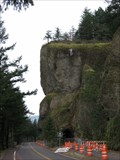
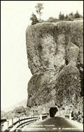 view gallery view galleryNW15.1 km |  Oneonta Tunnel, Historic Columbia River Highway, Oregon Oneonta Tunnel, Historic Columbia River Highway, Oregon
in Photos Then and Now The 125’ straight bore Oneonta Tunnel (1914), one of four tunnels on the Historic Columbia River Highway, was reopened August 19, 2006. For the first time since it was filled with debris in 1948, daylight could be seen through the tunnel. posted by: Rose Red location: Oregon date approved: 03/10/2007 last visited: 07/10/2017 |
 view gallery view galleryNW15.1 km | Missoula Flood & Oneonta, Oregon in Glacial Lake Missoula Flood Features Before the Missoula Flood, the Columbia River valley walls sloped gently down to the river. Afterwards, the drastically eroded valley walls ended in steep vertical slopes, such as the eroded 200’ Oneonta basalt wall. posted by: Rose Red location: Oregon date approved: 02/10/2007 last visited: 07/10/2017 |
 view gallery view galleryNW15.1 km |  Oneonta Tunnel - Columbia River Highway Oneonta Tunnel - Columbia River Highway
in NRHP Historic Districts - Contributing Buildings Historic highway tunnel, now bypassed, has been restored as a pedestrian tunnel after being filled rubble for more than a half a century.
posted by: BruceS location: Oregon date approved: 03/02/2009 last visited: 07/10/2017 |
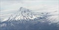 view gallery view gallery SE15.3 km SE15.3 km
| Mount Hood - Oregon in Wikipedia Entries Mount Hood is a mountain in Oregon. posted by: saopaulo1 location: Oregon date approved: 06/30/2017 last visited: 11/10/2019 |
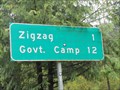 view gallery view gallery S15.4 km S15.4 km
|  Zigzag, Oregon Zigzag, Oregon
in 'Z' Welcome Signs Zigzag is a small mountain community in the Mt. Hood corridor of Oregon. posted by: DougK location: Oregon date approved: 05/07/2010 last visited: 01/11/2014 |
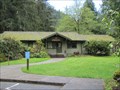 view gallery view galleryS15.6 km |  Zigzag Ranger Station - Zigzag, OR Zigzag Ranger Station - Zigzag, OR
in U.S. National Register of Historic Places The Zigzag Ranger Station consists of nineteen historic buildings on 125 acres in Mt. Hood National Forest or Oregon. posted by: DougK location: Oregon date approved: 05/07/2010 last visited: 11/10/2019 |
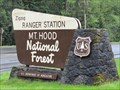 view gallery view galleryS15.6 km |  Zigzag Ranger Station - Mt. Hood National Forest - Zigzag, OR Zigzag Ranger Station - Mt. Hood National Forest - Zigzag, OR
in Ranger Stations The Zigzag Ranger Station serves the Mt. Hood National Forest area. posted by: DougK location: Oregon date approved: 05/11/2010 last visited: 11/10/2019 |
 view gallery view galleryNE15.9 km |  Chinidere Mountain, Oregon Chinidere Mountain, Oregon
in Mountain Summits A nice summit sitting next to Wahtum Lake. posted by: DocDTA location: Oregon date approved: 12/22/2013 last visited: 12/22/2013 |
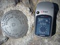 view gallery view galleryNE15.9 km |  Chinidere Mountain Earthquake Research Marker Chinidere Mountain Earthquake Research Marker
in U.S. Benchmarks Dept. of Interior Nat'l Ctr for Earthquake Research 1981 posted by: tbarhunt location: Oregon date approved: 09/02/2010 last visited: never |
 view gallery view galleryN16.3 km | 0079A - Skamania Co, WA in U.S. Benchmarks Brass cap set in concrete at top of boat ramp. posted by: lahontan location: Washington date approved: 12/15/2021 last visited: never |
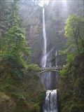 view gallery view galleryNW16.3 km | Multnomah Falls in Waterfalls This amazing waterfall is the third tallest in the United States. posted by: cachegame location: Oregon date approved: 10/21/2006 last visited: 12/30/2022 |
|