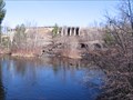
 view gallery view gallery E12.7 km E12.7 km
|   High Falls Flowage - Marinette County, WI High Falls Flowage - Marinette County, WI
in Water Dams High Falls Flowage located in Central Marinette County, WI. posted by:  Team B Squared Team B Squared location: Wisconsin date approved: 01/28/2009 last visited: never |
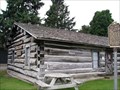 view gallery view gallery NW13.2 km NW13.2 km
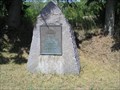
|  Holt and Balcom Logging Camp No. 1 - Lakewood, WI Holt and Balcom Logging Camp No. 1 - Lakewood, WI
in U.S. National Register of Historic Places Holt and Balcom Logging Camp No. 1 on grounds of McCauslin Brook Golf Course in Lakewood. posted by: frankhj location: Wisconsin date approved: 08/11/2007 last visited: never |
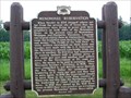
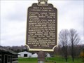 view gallery view galleryNW13.2 km |  Holt & Balcom Logging Camp No. 1 Holt & Balcom Logging Camp No. 1
in Wisconsin Historical Markers Holt & Balcom Logging Camp No. 1 Marker on the grounds of McCauslin Brook Golf Course in Lakewood. posted by: frankhj location: Wisconsin date approved: 08/13/2007 last visited: never |
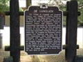 view gallery view gallery W30.4 km W30.4 km
| De Langlade in Wisconsin Historical Markers De Langlade Marker in Langlade. posted by: frankhj location: Wisconsin date approved: 08/13/2007 last visited: 01/30/2022 |
 view gallery view gallery SE31.4 km SE31.4 km
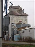
|  King Midas/Doboy, Coleman, Wisconsin King Midas/Doboy, Coleman, Wisconsin
in Ghost Signs King Midas/Doboy ghost sign on the north side of the old Coleman Feedmill. posted by:  swamp soggin swamp soggin location: Wisconsin date approved: 04/15/2013 last visited: 11/18/2014 |
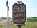 view gallery view gallerySE32.7 km | Lena Road Schoolhouse in Wisconsin Historical Markers Lena Road Schoolhouse Marker S. of Pound. posted by: frankhj location: Wisconsin date approved: 08/13/2007 last visited: 12/17/2010 |
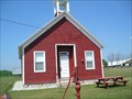 view gallery view gallerySE32.7 km | Lena Road School - Pound, WI in U.S. National Register of Historic Places Lena Road School in Marinette County, WI. (Note: It is spelled incorrectly in the Register as Kena). posted by: frankhj location: Wisconsin date approved: 08/11/2007 last visited: 05/15/2011 |
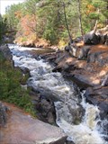
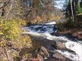
 view gallery view gallery NE38.1 km NE38.1 km
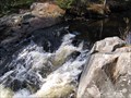
|  Horseshoe Falls - Marinette County, WI Horseshoe Falls - Marinette County, WI
in Waterfalls Horseshoe Falls in Marinette County, Wisconsin. posted by: Team B Squared location: Wisconsin date approved: 01/27/2009 last visited: never |
 view gallery view galleryNE40.1 km | Dave's Falls - Amberg, WI in Waterfalls Dave's Falls located in Amberg, Wisconsin. posted by: Team B Squared location: Wisconsin date approved: 01/27/2009 last visited: 03/01/2011 |
 view gallery view galleryNE42.3 km | Eighteenfoot Falls in Waterfalls Eighteenfoot falls located in the Marinette County Forest. posted by: Team B Squared location: Wisconsin date approved: 01/22/2009 last visited: never |
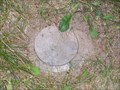 view gallery view galleryNW42.6 km |  QM0551 (A227) Vertical Control Mark QM0551 (A227) Vertical Control Mark
in U.S. Benchmarks A227 Vertical Control Mark next to Laona School Forest Historical Marker. posted by: frankhj location: Wisconsin date approved: 08/14/2007 last visited: 04/30/2013 |
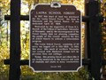 view gallery view galleryNW42.6 km | Laona School Forest in Wisconsin Historical Markers Loaona School Forest Marker S. of Laona. posted by: frankhj location: Wisconsin date approved: 08/13/2007 last visited: 04/30/2013 |
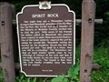 view gallery view gallery SW42.8 km SW42.8 km
| Spirit Rock in Wisconsin Historical Markers Spirit Rock Marker N. of Keshena. posted by: frankhj location: Wisconsin date approved: 08/13/2007 last visited: 05/09/2023 |
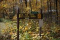 view gallery view galleryW43.5 km |  Ice Age Trail - Langlade County Ice Age Trail - Langlade County
in Ice Age Trail Trailhead sign for the Kettlebowl Segment posted by: The Troops location: Wisconsin date approved: 10/14/2012 last visited: 05/18/2017 |
 view gallery view galleryNE43.5 km | Buhl Falls - Marinette County, WI in Waterfalls Buhl Falls in Marinette County, Wisconsin. posted by: Team B Squared location: Wisconsin date approved: 01/27/2009 last visited: never |
 view gallery view galleryW43.9 km | Old Military Road in Wisconsin Historical Markers Old Military Road Marker N. of Lily. posted by: frankhj location: Wisconsin date approved: 07/22/2007 last visited: 09/26/2014 |
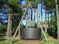 view gallery view galleryNW44.1 km |  Soup Kettle Soup Kettle
in Ginormous Everyday Objects Worlds largest soup kettle in Laona, WI. posted by: tiki-4 location: Wisconsin date approved: 10/15/2005 last visited: 04/30/2013 |
 view gallery view gallerySE47.3 km |  Halfway North, US41, WI Halfway North, US41, WI
in U.S. Historic Survey Stones and Monuments Halfway North Marker along US41 in Oconto County, WI. posted by: frankhj location: Wisconsin date approved: 08/14/2007 last visited: 04/28/2023 |
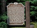
 view gallery view gallerySW48 km | Menominee Reservation in Wisconsin Historical Markers Menominee Reservation Marker S. of Keshena. posted by: frankhj location: Wisconsin date approved: 07/22/2007 last visited: 07/13/2011 |
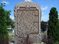 view gallery view gallerySE51 km | Peshtigo Fire Cemetery in Wisconsin Historical Markers Peshtigo Fire Cemetary Marker in Peshtigo. #1 on the list of Wisconsin Official Historical Markers. There are numerous story cards scattered throughout the cemetery. posted by: frankhj location: Wisconsin date approved: 08/13/2007 last visited: 07/19/2017 |
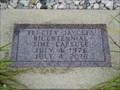 view gallery view gallerySE51 km |  Peshtigo Tri-City Jaycees Bicentennial Time Capsule Peshtigo Tri-City Jaycees Bicentennial Time Capsule
in Time Capsules Peshtigo Tri-City Jaycees Bicentennial Time Capsule in Peshtigo, WI. posted by: frankhj location: Wisconsin date approved: 08/10/2007 last visited: 03/06/2019 |
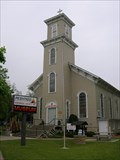 view gallery view gallerySE51 km |  Peshtigo Fire Museum Peshtigo Fire Museum
in Wikipedia Entries Excellent museum detailing the events of the worst fire in US History in the Pestigo, WI area on Oct 8, 1871. The cemetery next to the museum is also very interesting. posted by: Cruiseologist location: Wisconsin date approved: 06/09/2008 last visited: 05/08/2018 |
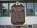 view gallery view galleryE51.2 km | McAllister State Graded School in Wisconsin Historical Markers McAllister State Graded School Marker in McAllister. The address on the list is W2349, but it is actually W2379. posted by: frankhj location: Wisconsin date approved: 08/13/2007 last visited: never |
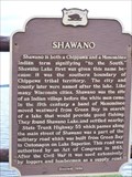 view gallery view gallery S52.1 km S52.1 km
| Shawano in Wisconsin Historical Markers "To the South" posted by: jcak1979 location: Wisconsin date approved: 04/24/2006 last visited: 01/17/2011 |
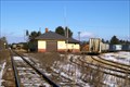 view gallery view galleryNE52.1 km |  Union Depot - Pembine, Wisconsin Union Depot - Pembine, Wisconsin
in Train Stations/Depots Union Depot - Pembine, Wisconsin posted by: kJfishman location: Wisconsin date approved: 01/18/2013 last visited: 01/18/2013 |
|