 view gallery view gallery NW10.1 km NW10.1 km
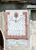
|   Zarbula 1833 Balboutel, Italy Zarbula 1833 Balboutel, Italy
in Sundials Two sundials in Balboutel, Piemonte, Italy are attributed to Zarbula. posted by:  arby101ca arby101ca location: Piemonte, Italy date approved: 01/14/2010 last visited: never |
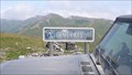
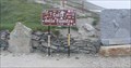 view gallery view gallery N10.5 km N10.5 km
|  Colle delle Finestre - Piemont, Turin, Italy. 2176m Colle delle Finestre - Piemont, Turin, Italy. 2176m
in Elevation Signs This region is a highlight not only for 4x4 drivers posted by:  g300td g300td location: Piemonte, Italy date approved: 12/10/2014 last visited: 08/25/2013 |
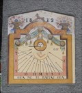
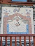
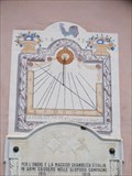 view gallery view galleryNW12.1 km | Zarbula 1872 Sundials, Soucheres Basses, Italy in Sundials Zarbula painted two similar sundials on the chapel in Soucheres Basses, a hamlet in Pragelato, Val Chisone, Piemonte, Italy. posted by: arby101ca location: Piemonte, Italy date approved: 01/16/2010 last visited: never |
 view gallery view gallery W14.5 km W14.5 km
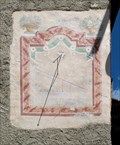
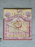
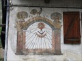
| Zarbula 1872 Sundial, Villarmond, Italy in Sundials A faded original Zarbula sundial painted in 1872 on a house in the hamlet of Villarmond, Pragelato, Piemonte, Italy posted by: arby101ca location: Piemonte, Italy date approved: 01/16/2010 last visited: never |
 view gallery view galleryW15.9 km | Monte Genevris - Piemont, Turin, Italy. 2536m. in Elevation Signs Elevation sign at the Assietta strada posted by: g300td location: Piemonte, Italy date approved: 12/10/2014 last visited: never |
 view gallery view galleryW16.1 km | Zarbula 1872 Sundial: Borgata 14, Sestriere, Italy in Sundials There are three sundials by Zarbula in 1872 in Borgata Sestriere, Piemonte, Italy. posted by: arby101ca location: Piemonte, Italy date approved: 01/18/2010 last visited: never |
 view gallery view galleryW16.1 km | Zarbula 1872 Sundial: Borgata 12, Sestriere, Italy in Sundials There are three sundials by Zarbula in 1872 in Borgata Sestriere, Piemonte, Italy. This one has been repainted reasonably well. posted by: arby101ca location: Piemonte, Italy date approved: 01/18/2010 last visited: never |
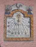 view gallery view galleryW16.1 km | Zarbula 1872: Borgata Sestriere 20, Italy in Sundials This original Zarbula sundial is the best of the three he painted in 1872 in Borgata Sestriere, Val Chisone, Piemonte, Italy posted by: arby101ca location: Piemonte, Italy date approved: 01/19/2010 last visited: never |
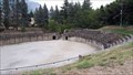 view gallery view galleryN17.2 km |  Roman Arena - Susa, Italy Roman Arena - Susa, Italy
in Ancient Roman Civilization The Roman Arena in Susa is situated south of the city, along the route of the Gauls. This route passed underneath the Arch of Augustus, and the arcades of the aqueduct and continued up the valley to Mons Matrona (Monginevro). posted by: RakeInTheCache location: Piemonte, Italy date approved: 09/15/2019 last visited: never |
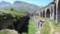
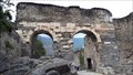 view gallery view galleryN17.5 km | Roman Aqueduct - Susa, Italy in Ancient Roman Civilization Adjacent to the city wall, arches support a part of a Roman aqueduct. posted by: RakeInTheCache location: Piemonte, Italy date approved: 09/15/2019 last visited: never |
 view gallery view galleryN17.5 km |  Roman Aqueduct - Susa, Italy Roman Aqueduct - Susa, Italy
in Ancient Aqueducts Adjacent to the city wall, arches support a part of a Roman aqueduct. posted by: RakeInTheCache location: Piemonte, Italy date approved: 11/21/2019 last visited: never |
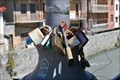 view gallery view galleryN17.5 km |  Love Padlocks - Susa, Italy Love Padlocks - Susa, Italy
in Love Padlocks Love Padlocks sul ponte della strada lampione Susa Mazzini. posted by: Team Glandouillage location: Piemonte, Italy date approved: 01/16/2016 last visited: 01/16/2016 |
 view gallery view galleryN17.5 km | Le Castrum - Susa, Italy in Ancient Roman Civilization The castrum was the Roman fortress of Segusio, today the town of Susa. Segusio was founded by the Gauls. In the late 1st century BC it became voluntarily part of the Roman Empire. posted by: RakeInTheCache location: Piemonte, Italy date approved: 10/15/2019 last visited: never |
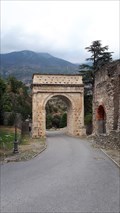 view gallery view galleryN17.5 km | Arch of Augustus - Susa, Italy in Ancient Roman Civilization The Arch of Augustus was originally built at the end of the 1st century BC to record the renewed alliance between Emperor Augustus andMarcus Julius Cottius, a Celto-Ligurian ruler who had been made king and Roman prefect of the Cottian Alps. posted by: RakeInTheCache location: Piemonte, Italy date approved: 09/13/2019 last visited: never |
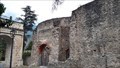
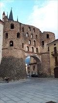 view gallery view galleryN17.7 km | Porta Savoia - Susa, Italy in Ancient Roman Civilization The Savoy Gate was one of the main gates of the city of Susa and is a fine example of Roman military architecture in the Susa Valley. posted by: RakeInTheCache location: Piemonte, Italy date approved: 09/15/2019 last visited: never |
 view gallery view galleryW19.8 km | Zarbula 1870 Sundial, Champlas du Col, Italy in Sundials Replacement by Morra of the 1870 Zarbula sundial on Casa Cantele, 7 Via Nazionale, Champlas du Col, Sestriere, Val Chisone, Italy posted by: arby101ca location: Piemonte, Italy date approved: 01/05/2010 last visited: never |
 view gallery view galleryW20 km | Zarbula Sundial1870: Champlas du Col, Italy in Sundials In 1870 Zarbula painted a sundial and Black Madonna on a large house on the main street of Champlas du Col, Val Chisone, Piemonte, Italy posted by: arby101ca location: Piemonte, Italy date approved: 11/21/2009 last visited: never |
 view gallery view galleryW21.7 km | Zarbula 1871 Sundials: Rollieres, Italy in Sundials On the Chapel in the hamlet of Rollieres, Sauze di Cesana, Piemonte, Italy are a pair of sundials attributed to Zarbula posted by: arby101ca location: Piemonte, Italy date approved: 01/07/2010 last visited: never |
 view gallery view gallery NE23 km NE23 km
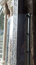
|  Sacra di San Michele - Val di Susa, Italy Sacra di San Michele - Val di Susa, Italy
in Romanesque Architecture The Sacra di San Michele is a religious complex on Mount Pirchiriano. The church has a nave and two aisles, and features elements of both Gothic and Romanesque architecture. posted by: RakeInTheCache location: Piemonte, Italy date approved: 09/17/2019 last visited: never |
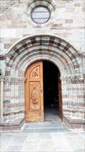
 view gallery view galleryNE23 km |  The Portal of the Zodiac - Sacra di San Michele, Val di Susa, Italy The Portal of the Zodiac - Sacra di San Michele, Val di Susa, Italy
in Signs of Zodiac The Great Staircase of the Dead ends at the Portal of the Zodiac (1128-30), a Romanesque work carved by Master Nicolao, a famous architect and sculptor from Piacenza. posted by: RakeInTheCache location: Piemonte, Italy date approved: 09/20/2019 last visited: never |
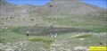
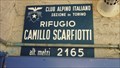 view gallery view galleryNW28.6 km | Rifugio Scarfiotti - Elevation-Sign, Bardonecchia, Italy. 2165m in Elevation Signs This is an alpine refuge in Valle di Rochemolles posted by: g300td location: Piemonte, Italy date approved: 12/01/2014 last visited: 08/27/2013 |
 view gallery view galleryW29.3 km |  Lac Noir - Cervières, France Lac Noir - Cervières, France
in Natural Lakes Le lac Noir (2 226 m) se situe dans la vallée de la Cerveyrette au-dessus du village de Cervières (Briançonnais, Hautes-Alpes). Lac Noir (2,226 m) is located in the Cerveyrette Valley. posted by: YvesProvence location: Provence-Alpes-Côte d'Azur, France date approved: 03/07/2018 last visited: never |
 view gallery view galleryW29.3 km | Lac du Rouséou - Cervières, France in Natural Lakes Petit lac juste au dessus du lac Noir et sous les sommets du Chenaillet (2650m) et du Grand Charvia (2648m) / Small lake just above Black Lake posted by: YvesProvence location: Provence-Alpes-Côte d'Azur, France date approved: 03/07/2018 last visited: never |
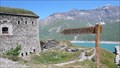 view gallery view galleryNW29.6 km | Fort de Variselle - Lanslebourg-Mont-Cenis, France. 2100 M. in Elevation Signs The sign in front of the fort posted by: g300td location: Auvergne-Rhône-Alpes, France date approved: 12/11/2014 last visited: 08/09/2011 |
 view gallery view galleryNW29.6 km |  Fort de Variselle - Lanslebourg-Mont-Cenis, France. Fort de Variselle - Lanslebourg-Mont-Cenis, France.
in Preserved Architectural Remnants and Ruins Fort de Variselle above Lake Mont Cenis posted by: g300td location: Auvergne-Rhône-Alpes, France date approved: 12/11/2014 last visited: never |
|