 view gallery view gallery NW20.1 km NW20.1 km
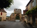
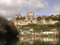
|   Remparts - Domme,France Remparts - Domme,France
in Monuments Historiques Français les remparts de la ville de DOMME. posted by:  sara et gege sara et gege location: Nouvelle-Aquitaine, France date approved: 06/08/2017 last visited: 09/02/2018 |
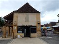
 view gallery view galleryNW20.3 km |  Ghost sign of the inn "A la Samaritaine" - Cénac-et-Saint-Julien, 24, FRA Ghost sign of the inn "A la Samaritaine" - Cénac-et-Saint-Julien, 24, FRA
in Ghost Signs At Cénac-et-Saint-Julien, the advertising sign from the 19th century of an old "auberge" is still readable at this long converted building. posted by: André de Montbard location: Nouvelle-Aquitaine, France date approved: 11/29/2020 last visited: never |
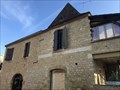
 view gallery view galleryNW20.3 km | Halle office de tourisme - Domme,France in Monuments Historiques Français ancienne Halle devenue l'office de tourisme et l'entrée des grottes. posted by: sara et gege location: Nouvelle-Aquitaine, France date approved: 06/08/2017 last visited: 09/02/2018 |
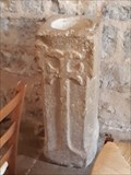
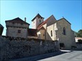
 view gallery view galleryNW20.3 km |  repere geodesique DOMME III repere geodesique DOMME III
in French Benchmarks le clocher de l'eglise posted by: sara et gege location: Nouvelle-Aquitaine, France date approved: 06/07/2017 last visited: 09/02/2018 |
 view gallery view gallery E20.4 km E20.4 km
|  Bénitier dans L’église Sainte-Madeleine - Soulomès (Lot), France Bénitier dans L’église Sainte-Madeleine - Soulomès (Lot), France
in Stone Church Artefacts [FR] Ce bénitier du 16e siècle est taillé dans un seul bloc de pierre de section carré. [EN] This 16th century baptismal font is carved from a single square block of stone. posted by: RakeInTheCache location: Occitanie, France date approved: 11/06/2020 last visited: never |
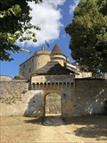
 view gallery view galleryE20.4 km |  Commanderie Hospitalière - Soulomès (Lot), France Commanderie Hospitalière - Soulomès (Lot), France
in Legacy of Medieval Spiritual Warriors [FR] En 1258 Soulomès (Solomo) devient le membre principal de la commanderie des Hospitaliers d’Espédaillac, puis de Durbans. [EN] In 1258, Soulomès (Solomo) became the principal member of the Hospitaler commandery of Espédaillac, and then Durbans. posted by: RakeInTheCache location: Occitanie, France date approved: 10/24/2020 last visited: never |
 view gallery view gallery N22.2 km N22.2 km
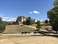
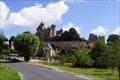
| Château de Fénelon - Dordogne, FRA in Monuments Historiques Français Le château de Fénelon, classé monument historique, est situé dans le département de la Dordogne au centre du triangle formé par les villes de Sarlat, Souillac et Gourdon. posted by: André de Montbard location: Nouvelle-Aquitaine, France date approved: 09/20/2018 last visited: never |
 view gallery view galleryN22.2 km |  Château de Fénelon - Dordogne, FRA Château de Fénelon - Dordogne, FRA
in Castles The Fénelon castle in the Dordogne département in the Périgord countryside is one of the best preserved castles in France. The building complex has been recognized as a monument historique since 1927 (in parts since 1962). posted by: André de Montbard location: Nouvelle-Aquitaine, France date approved: 09/20/2018 last visited: never |
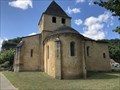 view gallery view galleryN22.5 km | Eglise Saint-Caprais de Carsac - Dordogne, FRA in Monuments Historiques Français Eglise roman dans le Vallé de Dordogne. posted by: André de Montbard location: Auvergne-Rhône-Alpes, France date approved: 09/22/2018 last visited: 07/03/2022 |
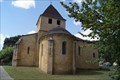 view gallery view galleryN22.5 km |  Eglise Saint-Caprais de Carsac - Dordogne, FRA Eglise Saint-Caprais de Carsac - Dordogne, FRA
in Romanesque Architecture Romanesque Church in the Dordogne Valley build in the 11th century, nearly pure romanesque with early gothic additions. Most of the building is pure 11th century. posted by: André de Montbard location: Nouvelle-Aquitaine, France date approved: 09/22/2018 last visited: 07/03/2022 |
 view gallery view galleryNW22.7 km |  The Dordogne - La Roque-Gageac to Bezenac The Dordogne - La Roque-Gageac to Bezenac
in Canoe/Kayak Trips This stretch of the Dordogne river in Southwest France makes for what must be one of the most beautiful short canoe excursions in the world. posted by: RakeInTheCache location: Nouvelle-Aquitaine, France date approved: 01/05/2007 last visited: 10/09/2022 |
 view gallery view galleryN22.7 km | Château de Montfort - Dordogne, FRA in Castles The Château de Montfort is a castle in the French commune of Vitrac in the Dordogne département, part of the region of Nouvelle-Aquitaine. posted by: André de Montbard location: Nouvelle-Aquitaine, France date approved: 09/22/2018 last visited: never |
 view gallery view gallery S22.7 km S22.7 km
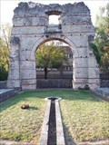
|  Arc de Diane - Cahors, France Arc de Diane - Cahors, France
in Ancient Roman Civilization [FR] L'Arc de Diane est le principal vestige des thermes romains de Divona Cadurcorum, la cité gallo-romaine. [EN] The Arch of Diana is the main vestige of the Roman baths of Divona Cadurcorum, the Gallo-Roman city that became Cahors. posted by: RakeInTheCache location: Occitanie, France date approved: 11/01/2020 last visited: never |
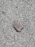
 view gallery view galleryS22.9 km |  Way Marker Le Jardin de Saint Jacques - Cahors, France Way Marker Le Jardin de Saint Jacques - Cahors, France
in Way of St. James [FR] Ce jardin rend hommage aux pèlerins qui empruntent les 770 km de la Via Podensis du Puy-en-Velay à Roncevaux. [EN] This garden pays homage to the pilgrims who follow the 770 km of the Via Podensis from Puy-en-Velay to Roncevaux. posted by: RakeInTheCache location: Occitanie, France date approved: 11/01/2020 last visited: never |
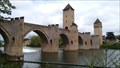 view gallery view galleryS23.2 km |  Pont Valentré, Cahors Pont Valentré, Cahors
in Arch Bridges The iconic Pont Valentré is the signature for the city of Cahors and the surrounding vineyards. This stone arched bridge, fortified with three towers, is classic example of medieval French military architecture, a National Historical Monument. posted by:  arby101ca arby101ca location: France date approved: 08/11/2015 last visited: 08/24/2022 |
 view gallery view galleryS23.2 km |  Chemins de Saint-Jacques-de-Compostelle en France -Pont Valentré, Cahors Chemins de Saint-Jacques-de-Compostelle en France -Pont Valentré, Cahors
in World Heritage Sites The iconic Pont Valentré is the signature for the city of Cahors and the surrounding vineyards. This stone arched bridge, fortified with three towers, is classic example of medieval French military architecture and UNESCO world heritage site,868-052. posted by: arby101ca location: Occitanie, France date approved: 08/10/2015 last visited: 08/24/2022 |
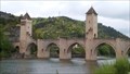 view gallery view galleryS23.2 km | Pont Valentré - Cahors, France in Monuments Historiques Français The iconic Pont Valentré is the signature for the city of Cahors and the surrounding vineyards. This stone arched bridge, fortified with three towers, is classic example of medieval French military architecture, a National Historical Monument. posted by: arby101ca location: Occitanie, France date approved: 08/11/2015 last visited: 08/24/2022 |
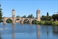 view gallery view galleryS23.3 km |  Pont Valentré - Cahors, Midi-Pyrénées, France Pont Valentré - Cahors, Midi-Pyrénées, France
in Gothic Architecture Pont Valentré took over 70 years to build in the 14th century. // Pont Valentré a pris plus de 70 ans pour construire au 14ème siècle. posted by: Trail Blaisers location: Occitanie, France date approved: 09/06/2017 last visited: 08/24/2022 |
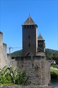 view gallery view galleryS23.3 km |  Devil's Tower- Cahors, Midi-Pyrénées, France Devil's Tower- Cahors, Midi-Pyrénées, France
in Man-made Devilish Locations The bridge's central tower is named Devil's Tower for the apparent role that the devil played in getting the bridge finished. // La tour centrale du pont s'appelle Devil's Tower pour le rôle apparent que le diable a joué dans la fin du pont. posted by: Trail Blaisers location: Occitanie, France date approved: 09/03/2017 last visited: 04/03/2023 |
 view gallery view galleryS23.3 km |  Pont Valentré - Cahors, Midi-Pyrénées, France Pont Valentré - Cahors, Midi-Pyrénées, France
in Urban Legends and Superstitions Legend has it that the bridge's builder made a deal with the devil to speed up the pace of construction. // Selon la légende, le constructeur de ponts a fait un accord avec le diable pour accélérer le rythme de la construction. posted by: Trail Blaisers location: Occitanie, France date approved: 09/08/2017 last visited: 08/24/2022 |
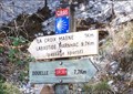 view gallery view galleryS23.3 km | Way Marker GR 65 La via Podiensis - Cahors, France in Way of St. James [FR] La via Podiensis, la "Route du Puy" est la plus célèbre et la plus populaire, car au plus près de la réalité historique. [EN] The French name for this GR route is the Chemin de Saint-Jacques. posted by: RakeInTheCache location: Occitanie, France date approved: 11/01/2020 last visited: never |
 view gallery view galleryS23.3 km | Way Marker Pont Valentré - Cahors, France in Way of St. James [FR] Cahors est une étape incontournable sur la voie principale du chemin de Saint-Jacques de Compostelle, la Via Podiensis. [EN] Cahors is crossed by the Via Podiensis, the route from Puy en Velay, today called the Grande Randonnée route GR65. posted by: RakeInTheCache location: Occitanie, France date approved: 10/28/2020 last visited: never |
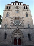
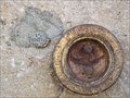 view gallery view galleryS23.3 km | Cathédrale St Etienne CAHORS - 46 in French Benchmarks Cathédrale St Etienne CAHORS - 46
Borne du Nivellement Général de France altitude 124,74 m posted by: Gulliver D. location: Occitanie, France date approved: 08/27/2017 last visited: 08/24/2022 |
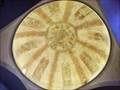 view gallery view galleryS23.3 km |  World") Cathédrale Saint-Etienne - Cahors.France Cathédrale Saint-Etienne - Cahors.France
in Domes of the (Under) World Un des 2 domes de la cathedrale de Cahors posted by: lulu_et_compagnie location: Occitanie, France date approved: 10/27/2018 last visited: 08/24/2022 |
 view gallery view galleryS23.3 km | Cathédrale Saint-Étienne - Cahors, France in Romanesque Architecture [FR] La cathédrale Saint-Étienne est une cathédrale gothique, romane et byzantine édifiée au début du xiie siècle. [EN] Cahors Cathedral is an example of the transition between the late Romanesque and Gothic architectural traditions. posted by: RakeInTheCache location: Occitanie, France date approved: 10/29/2020 last visited: 08/24/2022 |
|