 view gallery view gallery SW12.9 km SW12.9 km
|   Six Nations Museum - Onchiota, NY Six Nations Museum - Onchiota, NY
in History Museums This museum is on Route 60 just outside the gate of the Buck Pond DEC campsite (to the east of the campground) in Onchiota, NY (North of Rainbow Lake) posted by:  sagefemme sagefemme location: New York date approved: 08/11/2014 last visited: never |
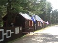
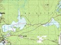
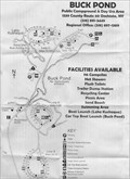 view gallery view gallerySW13.4 km |  Buck Pond DEC - Onchiota, NY Buck Pond DEC - Onchiota, NY
in Campgrounds Buck Pond Campground is near the end of County Rt 60 off NYS Rt 30 north of Saranac Lakes. posted by: sagefemme location: New York date approved: 08/22/2013 last visited: 08/23/2013 |
 view gallery view gallery NE17.5 km NE17.5 km
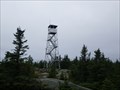
|  Lyon Mt. Fire Tower - NY, USA Lyon Mt. Fire Tower - NY, USA
in Look-Out Towers This lookout tower lays top of Mt. Lyon in the Adirondacks. posted by: tatie location: New York date approved: 03/25/2012 last visited: 10/19/2007 |
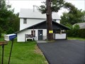 view gallery view gallerySW18.3 km |  Rainbow Lake, NY 12976 Rainbow Lake, NY 12976
in U.S. Post Offices Located at 555 County Route 60, Rainbow Lake, NY 12976 posted by: nomadwillie location: New York date approved: 03/02/2012 last visited: 08/09/2014 |
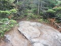
 view gallery view gallerySW20.3 km |  Jones Pond to Osgood Pond to Church Pond Jones Pond to Osgood Pond to Church Pond
in Canoe/Kayak Trips A nice paddle through some lovely country in the Adirondacks in Northern NY. posted by: nfa location: New York date approved: 08/21/2006 last visited: 10/14/2011 |
 view gallery view gallery SE24.3 km SE24.3 km
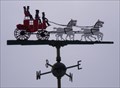
|  Coach and Four - Wilmington, NY Coach and Four - Wilmington, NY
in Unique Weathervanes This 19th-century theme weathervane is located atop the gate house for the Veteran's Memorial Highway, which ascends Whiteface Mountain. posted by:  Telomere Telomere location: New York date approved: 12/01/2009 last visited: 09/15/2016 |
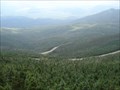 view gallery view gallerySE24.3 km |  New York State World War Memorial Highway - Wilmington, NY New York State World War Memorial Highway - Wilmington, NY
in American Guide Series New York State World War Memorial Highway winds its way up Whiteface Mountain from NY Route 431 west of Wilmington, NY. posted by: Lightnin Bug location: New York date approved: 09/18/2010 last visited: 08/09/2015 |
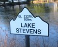 view gallery view gallerySE24.3 km |  Lake Stevens - 2327 feet - Wilmington, NY Lake Stevens - 2327 feet - Wilmington, NY
in Elevation Signs Lake Stevens is located near the Toll House at the Whiteface Veterans Memorial Highway in Wilmington, NY. posted by: denben location: New York date approved: 11/07/2012 last visited: 05/18/2014 |
 view gallery view gallery S24.5 km S24.5 km
| Moose Pond Campsite and Picnic and Fishing Spot in Free Campsites A sweet camping spot on Moose Pond, near Bloomingdale, NY. posted by: nfa location: New York date approved: 06/18/2006 last visited: 09/27/2012 |
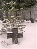 view gallery view gallerySW24.8 km |  Edward Trudeau - Paul Smiths, NY Edward Trudeau - Paul Smiths, NY
in Grave of a Famous Person Grave of Edward Livingston Trudeau, pioneer in the study, care and treatment of tuberculosis. posted by: hykesj location: New York date approved: 08/03/2022 last visited: never |
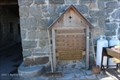
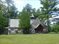 view gallery view gallerySW24.8 km |  St. John's in the Wilderness Episcopal Church St. John's in the Wilderness Episcopal Church
in This Old Church St. John's in the Wilderness Episcopal Church is located near Church Pond at Paul Smith's, on State Route 86, close to the intersection with Route 30. posted by: polecat42 location: New York date approved: 07/01/2014 last visited: 06/23/2014 |
 view gallery view gallerySE25.4 km |  Esther Mountain - Adirondack State Park, NY Esther Mountain - Adirondack State Park, NY
in Mountain Summits Esther Mountain is the 28th highest of the 46 High Peaks in the Adirondacks. posted by: sagefemme location: New York date approved: 07/15/2016 last visited: never |
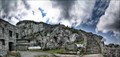 view gallery view galleryS27 km | Elevator and Staircase to Summit - Wilmington, NY in American Guide Series Whiteface Castle, built with granite excavated during the road construction, dominates the summit area. From the adjacent parking lot there are two routes to the summit proper. posted by: nomadwillie location: New York date approved: 12/09/2022 last visited: never |
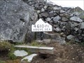 view gallery view galleryS27 km | Whiteface Mountain Castle - 4610 ft - Wilmington, NY in Elevation Signs At the end of the Whiteface Mountain Memorial Highway, you come upon this elevation sign. posted by: Lightnin Bug location: New York date approved: 09/03/2010 last visited: 06/02/2019 |
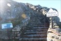 view gallery view galleryS27 km |  Whiteface Nature Trail Stairs to Summit - Wilmington, NY Whiteface Nature Trail Stairs to Summit - Wilmington, NY
in Outdoor Stairways This steady but uneven climb ascends to the summit of Whiteface Mountain from the terminus of the Veterans Memorial Highway. posted by: NorStar location: New York date approved: 12/31/2016 last visited: 07/13/2017 |
 view gallery view galleryS27 km |  Veterans Memorial Highway War Monument, Whiteface Mountain - Wilmington, NY Veterans Memorial Highway War Monument, Whiteface Mountain - Wilmington, NY
in Non-Specific Veteran Memorials This monument was added to rededicate the drive up Whiteface Mountain from World War (I) veterans to veterans of all wars. posted by: NorStar location: New York date approved: 12/31/2016 last visited: 07/13/2017 |
 view gallery view galleryS27 km |  Whiteface Mountain Nature Trail - Wilmington, NY Whiteface Mountain Nature Trail - Wilmington, NY
in Self Guided Walks and Trails This trail with descriptive signs from the 'castle' building to the summit of Whiteface is one of the most rugged nature trails you could walk on. posted by: NorStar location: New York date approved: 01/02/2017 last visited: 07/13/2017 |
 view gallery view galleryS27 km | Whiteface Mountain Bivouac Site in Free Campsites Bivouac site can be seen from the Whiteface Mountain trail. posted by: sagefemme location: New York date approved: 06/10/2014 last visited: never |
 view gallery view galleryS27.2 km | Whiteface Mountain in Mountain Summits Easily accessible via Toll-Highway/elevator or a Gondola Ride. posted by: bubba007 location: New York date approved: 08/22/2007 last visited: 06/02/2019 |
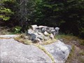
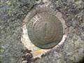
 view gallery view galleryS27.2 km |  Whiteface Mountain No1 Reference Marker Whiteface Mountain No1 Reference Marker
in U.S. Benchmarks One of two brass survey disks atop Whiteface Mountain. This survey disk is east of an observation deck/platform on the south side of the Atmospheric Research Center at the top of Whiteface Mt. posted by: sagefemme location: New York date approved: 06/16/2014 last visited: 09/15/2016 |
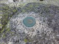
 view gallery view galleryS27.2 km | Whiteface Mt No. 2 Reference Marker in U.S. Benchmarks One of two brass survey disks atop Whiteface Mountain. This survey disk is just north of an observation deck/platform on the south side of the Atmospheric Research Center at the top of Whiteface Mt. posted by: sagefemme location: New York date approved: 06/10/2014 last visited: 09/15/2016 |
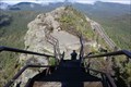
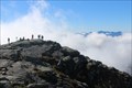 view gallery view galleryS27.2 km |  Mt. Whiteface Summit - Wilmington, NY Mt. Whiteface Summit - Wilmington, NY
in Web Cameras This web cam overlooks the southeastern edge of the Mt. Whiteface Summit in the foreground and the High Peaks of the Adirondacks in the background from the weather station at its peak. posted by: NorStar location: New York date approved: 01/27/2017 last visited: never |
 view gallery view galleryS27.2 km |  The ASRC Whiteface Mountain Field Station - Wilmington, NY The ASRC Whiteface Mountain Field Station - Wilmington, NY
in Weather Stations The field station on top of Whiteface Mountain is in a three-story building and takes measurements on the summit of Whiteface Mountain by the Atmospheric Sciences Research Center of SUNY at Albany. posted by: NorStar location: New York date approved: 10/12/2016 last visited: never |
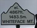 view gallery view galleryS27.2 km | Whiteface Mountain - New York 4,867 feet in Elevation Signs The summit of Whiteface Mountain is the only one of the Adirondack High Peaks accessible by auto. posted by: MrsMcFly location: New York date approved: 08/29/2007 last visited: 06/02/2019 |
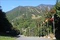 view gallery view galleryS27.2 km | Whiteface Mountain - Wilmington, NY in American Guide Series From its summit, accessible by going up a serpentine road - the New York State World War Memorial Highway - then either an elevator or trail, almost the entire northern part of the State is visible. posted by: NorStar location: New York date approved: 12/31/2016 last visited: 11/19/2019 |
|