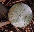
 view gallery view gallery SE0.5 km SE0.5 km
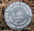
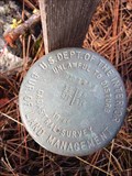
|   T13S R9E S10 15 1/4 COR - Jefferson County, OR T13S R9E S10 15 1/4 COR - Jefferson County, OR
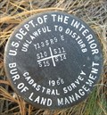
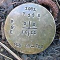
in Public Land Survey Marks PLSS quarter corner set by USDI-Bureau of Land Management in a 1966 cadastral survey; National Forest Survey Corner Visitation Card, Index File No. 1559 posted by:  Cooke17513 Cooke17513 location: Oregon date approved: 11/14/2013 last visited: never |
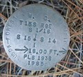
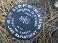
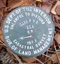 view gallery view gallery SW0.6 km SW0.6 km
| T13S R9E S9 10 16 15 COR S10 RM - Jefferson County, OR in Public Land Survey Marks PLSS reference monument set by USDI-Bureau of Land Management in a 1966 cadastral survey; National Forest Survey Corner Visitation Card, Index File No. 1359 posted by: Cooke17513 location: Oregon date approved: 11/14/2013 last visited: never |
 view gallery view gallery NW0.6 km NW0.6 km
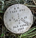
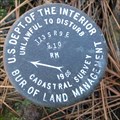
| T13S R9E S9 10 1/4 COR S10 RM - Jefferson County, OR in Public Land Survey Marks PLSS reference monument set by USDA-Forest Service, Fred Ast in 1985; National Forest Survey Corner Visitation Card, Index File No. 1357 posted by: Cooke17513 location: Oregon date approved: 11/19/2013 last visited: never |
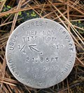
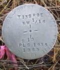 view gallery view gallery N0.8 km N0.8 km
| T13S R9E S10 NW 1/16 COR - Jefferson County, OR in Public Land Survey Marks PLSS sixteenth corner set by USDA-Forest Service, Fred Ast in 1985; National Forest Survey Corner Visitation Card, Index File No. 1456 posted by: Cooke17513 location: Oregon date approved: 11/19/2013 last visited: never |
 view gallery view galleryN1 km | T13S R9E S10 N 1/16 COR RM - Jefferson County, OR in Public Land Survey Marks PLSS reference monument set by USDA-Forest Service, Fred Ast in 1985; National Forest Survey Corner Visitation Card, Index File No. 1556 posted by: Cooke17513 location: Oregon date approved: 11/19/2013 last visited: never |
 view gallery view gallery E1.1 km E1.1 km
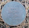
| T13S R9E S10 11 15 14 COR - Jefferson County, OR in Public Land Survey Marks PLSS section corner set by USDI-Bureau of Land Management in 1966;
National Forest Survey Corner Visitation Card, Index File No. 1759 posted by: Cooke17513 location: Oregon date approved: 10/23/2013 last visited: never |
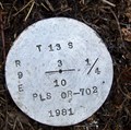
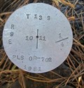 view gallery view galleryE1.1 km | T13S R9E S10 11 1/4 COR - Jefferson County, OR in Public Land Survey Marks PLSS quarter corner set by USDA-Forest Service, R. Oman in 1981; National Forest Survey Corner Visitation Card, Index File No. 1757 posted by: Cooke17513 location: Oregon date approved: 10/28/2013 last visited: never |
 view gallery view gallery S1.3 km S1.3 km
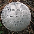
| T13S R9E S15 C 1/4 COR - Jefferson County, OR in Public Land Survey Marks PLSS center quarter corner set by USDA-Forest Service, Fred Ast in 1985; National Forest Survey Corner Visitation Card, Index File No. 1561 posted by: Cooke17513 location: Oregon date approved: 11/12/2013 last visited: 05/03/2016 |
 view gallery view galleryN1.3 km | T13S R9E S3 10 1/4 COR - Jefferson County, OR in Public Land Survey Marks PLSS quarter corner set by USDA-Forest Service, R. Oman in 1981; National Forest Survey Corner Visitation Card, Index File No. 1555 posted by: Cooke17513 location: Oregon date approved: 11/17/2013 last visited: never |
 view gallery view galleryN1.3 km | T13S R9E S4 3 9 10 COR S10 RM - Jefferson County, OR in Public Land Survey Marks PLSS reference monument set by USDI-Bureau of Land Management, J.E. Jelley in a 1966 cadastral survey; National Forest Survey Corner Visitation Card, Index File No. 1355 posted by: Cooke17513 location: Oregon date approved: 11/17/2013 last visited: never |
 view gallery view galleryS1.3 km | T13S R9E S16 15 1/4 COR S15 RM - Jefferson County, OR in Public Land Survey Marks PLSS reference monument set by USDI-Bureau of Land Management in a 1966 cadastral survey; National Forest Survey Corner Visitation Card, Index File No. 1361 posted by: Cooke17513 location: Oregon date approved: 11/14/2013 last visited: never |
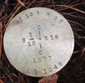
 view gallery view gallery W1.3 km W1.3 km
| T13S R9E S9 16 1/4 COR - Jefferson County, OR in Public Land Survey Marks PLSS quarter corner remonumented by USDI-Bureau of Land Management, James E. Jelley in 1966; National Forest Survey Corner Visitation Card, Index File No. 1159 posted by: Cooke17513 location: Oregon date approved: 05/13/2016 last visited: never |
 view gallery view gallerySW1.4 km | T13S R9E S16 C-W-W-NE 1/256 COR - Jefferson County, OR in Public Land Survey Marks PLSS 256th corner set by Michail W. Tye in 1977; Land Corner Record T13S R9E K-11½ posted by: Cooke17513 location: Oregon date approved: 05/14/2016 last visited: never |
 view gallery view gallerySW1.4 km | T13S R9E S16 N 1/6 COR - Jefferson County, OR in Public Land Survey Marks PLSS sixteenth corner remonumented by Sun Country Engineering & Surveying, Robert M. Karl in 1977; National Forest Survey Corner Visitation Card, Index File No.1160 posted by: Cooke17513 location: Oregon date approved: 05/14/2016 last visited: never |
 view gallery view galleryS1.6 km | T13S R9E S15 S 1/16 COR - Jefferson County, OR in Public Land Survey Marks PLSS sixteenth corner set by USDA-Forest Service, Fred Ast in 1985; National Forest Survey Corner Visitation Card, Index File No. 1562 posted by: Cooke17513 location: Oregon date approved: 11/12/2013 last visited: never |
 view gallery view gallerySE1.6 km | T13S R9E S15 14 1/4 COR - Jefferson County, OR in Public Land Survey Marks PLSS quarter corner set by USDA-Forest Service, Fred Ast in 1985; National Forest Survey Corner Visitation Card, Index File No. 1761 posted by: Cooke17513 location: Oregon date approved: 10/23/2013 last visited: never |
 view gallery view gallery NE1.6 km NE1.6 km
| T13S R9E S3 2 10 11 COR - Jefferson County, OR in Public Land Survey Marks PLSS section corner set by R. Oman in 1981; National Forest Survey Corner Visitation Card, Index File No. 1755 posted by: Cooke17513 location: Oregon date approved: 10/28/2013 last visited: never |
 view gallery view gallerySW1.8 km | T13S R9E S16 C-W-W-E 1/256 COR - Jefferson County, OR in Public Land Survey Marks PLSS 256th corner set by Sun Country Engineering & Surveying, Robert M. Karl in 1977; Land Corner Record T13S R9E L-11½ posted by: Cooke17513 location: Oregon date approved: 05/15/2016 last visited: never |
 view gallery view gallerySW1.8 km | T13S R9E S16 C 1/4 COR - Jefferson County, OR in Public Land Survey Marks PLSS center quarter corner remonumented by Sun Country Engineering & Surveying, Robert M. Karl in 1977; National Forest Survey Corner Visitation Card, Index File No.1161 posted by: Cooke17513 location: Oregon date approved: 05/14/2016 last visited: never |
 view gallery view gallerySE1.9 km | T13S R9E S15 14 S 1/16 COR WC - Jefferson County, OR in Public Land Survey Marks PLSS witness corner set by USDA-Forest Service, Fred Ast in 1985; National Forest Survey Corner Visitation Card, Index File No. 1762 posted by: Cooke17513 location: Oregon date approved: 10/24/2013 last visited: never |
 view gallery view galleryS2.1 km | T13S R9E S15 22 1/4 COR - Jefferson County, OR in Public Land Survey Marks PLSS quarter corner set by USDI-Bureau of Land Management in a 1966 cadastral survey; National Forest Survey Corner Visitation Card, Index File No. 1563 posted by: Cooke17513 location: Oregon date approved: 11/12/2013 last visited: never |
 view gallery view gallerySW2.1 km | T13S R9E S16 S 1/16 COR - Jefferson County, OR in Public Land Survey Marks PLSS sixteenth corner set by Sun Country Engineering & Surveying, Robert M. Karl in 1977; National Forest Survey Corner Visitation Card, Index File No. 1162 posted by: Cooke17513 location: Oregon date approved: 05/15/2016 last visited: never |
 view gallery view galleryS2.1 km | T13S R9E S16 15 21 22 COR S21 RM - Jefferson County, OR in Public Land Survey Marks PLSS reference monument set by USDI-Bureau of Land Management in a 1966 cadastral survey; National Forest Survey Corner Visitation Card, Index File No. 1363 posted by: Cooke17513 location: Oregon date approved: 11/12/2013 last visited: never |
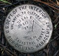
 view gallery view galleryW2.1 km | T13S R9E S8 9 16 17 COR - Jefferson County, OR in Public Land Survey Marks PLSS section corner remonumented by USDI-Bureau of Land Management, James E. Jelley in 1966; Land Corner Record T13S R9E J-09 posted by: Cooke17513 location: Oregon date approved: 03/09/2016 last visited: never |
 view gallery view gallerySE2.3 km | T13S R9E SECS 15 14 23 22 COR - Jefferson County, OR in Public Land Survey Marks PLSS section corner set by USDI-Bureau of Land Management in 1966 posted by: Cooke17513 location: Oregon date approved: 11/13/2011 last visited: never |
|