 view gallery view gallery W2.1 km W2.1 km
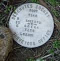
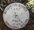
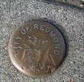
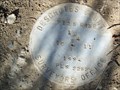
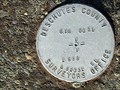
|   T14S R13E S32 33 T15S R13E S5 4 COR - Deschutes County, OR T14S R13E S32 33 T15S R13E S5 4 COR - Deschutes County, OR
in Public Land Survey Marks Central Oregon Grid mark designated 14133300; PLSS section corner set by Deschutes County Surveyors Office, Michael J. Berry in 2007 posted by:  Cooke17513 Cooke17513 location: Oregon date approved: 02/13/2014 last visited: never |
 view gallery view gallery SW2.4 km SW2.4 km
|  Geology of Dry Canyon Geology of Dry Canyon
in Oregon Historical Markers Sign about the geology of the Dry Canyon in Redmond, Oregon. posted by: Volcanoguy location: Oregon date approved: 03/02/2009 last visited: 10/19/2019 |
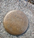
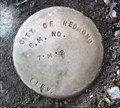
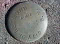
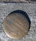
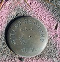
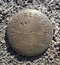 view gallery view gallerySW2.4 km |  5-K-1 CITY OF REDMOND BM 5-K-1 CITY OF REDMOND BM
in U.S. Benchmarks City of Redmond BM at the T-intersection of NW Canyon Rim Drive with NW 10th Street in Redmond, OR posted by: Cooke17513 location: Oregon date approved: 02/20/2014 last visited: never |
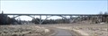 view gallery view gallerySW2.7 km |  Maple Avenue Bridge - Redmond, Oregon Maple Avenue Bridge - Redmond, Oregon
in Arch Bridges A triple-arch concrete arch bridge across Dry Canyon in Redmond, Oregon.
posted by: Volcanoguy location: Oregon date approved: 03/08/2009 last visited: 03/09/2009 |
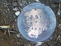
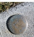 view gallery view gallerySW2.9 km | 6-L-2 CITY OF REDMOND BM in U.S. Benchmarks City of Redmond BM at the T-intersection of NW Larch Avenue with NW Canyon Drive in Redmond, OR posted by: Cooke17513 location: Oregon date approved: 02/21/2014 last visited: never |
 view gallery view galleryW2.9 km | T14S R13E S29 32 1/4 COR - Deschutes County, OR in Public Land Survey Marks PLSS quarter corner set by Deschutes County Surveyors Office, Cornelius H. Ketcham in 1987 posted by: Cooke17513 location: Oregon date approved: 02/14/2014 last visited: never |
 view gallery view gallery S3.1 km S3.1 km
| 7-L-1 CITY OF REDMOND BM in U.S. Benchmarks City of Redmond BM N of the intersection of NW Jackpine Avenue with NW 8th Street posted by: Cooke17513 location: Oregon date approved: 02/21/2014 last visited: never |
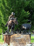 view gallery view galleryS3.2 km |  Western Swing in Redmond, OR Western Swing in Redmond, OR
in Equestrian Statues This statue greets drivers as they enter Redmond, Oregon. posted by: Queens Blessing location: Oregon date approved: 08/01/2009 last visited: 11/27/2020 |
 view gallery view galleryS3.2 km | 7-M-2 CITY OF REDMOND BM in U.S. Benchmarks City of Redmond BM at T-intersection of NE Hemlock Avenue and NW Canal Boulevard in Redmond, OR posted by: Cooke17513 location: Oregon date approved: 02/25/2014 last visited: never |
 view gallery view galleryS3.2 km | 7-L-3 CITY OF REDMOND BM in U.S. Benchmarks City of Redmond BM at the intersection of NW Ivy Avenue with NW 7th Street in Redmond, OR posted by: Cooke17513 location: Oregon date approved: 02/21/2014 last visited: never |
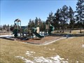 view gallery view gallerySW3.2 km |  West Canyon Rim Park - Redmond, Oregon West Canyon Rim Park - Redmond, Oregon
in Municipal Parks and Plazas A community park located on the west rim of Dry Canyon. posted by: Volcanoguy location: Oregon date approved: 03/02/2009 last visited: 03/02/2009 |
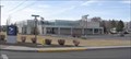 view gallery view galleryS3.4 km |  Redmond, OR, 97756 Redmond, OR, 97756
in U.S. Post Offices The Redmond, OR Post Office. posted by: Volcanoguy location: Oregon date approved: 03/06/2007 last visited: 11/27/2020 |
 view gallery view galleryS3.4 km | 8-M-2 CITY OF REDMOND BM in U.S. Benchmarks City of Redmond BM at the intersection of NW Greenwood Avenue and NW Canal Boulevard in Redmond, OR posted by: Cooke17513 location: Oregon date approved: 02/25/2014 last visited: never |
 view gallery view galleryS3.4 km | T15S R13E S10 11 1/4 COR -- Deschutes County, OR in Public Land Survey Marks PLSS quarter corner; Deschutes County Surveyors Office cap set by Kenneth L. Grantham in 1994 posted by: Cooke17513 location: Oregon date approved: 02/26/2012 last visited: never |
 view gallery view galleryS3.5 km | 8-M-1 CITY OF REDMOND BM in U.S. Benchmarks City of Redmond BM at the intersection of NW Fir Avenue and NE 5th Street in Redmond, OR posted by: Cooke17513 location: Oregon date approved: 02/25/2014 last visited: never |
 view gallery view galleryS3.5 km | 8-L-1 CITY OF REDMOND BM in U.S. Benchmarks City of Redmond BM at the intersection of NW Greenwood Avenue and NW 10th Street in Redmond, OR posted by: Cooke17513 location: Oregon date approved: 02/25/2014 last visited: never |
 view gallery view galleryW3.7 km | RED 13 (DEA) - Deschutes County, OR in U.S. Benchmarks Central Oregon Grid mark set by David Evans and Associates, Inc. in 1993 posted by: Cooke17513 location: Oregon date approved: 12/01/2011 last visited: never |
 view gallery view gallerySW3.7 km | T15S R13E NE 1/16 S8 COR -- Deschutes County, OR in Public Land Survey Marks PLSS sixteenth corner monumented by E.G. Mansfield posted by: Cooke17513 location: Oregon date approved: 08/21/2022 last visited: never |
 view gallery view gallery SE3.7 km SE3.7 km
| T15S R13E S2 1 12 11 COR -- Deschutes County, OR in Public Land Survey Marks PLSS section corner and Central Oregon Grid mark, designated 15130100; Deschutes County Surveyors Office cap set by W.C. Kauffman in 1994 posted by: Cooke17513 location: Oregon date approved: 02/26/2012 last visited: never |
 view gallery view galleryS3.7 km |  Headquarters Station (#401), Redmond, Oregon Headquarters Station (#401), Redmond, Oregon
in Firehouses Redmond’s Headquarters Station is located on Dogwood Ave. posted by: Volcanoguy location: Oregon date approved: 02/10/2006 last visited: never |
 view gallery view galleryS4.2 km | T15S R13E S10 11 14 15 COR -- Deschutes County, OR in Public Land Survey Marks PLSS section corner and Central Oregon Grid mark, designated 15131100; Deschutes County Surveyors Office cap set by W.C. Kauffman in November 1994 posted by: Cooke17513 location: Oregon date approved: 02/18/2012 last visited: never |
 view gallery view gallery N4.2 km N4.2 km
|  Robert Dale Maxwell Jr.-Terrebonne, OR Robert Dale Maxwell Jr.-Terrebonne, OR
in Medal Of Honor Resting Places World War II Medal of Honor Recipient for action near Besancon, France on September 7, 1944. He is buried in Terrebonne Pioneer Cemetery, Terrebonne, OR in Block 1, Lot 85E. posted by:  Don.Morfe Don.Morfe location: Oregon date approved: 10/28/2019 last visited: never |
 view gallery view gallerySW4.2 km | T15S R13E S8 C 1/4 COR -- Deschutes County, OR in Public Land Survey Marks PLSS center quarter corner set by E. Mansfield, PLS 0010 in 1978 posted by: Cooke17513 location: Oregon date approved: 05/13/2014 last visited: never |
 view gallery view gallerySE4.2 km | T15S R13E S11 12 1/4 COR -- Deschutes County, OR in Public Land Survey Marks PLSS quarter corner; GLO cap set by Norman D. Price in 1949 posted by: Cooke17513 location: Oregon date approved: 02/26/2012 last visited: never |
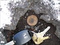
 view gallery view galleryN4.3 km | GIS 021 - Deschutes County, OR in U.S. Benchmarks Central Oregon Grid mark set by Deschutes County Surveyors Office in 1988 posted by: Cooke17513 location: Oregon date approved: 12/02/2011 last visited: never |
|