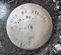
 view gallery view gallery W0.6 km W0.6 km
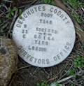
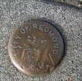
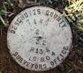
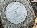
|   T14S R13E S32 33 T15S R13E S5 4 COR - Deschutes County, OR T14S R13E S32 33 T15S R13E S5 4 COR - Deschutes County, OR
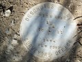
in Public Land Survey Marks Central Oregon Grid mark designated 14133300; PLSS section corner set by Deschutes County Surveyors Office, Michael J. Berry in 2007 posted by:  Cooke17513 Cooke17513 location: Oregon date approved: 02/13/2014 last visited: never |
 view gallery view galleryW0.8 km |  Geology of Dry Canyon Geology of Dry Canyon
in Oregon Historical Markers Sign about the geology of the Dry Canyon in Redmond, Oregon. posted by: Volcanoguy location: Oregon date approved: 03/02/2009 last visited: 10/19/2019 |
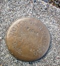
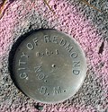
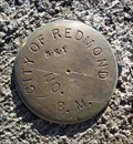 view gallery view gallery S1.1 km S1.1 km
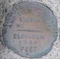
|  5-K-1 CITY OF REDMOND BM 5-K-1 CITY OF REDMOND BM
in U.S. Benchmarks City of Redmond BM at the T-intersection of NW Canyon Rim Drive with NW 10th Street in Redmond, OR posted by: Cooke17513 location: Oregon date approved: 02/20/2014 last visited: never |
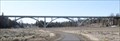 view gallery view galleryS1.4 km |  Maple Avenue Bridge - Redmond, Oregon Maple Avenue Bridge - Redmond, Oregon
in Arch Bridges A triple-arch concrete arch bridge across Dry Canyon in Redmond, Oregon.
posted by: Volcanoguy location: Oregon date approved: 03/08/2009 last visited: 03/09/2009 |
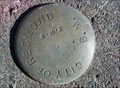
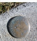 view gallery view galleryS1.8 km | 6-L-2 CITY OF REDMOND BM in U.S. Benchmarks City of Redmond BM at the T-intersection of NW Larch Avenue with NW Canyon Drive in Redmond, OR posted by: Cooke17513 location: Oregon date approved: 02/21/2014 last visited: never |
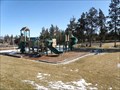 view gallery view galleryS2.1 km |  West Canyon Rim Park - Redmond, Oregon West Canyon Rim Park - Redmond, Oregon
in Municipal Parks and Plazas A community park located on the west rim of Dry Canyon. posted by: Volcanoguy location: Oregon date approved: 03/02/2009 last visited: 03/02/2009 |
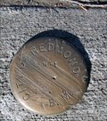
 view gallery view galleryS2.1 km | 7-L-1 CITY OF REDMOND BM in U.S. Benchmarks City of Redmond BM N of the intersection of NW Jackpine Avenue with NW 8th Street posted by: Cooke17513 location: Oregon date approved: 02/21/2014 last visited: never |
 view gallery view gallery SW2.3 km SW2.3 km
| T15S R13E NE 1/16 S8 COR -- Deschutes County, OR in Public Land Survey Marks PLSS sixteenth corner monumented by E.G. Mansfield posted by: Cooke17513 location: Oregon date approved: 08/21/2022 last visited: never |
 view gallery view galleryS2.3 km | 7-L-3 CITY OF REDMOND BM in U.S. Benchmarks City of Redmond BM at the intersection of NW Ivy Avenue with NW 7th Street in Redmond, OR posted by: Cooke17513 location: Oregon date approved: 02/21/2014 last visited: never |
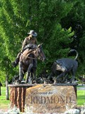 view gallery view galleryS2.3 km |  Western Swing in Redmond, OR Western Swing in Redmond, OR
in Equestrian Statues This statue greets drivers as they enter Redmond, Oregon. posted by: Queens Blessing location: Oregon date approved: 08/01/2009 last visited: 11/27/2020 |
 view gallery view gallery NW2.3 km NW2.3 km
| T14S R13E S29 32 1/4 COR - Deschutes County, OR in Public Land Survey Marks PLSS quarter corner set by Deschutes County Surveyors Office, Cornelius H. Ketcham in 1987 posted by: Cooke17513 location: Oregon date approved: 02/14/2014 last visited: never |
 view gallery view galleryW2.3 km | RED 13 (DEA) - Deschutes County, OR in U.S. Benchmarks Central Oregon Grid mark set by David Evans and Associates, Inc. in 1993 posted by: Cooke17513 location: Oregon date approved: 12/01/2011 last visited: never |
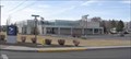 view gallery view galleryS2.4 km |  Redmond, OR, 97756 Redmond, OR, 97756
in U.S. Post Offices The Redmond, OR Post Office. posted by: Volcanoguy location: Oregon date approved: 03/06/2007 last visited: 11/27/2020 |
 view gallery view galleryS2.4 km | 7-M-2 CITY OF REDMOND BM in U.S. Benchmarks City of Redmond BM at T-intersection of NE Hemlock Avenue and NW Canal Boulevard in Redmond, OR posted by: Cooke17513 location: Oregon date approved: 02/25/2014 last visited: never |
 view gallery view galleryS2.6 km | 8-L-1 CITY OF REDMOND BM in U.S. Benchmarks City of Redmond BM at the intersection of NW Greenwood Avenue and NW 10th Street in Redmond, OR posted by: Cooke17513 location: Oregon date approved: 02/25/2014 last visited: never |
 view gallery view galleryS2.6 km | 8-M-2 CITY OF REDMOND BM in U.S. Benchmarks City of Redmond BM at the intersection of NW Greenwood Avenue and NW Canal Boulevard in Redmond, OR posted by: Cooke17513 location: Oregon date approved: 02/25/2014 last visited: never |
 view gallery view galleryS2.7 km | 8-M-1 CITY OF REDMOND BM in U.S. Benchmarks City of Redmond BM at the intersection of NW Fir Avenue and NE 5th Street in Redmond, OR posted by: Cooke17513 location: Oregon date approved: 02/25/2014 last visited: never |
 view gallery view gallerySW2.7 km | GIS 022 - Deschutes County, OR in U.S. Benchmarks Central Oregon Grid mark set by Deschutes County Surveyors Office in 1988 posted by: Cooke17513 location: Oregon date approved: 11/30/2011 last visited: never |
 view gallery view gallerySW2.7 km | T15S R13E S8 C 1/4 COR -- Deschutes County, OR in Public Land Survey Marks PLSS center quarter corner set by E. Mansfield, PLS 0010 in 1978 posted by: Cooke17513 location: Oregon date approved: 05/13/2014 last visited: never |
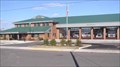 view gallery view galleryS2.9 km |  Headquarters Station (#401), Redmond, Oregon Headquarters Station (#401), Redmond, Oregon
in Firehouses Redmond’s Headquarters Station is located on Dogwood Ave. posted by: Volcanoguy location: Oregon date approved: 02/10/2006 last visited: never |
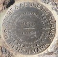 view gallery view galleryW3.1 km | QD0760 - USCGS Q419, Oregon in U.S. Benchmarks U.S. Coast & Geodetic Survey benchmark Q419. posted by: Volcanoguy location: Oregon date approved: 03/04/2009 last visited: 03/04/2009 |
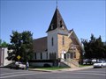 view gallery view galleryS3.4 km |  First Presbyterian Church of Redmond - Redmond, OR First Presbyterian Church of Redmond - Redmond, OR
in U.S. National Register of Historic Places The First Presbyterian Church is the oldest standing church structure in Redmond. posted by: Volcanoguy location: Oregon date approved: 06/18/2006 last visited: 06/18/2006 |
 view gallery view galleryS3.4 km | Ehret Brothers Store - Redmond, OR in Oregon Historical Markers The Ehret Brothers Store is located at 251 SW 6th St.
posted by: Volcanoguy location: Oregon date approved: 06/28/2006 last visited: 06/28/2006 |
 view gallery view galleryS3.4 km | QD0853 - USCGS C 105, Oregon in U.S. Benchmarks NGS PID QD0853 - USCGS C 105 posted by: Volcanoguy location: Oregon date approved: 02/26/2007 last visited: 02/27/2007 |
 view gallery view gallery SE3.4 km SE3.4 km
| T15S R13E S10 11 1/4 COR -- Deschutes County, OR in Public Land Survey Marks PLSS quarter corner; Deschutes County Surveyors Office cap set by Kenneth L. Grantham in 1994 posted by: Cooke17513 location: Oregon date approved: 02/26/2012 last visited: never |
|