 view gallery view gallery S16.6 km S16.6 km
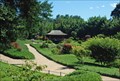
|   Le Vallon du Dragon à La Bambouseraie - Générargues Anduze, France Le Vallon du Dragon à La Bambouseraie - Générargues Anduze, France
in Japanese Gardens [FR] Un splendide jardin japonais aménagé dans le parc de la Bambouseraie, à Générargues Anduze
[ENG] A beautiful Japanese garden built in the park of the Bambouseraie, Générargues Anduze posted by:  Chris777 Chris777 location: France date approved: 08/18/2008 last visited: 07/23/2013 |
 view gallery view gallery NE17.1 km NE17.1 km
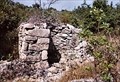
|  Dolmen des Pins de l'Ismael Dolmen des Pins de l'Ismael
in Megalithic Monuments Dolmen des Pins de l'Ismael 17 is a burial chamber in the community of Courry, Departement of Gard, Region of Languedoc - Rousillon posted by: Axel-F location: Occitanie, France date approved: 07/28/2011 last visited: 07/28/2011 |
 view gallery view gallery SE17.2 km SE17.2 km
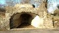
|  Four à Chaux, Saint-Hilaire-De-Brethmas, Gard, France Four à Chaux, Saint-Hilaire-De-Brethmas, Gard, France
in Ovens and Kilns [FR] Ancien Four à chaux du XIXe siècle sur la commune de Saint Hilaire de Brethmas. [EN] Former Lime kiln of the 19th century in the commune of Saint Hilaire de Brethmas. posted by: barbudu30 location: Occitanie, France date approved: 01/31/2017 last visited: never |
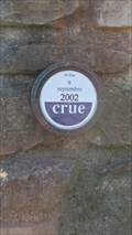 view gallery view gallerySE17.2 km |  Repères de Crue - Pont Noyé Quartier Tribies - Saint Hilaire de Brethmas Repères de Crue - Pont Noyé Quartier Tribies - Saint Hilaire de Brethmas
in French Benchmarks Repères de crue - Avène 2002 posted by: barbudu30 location: Occitanie, France date approved: 01/29/2017 last visited: never |
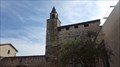
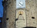 view gallery view galleryS18.3 km |  Anduze, Gard, Southern France Anduze, Gard, Southern France
in Sundials A fine example of a vertical sundial on a circular tower. posted by: GeoRams location: France date approved: 03/09/2008 last visited: 12/27/2016 |
 view gallery view gallery E20 km E20 km
|  Dead Vehicle at the edge of Valat de Séguissous, Gard Dead Vehicle at the edge of Valat de Séguissous, Gard
in Abandoned Dead Vehicles [EN] A carcass found during a hike. [FR] Une carcasse de voiture trouvée lors d'une randonnée. posted by: Itamae location: Occitanie, France date approved: 06/22/2017 last visited: 10/11/2017 |
 view gallery view gallery N20.4 km N20.4 km
|  546m- Ponteils- Ponteils et Brésis- Gard- languedoc-Roussillon- France 546m- Ponteils- Ponteils et Brésis- Gard- languedoc-Roussillon- France
in Elevation Signs Panneau indicateur pour les randonneurs. posted by: SISABIEL location: Occitanie, France date approved: 11/22/2017 last visited: never |
 view gallery view galleryN20.6 km |  L'Eglise Notre Dame- Ponteils et Brésis- Gard- Languedoc-Roussillon- France L'Eglise Notre Dame- Ponteils et Brésis- Gard- Languedoc-Roussillon- France
in This Old Church Eglise de Notre Dame à Ponteils et Brésis. posted by: SISABIEL location: Occitanie, France date approved: 11/23/2017 last visited: never |
 view gallery view galleryN20.6 km |  Le clocher de l'Eglise Notre Dame- Ponteils et Brésis- Gard- Languedoc-Roussillon- France Le clocher de l'Eglise Notre Dame- Ponteils et Brésis- Gard- Languedoc-Roussillon- France
in Bell Towers Le clocher de l'Eglise Notre Dame. posted by: SISABIEL location: Occitanie, France date approved: 11/22/2017 last visited: never |
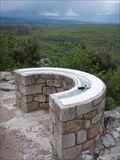 view gallery view galleryNE20.9 km |  Table du fort de Banne (07) Table du fort de Banne (07)
in Orientation Tables Table située à une extrémité du château. Elle offre un magnifique panorama. posted by: Pat5488 location: France date approved: 04/19/2009 last visited: never |
 view gallery view galleryN25.3 km |  Le pont Saint Jean- Villefort- Lozère- Languedoc-Roussillon- France Le pont Saint Jean- Villefort- Lozère- Languedoc-Roussillon- France
in Monuments Historiques Français Le pont romain de Villefort posted by: SISABIEL location: Occitanie, France date approved: 11/22/2017 last visited: never |
 view gallery view galleryN25.3 km |  Le pont Saint Jean- Villefort- Lozère- Languedoc-Roussillon- France Le pont Saint Jean- Villefort- Lozère- Languedoc-Roussillon- France
in Arch Bridges le pont romain posted by: SISABIEL location: Occitanie, France date approved: 11/22/2017 last visited: never |
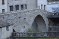 view gallery view galleryN25.3 km |  Le pont Saint Jean- Villefort- Lozère- Languedoc-Roussillon- France Le pont Saint Jean- Villefort- Lozère- Languedoc-Roussillon- France
in Stone Bridges Le pont romain Saint Jean à Villefort. posted by: SISABIEL location: Occitanie, France date approved: 12/11/2017 last visited: never |
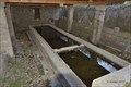 view gallery view galleryN25.3 km | ") Le lavoir- Villefort- Lozère- Languedoc-Roussillon- France Le lavoir- Villefort- Lozère- Languedoc-Roussillon- France
in Lavoir (wash houses) Le lavoir de Villefort posted by: SISABIEL location: Occitanie, France date approved: 11/22/2017 last visited: never |
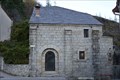 view gallery view galleryN25.3 km | La chapelle saint Jean- Villefort- Lozère- Languedoc-Roussillon- France in Roman Catholic Churches La chapelle Saint Jean. posted by: SISABIEL location: Occitanie, France date approved: 11/22/2017 last visited: never |
 view gallery view galleryN25.3 km | La chapelle saint Jean- Villefort- Lozère- Languedoc-Roussillon- France in Monuments Historiques Français La chapelle st Jean posted by: SISABIEL location: Occitanie, France date approved: 11/23/2017 last visited: never |
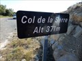 view gallery view galleryNE27.2 km | 371 m -col de la Serrre - Beaulieu,France in Elevation Signs It allows to connect the towns of Beaulieu and Bessas
il permet de relié les villes de Beaulieu et de Bessas posted by: sara et gege location: Auvergne-Rhône-Alpes, France date approved: 08/09/2017 last visited: 08/10/2017 |
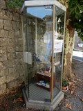 view gallery view galleryNE28.8 km |  cabine a livre - Chandolas - France cabine a livre - Chandolas - France
in Free Community Book Exchanges une ancienne cabine telephonique posted by: sara et gege location: Auvergne-Rhône-Alpes, France date approved: 07/24/2017 last visited: 07/24/2017 |
 view gallery view galleryNE29 km | repere geodesique CHANDOLAS III in French Benchmarks le clocher de l eglise posted by: sara et gege location: Auvergne-Rhône-Alpes, France date approved: 07/25/2017 last visited: 07/25/2017 |
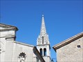
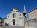 view gallery view galleryNE29 km | Eglise St Martin - Chandolas, France in This Old Church A good size church in this small village.
Une église de belle taille dans ce petit village. posted by: sara et gege location: Auvergne-Rhône-Alpes, France date approved: 12/12/2020 last visited: 07/13/2021 |
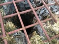 view gallery view galleryE29.6 km |  Aven du lac de Trepadone - Méjannes le Clap - France Aven du lac de Trepadone - Méjannes le Clap - France
in Natural Sinkholes A proximité du lac de Trépadone, en bordure de la route menant à
Méjannes, s'ouvre un aven qui a tout naturellement le nom du point d'eau.
Close to Lake Trepadone, on the road to Méjannes, opens an aven which naturally has the name of the water point posted by: Alfouine location: Occitanie, France date approved: 09/22/2017 last visited: never |
 view gallery view galleryE29.6 km | ") Aven du lac de Trepadone - Méjannes le Clap - France Aven du lac de Trepadone - Méjannes le Clap - France
in Cave Entrances (Natural) A proximité du lac de Trépadone, en bordure de la route menant à
Méjannes, s'ouvre un aven qui a tout naturellement le nom du point d'eau.
Close to Lake Trepadone, on the road to Méjannes, opens an aven which naturally has the name of the water point posted by: Alfouine location: Occitanie, France date approved: 09/19/2017 last visited: never |
 view gallery view galleryE29.6 km | Château de Barjac, Ardèche, France in Monuments Historiques Français [FR] Le château de Barjac, aussi appelé château des Comtes du Roure [EN] The castle of Barjac, also called castle of the Counts of Roure posted by: Blanko36 location: Auvergne-Rhône-Alpes, France date approved: 10/10/2022 last visited: 10/10/2022 |
 view gallery view galleryE29.6 km |  Château de Barjac, Ardèche, France Château de Barjac, Ardèche, France
in Wikipedia Entries [FR] Le château de Barjac, aussi appelé château des Comtes du Roure [EN] The castle of Barjac, also called castle of the Counts of Roure posted by: Blanko36 location: Auvergne-Rhône-Alpes, France date approved: 10/10/2022 last visited: 10/10/2022 |
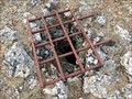 view gallery view galleryE29.6 km | L'aven de la chèvre d'André - Méjannes le Clap - France in Natural Sinkholes Une magnifique doline protégée par une grille et dont l'effondrement à créé un aven caractéristique de cette région.
A magnificent sinkhole protected by a gate and whose collapse created an aven characteristic of this region. posted by: Alfouine location: Occitanie, France date approved: 09/22/2017 last visited: never |
|