 view gallery view gallery N0.2 km N0.2 km
|   Only Town With a Real Redstone Missile - Warren NH Only Town With a Real Redstone Missile - Warren NH
in Roadside Attractions Installed in 1971, the empty missile was donated to the town after the line as a whole had been discontinued in favor or newer technology. posted by:  nomadwillie nomadwillie location: New Hampshire date approved: 02/23/2023 last visited: never |
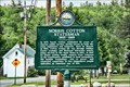 view gallery view galleryN0.2 km |  Norris Cotton Statesman - Warren, NH Norris Cotton Statesman - Warren, NH
in New Hampshire Historical Markers Marker is near the intersection of Water Street/School St and Mount Moosilauke Highway (New Hampshire Route 25/118), just passed the Warren Volunteer Fire Department. posted by: nomadwillie location: New Hampshire date approved: 02/22/2023 last visited: never |
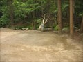
 view gallery view gallery S5 km S5 km
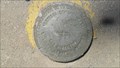
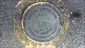
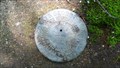
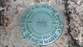
|  X 34 RESET 1985 (NGS, Wentworth, NH) X 34 RESET 1985 (NGS, Wentworth, NH)
in U.S. Benchmarks A NGS vertical control mark, located in Wentworth, NH.
The NHDOT ID# is 475-0050. posted by:  NH2beers NH2beers location: New Hampshire date approved: 05/31/2012 last visited: never |
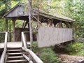
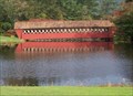
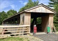 view gallery view galleryS6.3 km |  Friendship Bridge - Wentworth, NH Friendship Bridge - Wentworth, NH
in Covered Bridges A pedestrian covered bridge located in the center of Wentworth Village, New Hampshire. posted by: MonkeyAndTheEngineer location: New Hampshire date approved: 08/24/2019 last visited: 07/10/2022 |
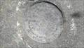
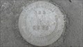
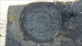 view gallery view galleryS6.3 km | OC0943: W 34 1955 (USC&GS/NGS, Wentworth, NH) in U.S. Benchmarks A USC&GS standard bench mark disk, located in Wentworth, NH.
The NGS PID# is OC0943.
The NHDOT ID# is 475-0020. posted by: NH2beers location: New Hampshire date approved: 05/31/2012 last visited: never |
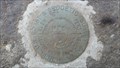
 view gallery view galleryS8.7 km | V 34 RESET 1973 (NGS, Wentworth, NH) in U.S. Benchmarks A NGS vertical control mark, located in Wentworth, NH.
The NHDOT ID# is 475-0040. posted by: NH2beers location: New Hampshire date approved: 05/31/2012 last visited: never |
 view gallery view gallery NE12.1 km NE12.1 km
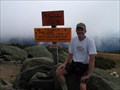
|  Mt Moosilauke Mt Moosilauke
in Mountain Summits A gentle 4,000 foot mountain on the western edge of New Hampshire's White Mountains, offering pleasant trails and spectacular views. posted by: cache_test_dummies location: New Hampshire date approved: 09/16/2005 last visited: 08/25/2008 |
 view gallery view gallery NW12.2 km NW12.2 km
|  N 44 00.000 W 72 00.000- Piermont, NH N 44 00.000 W 72 00.000- Piermont, NH
in Confluence Spots One of 4 confluences in NH posted by: Mountain_Wanderer location: New Hampshire date approved: 08/10/2006 last visited: 04/27/2015 |
 view gallery view galleryS14.8 km | 527 RESET 1963 (USDI, Rumney, NH) in U.S. Benchmarks A USDI standard disk, located in Rumney, NH.
The NHDOT ID# is 395-0120. posted by: NH2beers location: New Hampshire date approved: 05/31/2012 last visited: never |
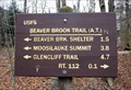 view gallery view galleryNE15.3 km |  Beaver Brook Trail to Cascades, west of Lincoln, NH Beaver Brook Trail to Cascades, west of Lincoln, NH
in Appalachian Trail The trail is steep and dangerous at this point, off of NH Route 112. posted by: ronjean location: New Hampshire date approved: 12/10/2017 last visited: never |
 view gallery view galleryNE15.3 km | Allen Hollis Bridge in Covered Bridges Allen Hollis Footbridge is within the Lost River Gorge in northern New Hampshire. Only accessible by going into the gorge, but if you ask at the gate. They will instruct you. Open only May to October. posted by: CoveredBridgeGuy location: New Hampshire date approved: 11/15/2008 last visited: 05/11/2019 |
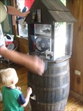 view gallery view galleryNE15.4 km |  Lost River Gorge and Boulder Caves Lost River Gorge and Boulder Caves
in Penny Smashers This penny smashers is located inside of the gift shop area. You can access the smasher without having to pay an entrance fee. posted by: Team Jackal location: New Hampshire date approved: 07/16/2007 last visited: 05/11/2019 |
 view gallery view gallery SE15.4 km SE15.4 km
| OC0926: H 25 RESET 1963 (USC&GS/NGS, Rumney, NH) in U.S. Benchmarks A USC&GS standard bench mark disk, located in Rumney, NH.
The NGS PID# is OC0926.
The NHDOT ID# is 395-0070. posted by: NH2beers location: New Hampshire date approved: 05/31/2012 last visited: never |
 view gallery view galleryNE16.1 km |  Lost River Valley Campgrounds Lost River Valley Campgrounds
in Campgrounds A peaceful family campground in North Woodstock, NH posted by: Team Jackal location: New Hampshire date approved: 07/10/2007 last visited: 06/23/2007 |
 view gallery view gallerySE16.7 km | 395 0220 (NHDOT, Rumney, NH) in U.S. Benchmarks A NHDOT standard disk, located in Rumney, NH.
The NHDOT ID# is 395-0220. posted by: NH2beers location: New Hampshire date approved: 05/31/2012 last visited: never |
 view gallery view gallerySE16.7 km | OC0923: M 35 1955 (USC&GS/NGS, Rumney, NH) in U.S. Benchmarks A USC&GS standard bench mark disk, located in Rumney, NH.
The NGS PID# is OC0923.
The NHDOT ID# is 395-0060. posted by: NH2beers location: New Hampshire date approved: 05/31/2012 last visited: never |
 view gallery view gallery E17.2 km E17.2 km
| Jack-O-Lantern Bridge in Covered Bridges This is an exact 50% reduction of a Woodstock bridge which was burned down in 1971. It is on the Jack O'Lantern Resort Golf Course in Woodstock, NH posted by: CoveredBridgeGuy location: New Hampshire date approved: 12/21/2008 last visited: 07/14/2018 |
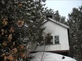
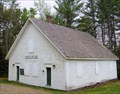 view gallery view galleryE17.9 km |  Thornton, NH Thornton, NH
in City and Town Halls Town Hall, Thornton, NH posted by: silverquill location: New Hampshire date approved: 05/21/2006 last visited: 04/25/2009 |
 view gallery view galleryE18.2 km | OC1009: P 5 (USC&GS/NGS, Thornton, NH) in U.S. Benchmarks A USC&GS standard bench mark disk, located in Thornton, NH.
The NGS PID# is OC1009.
The NHDOT ID# is 449-0070. posted by: NH2beers location: New Hampshire date approved: 05/17/2011 last visited: never |
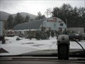 view gallery view gallerySE19.2 km |  The Quonset Hut The Quonset Hut
in Quonset Huts Located on Rt 25 in Rumney, NH posted by: Mountain_Wanderer location: New Hampshire date approved: 01/24/2006 last visited: 04/14/2009 |
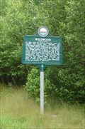 view gallery view galleryN19.5 km | Wildwood in New Hampshire Historical Markers Intersection of Tunnel Brook Road and Rte 112,in the vicinity of the old one room school, mills, stone gate and stone fireplace posted by: nomadwillie location: New Hampshire date approved: 03/28/2011 last visited: 06/27/2010 |
 view gallery view galleryNE19.6 km |  Rock of Ages Chapel Rock of Ages Chapel
in Waychapels On Rt 3 in Woodstock, New Hampshire posted by: Mountain_Wanderer location: New Hampshire date approved: 01/25/2006 last visited: 04/04/2009 |
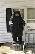 view gallery view galleryNE19.8 km |  Carved Bear - North Woodstock, New Hampshire Carved Bear - North Woodstock, New Hampshire
in Bear Statues Carved bear at the entrance of town hall in Woodstock, NH. posted by: MonkeyAndTheEngineer location: New Hampshire date approved: 05/19/2019 last visited: never |
 view gallery view gallery W20 km W20 km
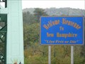
|  NH/VT on Hwy 25A NH/VT on Hwy 25A
in Border Crossings A quiet border crossing on Hwy 25A (Bridge St) between New Hampshire and Vermont. posted by: PeterNoG location: New Hampshire date approved: 12/12/2010 last visited: 10/03/2009 |
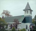 view gallery view galleryNE20 km |  Pemigewasset River Antiques/Freewill Baptist Church - North Woodstock, NH Pemigewasset River Antiques/Freewill Baptist Church - North Woodstock, NH
in This Old Church The Freewill Baptist Church building, in North Woodstock, New Hampshire, was built in 1826, but is now home to Pemigewasset River Antiques. The propietors love to talk history and visitors to browse the displays and antiques for sale. posted by: silverquill location: New Hampshire date approved: 01/01/2008 last visited: 10/06/2022 |
|